Cresson, Kansas
| Cresson, Kansas | |
|---|---|
| Coordinates: 39°16′40″N 99°35′07″W / 39.27778°N 99.58528°WCoordinates: 39°16′40″N 99°35′07″W / 39.27778°N 99.58528°W | |
| Country | United States |
| State | Kansas |
| County | Rooks |
| Elevation | 2,234 ft (681 m) |
| Time zone | UTC-6 (Central (CST)) |
| • Summer (DST) | UTC-5 (CDT) |
| GNIS feature ID | 482530[1] |


Cresson was a small settlement in Northampton Township, Rooks County, Kansas, United States.
History
Cresson, Kansas (named for Cresson, PA) was granted a post office in 1879.[2] In 1887, rumors circulated that Union Pacific Railroad would lay track 1-1/2 miles to the south of Cresson. Many citizens and businesses abandoned Cresson to form the community of New Cresson along the expected railroad route. In 1888, Union Pacific established the railroad near the original location of Cresson, then created Palco as a depot. Nothing is left of Cresson or New Cresson.[3]
References
- ↑ "US Board on Geographic Names". United States Geological Survey. 1984-07-01. Retrieved 2017-12-23.
- ↑ "Kansas Post Offices, 1828-1961". Kansas Historical Society. Retrieved 2017-12-23.
- ↑ Palco Kansas Centennial September 1988, 1988, p.19.
Municipalities and communities of Rooks County, Kansas, United States | ||
|---|---|---|
| Cities | 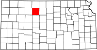 | |
| Unincorporated community | ||
| Ghost towns | ||
| Townships | ||
This article is issued from
Wikipedia.
The text is licensed under Creative Commons - Attribution - Sharealike.
Additional terms may apply for the media files.