Sugarloaf, Kansas
| Sugarloaf, Kansas | |
|---|---|
| Coordinates: 39°32′10″N 99°23′47″W / 39.53611°N 99.39639°WCoordinates: 39°32′10″N 99°23′47″W / 39.53611°N 99.39639°W | |
| Country | United States |
| State | Kansas |
| County | Rooks |
| Elevation | 2,077 ft (633 m) |
| Time zone | UTC-6 (Central (CST)) |
| • Summer (DST) | UTC-5 (CDT) |
| GNIS feature ID | 482523[1] |


Sugarloaf was a small settlement in Sugar Loaf Township, Rooks County, Kansas, United States.
History
Sugar Loaf (aka Sugarloaf) was issued a post office in 1878. The post office was renamed Sugarloaf in 1895. The Sugarloaf post office was discontinued in 1904.[2] The population in 1910 was 15.[3]
References
- ↑ "US Board on Geographic Names". United States Geological Survey. 1984-07-01. Retrieved 2017-12-30.
- ↑ "Kansas Post Offices, 1828-1961". Kansas Historical Society. Retrieved 2017-12-30.
- ↑ Blackmar, Frank Wilson (1912). Kansas: A Cyclopedia of State History, Volume 2, Chicago: Standard Publishing Company, p. 785
Municipalities and communities of Rooks County, Kansas, United States | ||
|---|---|---|
| Cities | 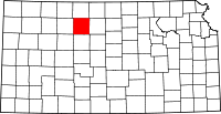 | |
| Unincorporated community | ||
| Ghost towns | ||
| Townships | ||
This article is issued from
Wikipedia.
The text is licensed under Creative Commons - Attribution - Sharealike.
Additional terms may apply for the media files.