Wingo, Kentucky
| Wingo, Kentucky | |
|---|---|
| City | |
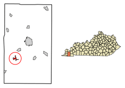 Location of Wingo in Graves County, Kentucky. | |
| Coordinates: 36°38′41″N 88°44′11″W / 36.64472°N 88.73639°WCoordinates: 36°38′41″N 88°44′11″W / 36.64472°N 88.73639°W | |
| Country | United States |
| State | Kentucky |
| County | Graves |
| Area | |
| • Total | 0.98 sq mi (2.54 km2) |
| • Land | 0.98 sq mi (2.53 km2) |
| • Water | 0.008 sq mi (0.02 km2) |
| Elevation | 502 ft (153 m) |
| Population (2010) | |
| • Total | 632 |
| • Estimate (2016)[1] | 636 |
| • Density | 648/sq mi (250.2/km2) |
| Time zone | UTC-6 (Central (CST)) |
| • Summer (DST) | UTC-5 (CDT) |
| ZIP code | 42088 |
| Area code(s) | 270 & 364 |
| FIPS code | 21-83856 |
| GNIS feature ID | 0506944 |
Wingo is a home rule-class city in Graves County, Kentucky, United States. The population was 632 at the 2010 census.[2]
Geography
Wingo is located 10 miles (16 km) southwest of Mayfield, the county seat, and 13 miles (21 km) northeast of Fulton, at 36°38′41″N 88°44′11″W / 36.64472°N 88.73639°W (36.644711, -88.736509).[3] U.S. Route 45 passes through the center of town connecting the two larger cities. The Purchase Parkway runs just west of Wingo, with access from Exit 14.
According to the United States Census Bureau, Wingo has a total area of 0.97 square miles (2.5 km2), of which 0.01 square miles (0.02 km2), or 0.70%, is water.[2]
Demographics
| Historical population | |||
|---|---|---|---|
| Census | Pop. | %± | |
| 1880 | 212 | — | |
| 1890 | 451 | 112.7% | |
| 1900 | 418 | −7.3% | |
| 1910 | 404 | −3.3% | |
| 1920 | 419 | 3.7% | |
| 1930 | 479 | 14.3% | |
| 1940 | 475 | −0.8% | |
| 1950 | 451 | −5.1% | |
| 1960 | 340 | −24.6% | |
| 1970 | 593 | 74.4% | |
| 1980 | 606 | 2.2% | |
| 1990 | 568 | −6.3% | |
| 2000 | 581 | 2.3% | |
| 2010 | 632 | 8.8% | |
| Est. 2016 | 636 | [1] | 0.6% |
| U.S. Decennial Census[4] | |||
As of the census[5] of 2000, there were 581 people, 246 households, and 177 families residing in the city. The population density was 640.3 people per square mile (246.5/km²). There were 281 housing units at an average density of 309.7 per square mile (119.2/km²). The racial makeup of the city was 96.21% White, 2.93% African American, 0.34% Native American, 0.17% from other races, and 0.34% from two or more races. Hispanic or Latino of any race were 1.20% of the population.
There were 246 households out of which 32.1% had children under the age of 18 living with them, 51.2% were married couples living together, 15.9% had a female householder with no husband present, and 28.0% were non-families. 25.2% of all households were made up of individuals and 15.0% had someone living alone who was 65 years of age or older. The average household size was 2.36 and the average family size was 2.71.
In the city, the population was spread out with 26.7% under the age of 18, 6.5% from 18 to 24, 25.1% from 25 to 44, 24.6% from 45 to 64, and 17.0% who were 65 years of age or older. The median age was 39 years. For every 100 females, there were 82.7 males. For every 100 females age 18 and over, there were 82.1 male.
The median income for a household in the city was $28,083, and the median income for a family was $30,500. Males had a median income of $30,000 versus $19,375 for females. The per capita income for the city was $17,526. About 17.7% of families and 17.0% of the population were below the poverty line, including 18.0% of those under age 18 and 13.0% of those age 65 or over.
References
- 1 2 "Population and Housing Unit Estimates". Retrieved June 9, 2017.
- 1 2 "Geographic Identifiers: 2010 Demographic Profile Data (G001): Wingo city, Kentucky". American Factfinder. U.S. Census Bureau. Retrieved December 12, 2016.
- ↑ "US Gazetteer files: 2010, 2000, and 1990". United States Census Bureau. 2011-02-12. Retrieved 2011-04-23.
- ↑ "Census of Population and Housing". Census.gov. Retrieved June 4, 2015.
- ↑ "American FactFinder". United States Census Bureau. Retrieved 2008-01-31.
Municipalities and communities of Graves County, Kentucky, United States | ||
|---|---|---|
| Cities | 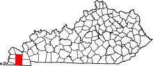 | |
| CDPs | ||
| Unincorporated communities | ||
| Footnotes | ‡This populated place also has portions in an adjacent county or counties | |