Wiay, Uist
| Gaelic name | Bhuia/Fuidheigh |
|---|---|
| Location | |
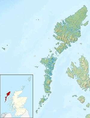 Wiay Wiay shown within the Outer Hebrides | |
| OS grid reference | NF873459 |
| Coordinates | 57°24′04″N 7°12′11″W / 57.401°N 7.203°W |
| Physical geography | |
| Island group | Outer Hebrides |
| Area | 375 ha (927 acres) |
| Area rank | 78= [1] |
| Highest elevation | Beinn a' Tuath 102 m (335 ft) |
| Administration | |
| Sovereign state | United Kingdom |
| Country | Scotland |
| Council area | Na h-Eileanan Siar |
| Demographics | |
| Population | 0[2] |
| References | [3][4][5] |
Wiay (Scottish Gaelic: Bhuia or Fuidheigh) is an uninhabited island in the Outer Hebrides.
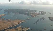
It lies south-east of Benbecula and measures approximately 375 ha (927 acres). The island is very flat with fertile ground and sandy beaches to the west whilst the east is predominately peat moorland with a rocky coastline incorporating many small islands and inlets. The highest point on the island is Beinn a’ Tuath which rises to 335 ft. On the west side of the island are the ruins of an old cottage overlooking Bagh na Murla. The Eileanan Chearabhaigh lie to the north beyond Loch a' Laip.
In the 18th century Bonnie Prince Charlie is said to have hidden in a cave on the island after the Battle of Culloden.[6] The cave, known as Prince Charlie's Rest, is found to the east of the island at the foot of Beinn a Tuath and has clear views over the Minch and to Skye.
Wiay was reported to have six inhabitants in 1861, but has been deserted since 1901.
In 2013 the island was put up for sale at a reported price of £500,000.[6]
References
- ↑ Area and population ranks: there are c. 300 islands over 20 ha in extent and 93 permanently inhabited islands were listed in the 2011 census.
- ↑ General Register Office for Scotland (28 November 2003) Scotland's Census 2001 – Occasional Paper No 10: Statistics for Inhabited Islands. Retrieved 26 February 2012.
- ↑ Haswell-Smith, Hamish (2004). The Scottish Islands. Edinburgh: Canongate. ISBN 978-1-84195-454-7.
- ↑ Ordnance Survey
- ↑ "Overview of Wiay". Gazetteer for Scotland. Retrieved 2007-11-11.
- 1 2 "Bonnie Scottish island is all yours for princely £500,000" (8 July 2013) Glasgow: The Herald.
| Wikimedia Commons has media related to Wiay. |
Inhabited islands of the Hebrides | ||
|---|---|---|
| Inner Hebrides |  | |
| Outer Hebrides | ||
|  | ||||||||||||||||
|
| |||||||||||||||||
| |||||||||||||||||
| |||||||||||||||||
| |||||||||||||||||
| |||||||||||||||||
| |||||||||||||||||
| |||||||||||||||||
Coordinates: 57°24′5″N 7°12′14″W / 57.40139°N 7.20389°W