Wheatland Township, Dickinson County, Kansas
| Wheatland Township | |
|---|---|
| Township | |
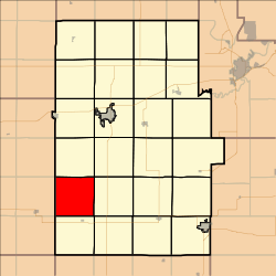 Location in Dickinson County | |
| Coordinates: 38°44′25″N 097°19′01″W / 38.74028°N 97.31694°WCoordinates: 38°44′25″N 097°19′01″W / 38.74028°N 97.31694°W | |
| Country | United States |
| State | Kansas |
| County | Dickinson |
| Area | |
| • Total | 36.07 sq mi (93.43 km2) |
| • Land | 36.01 sq mi (93.26 km2) |
| • Water | 0.06 sq mi (0.17 km2) 0.18% |
| Elevation | 1,240 ft (378 m) |
| Population (2000) | |
| • Total | 152 |
| • Density | 4.2/sq mi (1.6/km2) |
| GNIS feature ID | 0476841 |
Wheatland Township is a township in Dickinson County, Kansas, USA. As of the 2000 census, its population was 152.
Wheatland Township was organized in 1878.[1]
Geography
Wheatland Township covers an area of 36.07 square miles (93.4 km2) and contains no incorporated settlements. According to the USGS, it contains one cemetery, Fairview.
The streams of East Holland Creek and West Holland Creek run through this township.
Further reading
References
External links
Municipalities and communities of Dickinson County, Kansas, United States | ||
|---|---|---|
| Cities | 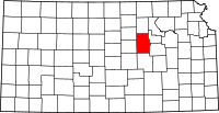 | |
| CDPs | ||
| Unincorporated communities | ||
| Townships | ||
| Footnotes | ‡This populated place also has portions in an adjacent county or counties | |
This article is issued from
Wikipedia.
The text is licensed under Creative Commons - Attribution - Sharealike.
Additional terms may apply for the media files.