Westmoreland Circle
| Westmoreland Circle | |
|---|---|
 1 Westmoreland Circle | |
| Location | |
| Washington, DC and Bethesda, MD | |
| Roads at junction |
Massachusetts Avenue NW Western Avenue Dalecaria Parkway NW Various other local roads |
| Construction | |
| Type | Traffic circle |
| Maintained by | DDOT, MDSHA |
Westmoreland Circle is a traffic circle straddling the border between the U.S. state of Maryland and Washington, D.C. The circle lies at the intersection of Western Avenue, Butterworth Place, Massachusetts Avenue, Dalecarlia Parkway, Wetherill Road, and Dalecarlia Drive. The grass area and trees within the interior of the circle are maintained by and under the jurisdiction of the National Park Service.
There are only two buildings directly on Westmoreland Circle:
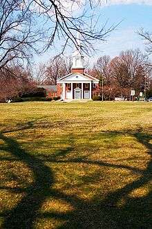
- The Westmoreland Congregational United Church of Christ is located at the circle's northern edge with its address as 1 Westmoreland Circle.
- A Pepco substation is between Massachusetts Avenue and Western Avenue, disguised as a house.[1]
Westmoreland Circle also contains a set of entrance markers erected by the Garden Club of America to denote the Maryland/DC border and a AAA sign directing motorists to Kenwood Golf and Country Club.[2]
References
| Wikimedia Commons has media related to Westmoreland Circle. |
- ↑ Mason, Katrina (29 July 2000). "The Power of Deception: The house on your block that nobody ever seems to enter or exit may just hold a high-voltage secret inside—an electric-power substation for Pepco. es". The Washington Post. p. G1.
- ↑ Kelly, John (8 October 2011). "Old-time road signs survive". The Washington Post. Retrieved 28 August 2017.
Coordinates: 38°56′56″N 77°06′03″W / 38.94892°N 77.10091°W
This article is issued from
Wikipedia.
The text is licensed under Creative Commons - Attribution - Sharealike.
Additional terms may apply for the media files.