Westmead railway station
Westmead | ||||||||||||||||||||||||||||
|---|---|---|---|---|---|---|---|---|---|---|---|---|---|---|---|---|---|---|---|---|---|---|---|---|---|---|---|---|
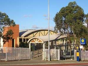 Station front in November 2007 | ||||||||||||||||||||||||||||
| Location | Railway Parade, Westmead | |||||||||||||||||||||||||||
| Coordinates | 33°48′31″S 150°59′17″E / 33.80853056°S 150.9879722°ECoordinates: 33°48′31″S 150°59′17″E / 33.80853056°S 150.9879722°E | |||||||||||||||||||||||||||
| Owned by | RailCorp | |||||||||||||||||||||||||||
| Operated by | Sydney Trains | |||||||||||||||||||||||||||
| Line(s) |
Main Western Rogans Hill | |||||||||||||||||||||||||||
| Distance | 25.16 kilometres from Central | |||||||||||||||||||||||||||
| Platforms | 4 (2 island) | |||||||||||||||||||||||||||
| Tracks | 4 | |||||||||||||||||||||||||||
| Connections | Bus | |||||||||||||||||||||||||||
| Construction | ||||||||||||||||||||||||||||
| Structure type | Ground | |||||||||||||||||||||||||||
| Disabled access | Yes | |||||||||||||||||||||||||||
| Other information | ||||||||||||||||||||||||||||
| Status | Staffed | |||||||||||||||||||||||||||
| Station code | WMD | |||||||||||||||||||||||||||
| Website | Transport for NSW | |||||||||||||||||||||||||||
| History | ||||||||||||||||||||||||||||
| Opened | March 1883 | |||||||||||||||||||||||||||
| Electrified | Yes | |||||||||||||||||||||||||||
| Traffic | ||||||||||||||||||||||||||||
| Passengers (2013) | 7,840 (daily)[1] (Sydney Trains, NSW TrainLink) | |||||||||||||||||||||||||||
| Rank | 30 | |||||||||||||||||||||||||||
| ||||||||||||||||||||||||||||
Westmead railway station is located on the Main Western line, serving the Sydney suburb of Westmead. It is served by Sydney Trains T1 Western Line and T5 Cumberland Line services and NSW TrainLink Blue Mountains Line services.
History
Westmead station opened in March 1883.[2] To the east of the station lies a dive through which one of the eastbound tracks passes. This was opened in 1986 as part of the quadruplication of the Main Western line between Westmead and Granville. It was necessary because west of Westmead the two westbound tracks run adjacent to one another as do the two eastbound tracks. East of Westmead, the lines are configured to run as West/East/West/East.[3]
Between 1922 and 1932, the Rogans Hill line branched from the Main Western line immediately to the west of Westmead station.[4]
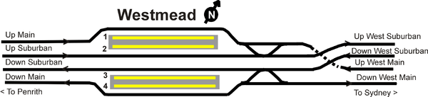
Platforms & services
| Platform | Line | Stopping pattern | Notes |
| 1 | services to Berowra via Gordon | [5] | |
|---|---|---|---|
| services to Leppington | [6] | ||
| 2 | services to Berowra via Gordon | [5] | |
| services to Leppington | [6] | ||
| services to Central | [7] | ||
| 3 | services to Richmond & Emu Plains | [5] | |
| services to Richmond | [6] | ||
| services to Lithgow & Bathurst | [7] | ||
| 4 | services to Richmond & Emu Plains | [5] | |
| services to Richmond | [6] |
| Bus Number | Route | Major Stops/ Stations |
|---|---|---|
| 705 | Parramatta to Blacktown | T- Way, Pendle Hill Station, Toongabbie Station, Seven Hills Station[8] |
| 708 | Parramatta to Blacktown | T- Way, Pendle Hill Station[9] |
| 711 | Parramtta to Blacktown | Public/ Children's Hospital At Westmead, T-way, Wentworthville Station, Seven Hills Station[10] |
| T60 | Parramatta to Castle Hill | T- Way, Winston Hills Mall[11] |
| T61 | Parramatta to Blacktown | T- Way[12] |
| T62 | Parramatta to Castle Hill | T- Way, Norwest Business Park[13] |
| T63 | Parramatta to Rouse Hill Town Centre | T- Way, Stanhope Gardens, Kellyville Ridge[14] |
| T64 | Parramatta to Rouse Hill Town Centre | T- Way, Norwest Business Park[15] |
| T65 | Parramatta to Rouse Hill Town Centre | T- Way[16] |
| T66 | Parramatta to Rouse Hill Town Centre | T- Way[17] |
Westmead station is served by two NightRide routes:
- N70: Penrith to City (Town Hall)[18]
- N71: Richmond to City (Town Hall)[19]
The station will be the future terminus of the Parramatta Light Rail.[20]
Trackplan
References
- ↑ Bureau of Transport Statistics. "Train Statistics 2014" (PDF). Transport NSW. Retrieved 12 July 2018.
- ↑ Westmead Station NSWrail.net
- ↑ "Granville-Westmead Quadruplication" Railway Digest June 1985 page 165
- ↑ "Walking a Forgotten Railway:The Rogans Hill Line Revisited" Australian Railway Historical Society Bulletin Issue 727 May 1998
- 1 2 3 4 "T1: Western line timetable". Transport for NSW.
- 1 2 3 4 "T5: Cumberland line timetable". Transport for NSW.
- 1 2 "Blue Mountains line timetable". Transport for NSW.
- ↑ "Hillsbus route 705". Transport for NSW.
- ↑ "Hillsbus route 708". Transport for NSW.
- ↑ "Hillsbus route 711". Transport for NSW.
- ↑ "Hillsbus route T60". Transport for NSW.
- ↑ "Hillsbus route T61". Transport for NSW.
- ↑ "Hillsbus route T62". Transport for NSW.
- ↑ "Hillsbus route T63". Transport for NSW.
- ↑ "Hillsbus route T64". Transport for NSW.
- ↑ "Hillsbus route T65". Transport for NSW.
- ↑ "Hillsbus route T66". Transport for NSW.
- ↑ "N70 Nightride". Transport for NSW.
- ↑ "N71 Nightride". Transport for NSW.
- ↑ "Parramatta Light Rail preferred network". Transport for NSW. Retrieved 10 March 2016.
External links

- Westmead station details Transport for New South Wales