Washington Camp, Arizona
| Washington Camp, Arizona | |
|---|---|
| Populated place | |
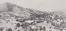 Washington Camp, facing west in 1909. The large mine buildings is the Duquesne Reduction Plant. | |
 Washington Camp, Arizona Location within Santa Cruz County  Washington Camp, Arizona Washington Camp, Arizona (the US) | |
| Coordinates: 31°22′56.83″N 110°40′31.18″W / 31.3824528°N 110.6753278°WCoordinates: 31°22′56.83″N 110°40′31.18″W / 31.3824528°N 110.6753278°W | |
| Country | United States |
| State | Arizona |
| County | Santa Cruz |
| Time zone | Mountain (MST) |
| Post Office opened | May 13, 1880 |
| Post Office closed | June 6, 1890 |
Washington Camp is a populated place in Santa Cruz County, Arizona. Little remains of the historic mining camp and what does is on private property belonging to the community's few remaining residents. The ruins of the ghost town of Duquesne, Arizona, is a mile southeast of Washington Camp.[1][2]
The post office in Washington Camp was first opened on May 13, 1880, and moved to nearby Duquense on June 6, 1890.[1]
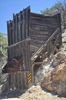
Mine workings (possibly the Kansas Mine) approximately a mile northwest of Washington Camp along the road to Rio Rico.
See also
References
- 1 2 Sherman, James E. (1969). Ghost Towns of Arizona. University of Oklahoma. ISBN 0806108436.
- ↑ John and Bette Bosma (April 2006). "Southwest Arizona Ghost Towns Harshaw, Mowry, Washington Camp, Duquesne, Lochiel" (PDF). Retrieved 2015-01-10.
Municipalities and communities of Santa Cruz County, Arizona, United States | ||
|---|---|---|
| City | 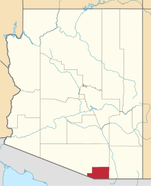 | |
| Town | ||
| CDPs | ||
| Populated places | ||
| Ghost towns | ||
This article is issued from
Wikipedia.
The text is licensed under Creative Commons - Attribution - Sharealike.
Additional terms may apply for the media files.