Patagonia, Arizona
| Patagonia, Arizona | |
|---|---|
| Town | |
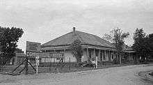
 The post office in Patagonia | |
 Location of Patagonia in Santa Cruz County, Arizona | |
| Coordinates: 31°32′22″N 110°45′22″W / 31.53944°N 110.75611°WCoordinates: 31°32′22″N 110°45′22″W / 31.53944°N 110.75611°W[1] | |
| Country | United States |
| State | Arizona |
| County | Santa Cruz |
| Area[2] | |
| • Total | 1.29 sq mi (3.35 km2) |
| • Land | 1.29 sq mi (3.33 km2) |
| • Water | 0.01 sq mi (0.01 km2) |
| Elevation[1] | 4,058 ft (1,237 m) |
| Population (2010)[3] | |
| • Total | 913 |
| • Estimate (2016)[4] | 878 |
| • Density | 681.68/sq mi (263.29/km2) |
| Time zone | UTC-7 (MST (no DST)) |
| ZIP code | 85624 |
| Area code(s) | 520 |
| FIPS code | 04-53490 |
Patagonia is a town in Santa Cruz County, Arizona, United States. As of the 2010 census Patagonia had a population of 913.[3] Patagonia was formerly a supply center for nearby mines and ranches. It is a tourist destination, retirement community and arts and crafts center.
Geography
The town is located in the valley of Sonoita Creek between the Santa Rita Mountains to the north and the Patagonia Mountains to the south. State route 82 passes through the town. Nogales lies to the southwest and Sonoita to the northeast. The old mining camps (now ghost towns) of Harshaw, Duquesne and Lochiel lie to the southeast along the eastern margin of the Patagonia Mountains. The high San Rafael Valley also lies to the southeast. Patagonia Lake State Park around Patagonia Lake lies about six miles southwest of the town.[5]
According to the United States Census Bureau, the town has a total area of 1.3 square miles (3.3 km2), all land.
Demographics
| Historical population | |||
|---|---|---|---|
| Census | Pop. | %± | |
| 1950 | 700 | — | |
| 1960 | 540 | −22.9% | |
| 1970 | 630 | 16.7% | |
| 1980 | 980 | 55.6% | |
| 1990 | 888 | −9.4% | |
| 2000 | 881 | −0.8% | |
| 2010 | 913 | 3.6% | |
| Est. 2016 | 878 | [4] | −3.8% |
| U.S. Decennial Census[6] | |||
As of the census[7] of 2000, there were 881 people, 404 households, and 239 families residing in the town. The population density was 738.7 people per square mile (285.8/km²). There were 498 housing units at an average density of 417.5 per square mile (161.6/km²). The racial makeup of the town was 86.49% White, 0.91% Native American, 0.45% Asian, 10.56% from other races, and 1.59% from two or more races. 39.50% of the population were Hispanic or Latino of any race.
There were 404 households out of which 22.8% had children under the age of 18 living with them, 47.0% were married couples living together, 8.9% had a female householder with no husband present, and 40.8% were non-families. 35.1% of all households were made up of individuals and 15.3% had someone living alone who was 65 years of age or older. The average household size was 2.18 and the average family size was 2.85.
In the town, the population was spread out with 20.9% under the age of 18, 5.3% from 18 to 24, 20.3% from 25 to 44, 32.1% from 45 to 64, and 21.3% who were 65 years of age or older. The median age was 47 years. For every 100 females there were 87.8 males. For every 100 females age 18 and over, there were 85.9 males.
The median income for a household in the town was $25,795, and the median income for a family was $31,000. Males had a median income of $25,625 versus $24,844 for females. The per capita income for the town was $15,325. About 18.0% of families and 25.1% of the population were below the poverty line, including 36.1% of those under age 18 and 17.2% of those age 65 or over.
As of 2010 Patagonia had a population of 913. The racial and ethnic composition of the population was 55.9% non-Hispanic white, 0.2% African American, 2.2% Native American, 0.1% non-Hispanics reporting some other race, 1.1% reporting two or more races and 42.4% Hispanic or Latino.[8]
Notable residents
- Philip Caputo, author
- Jim Harrison, U.S. novelist, poet, and food critic, who famously called Patagonia "preposterously beautiful"
- Gary Nabhan, prizewinning writer and ethnobotanist.
See also
References
- 1 2 U.S. Geological Survey Geographic Names Information System: Patagonia, Arizona
- ↑ "2016 U.S. Gazetteer Files". United States Census Bureau. Retrieved Jul 18, 2017.
- 1 2 "American FactFinder". United States Census Bureau. Retrieved 2014-08-23.
- 1 2 "Population and Housing Unit Estimates". Retrieved June 9, 2017.
- ↑ Arizona Atlas & Gazetteer, DeLorme, 4th ed., 2001 ISBN 0-89933-325-7
- ↑ "Census of Population and Housing". Census.gov. Retrieved June 4, 2016.
- ↑ "American FactFinder". United States Census Bureau. Retrieved 2008-01-31.
- ↑ 2010 population chart for Patagonia
External links
| Wikivoyage has a travel guide for Patagonia (Arizona). |
![]()
Municipalities and communities of Santa Cruz County, Arizona, United States | ||
|---|---|---|
| City | 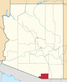 | |
| Town | ||
| CDPs | ||
| Populated places | ||
| Ghost towns | ||