Washington's 3rd congressional district
| Washington's 3rd congressional district | |
|---|---|
 | |
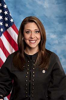
| Current Representative | Jaime Herrera Beutler (R–Camas) |
| Population (2000) | 654,898 |
| Median income | 44,426 |
| Ethnicity |
|
| Cook PVI | R+4[1] |
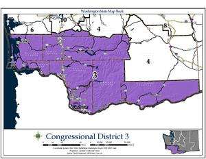
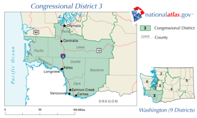
Washington's 3rd congressional district encompasses the southernmost portion of western and central Washington. It includes the counties of Lewis, Pacific, Wahkiakum, Cowlitz, Clark, Skamania, and Klickitat, and a small sliver of southern Thurston county. The 3rd District is represented by Republican Jaime Herrera Beutler.
Established after the 1900 census, the Third District was represented by Democrats for most of the latter half of the 20th century, until Rep. Jolene Unsoeld was defeated by Republican Linda Smith as part of the Republican Revolution of 1994. Smith retired after two terms, and was succeeded by Democrat Brian Baird. Baird announced he wouldn't run for re-election in 2010, with Republican Jaime Herrera Beutler winning the now open seat in the 2010 general election 53%-47% against Democratic representative Denny Heck, who was subsequently elected in Washington's 10th congressional district. Herrera Beutler retained her seat 60%-40% over Democrat Jon T. Haugen in 2012. In 2014, she beat Democrat Bob Dingethal by 61.5% to 38.5%.
In presidential elections, the 3rd District is rather competitive. It is the only part of western Washington that didn't swing heavily to the Democrats during the 1990s, and is one of the few districts in the country that cannot be considered safe for either party. It is home to Lewis County, far and away the most conservative county in western Washington. Additionally, most of the district is located in the Portland, Oregon, market; voting patterns there are somewhat different than those in the areas closer to Seattle. George W. Bush narrowly carried the district in 2000 with 48% of the vote and again in 2004 with 50%. The district swung Democratic in 2008, giving Barack Obama 52% of the vote and 46% to John McCain. However, redistricting (see below) extended the district further east and made it slightly more Republican than its predecessor; had the current boundaries been in effect for the 2008 election, Obama would have only defeated McCain by 50.9 percent to 47.1 percent. In 2012, it gave Mitt Romney 49.6% to Obama's 47.9%. In the 2016 presidential election, Republican nominee Donald Trump won the district 49.9% to Hillary Clinton's 42.5%.
Recent results from presidential races
| Year | Office | Results |
|---|---|---|
| 1952 | President | Eisenhower 54 - 46% |
| 1956 | President | Eisenhower 52 - 48% |
| 1960 | President | Kennedy 50 - 50% |
| 1964 | President | Johnson 70 - 30% |
| 1968 | President | Humphrey 52 - 42% |
| 1972 | President | Nixon 58 - 42% |
| 1976 | President | Carter 50 - 46% |
| 1980 | President | Reagan 50 - 38% |
| 1984 | President | Reagan 53 - 45% |
| 1988 | President | Dukakis 51 - 47% |
| 1992 | President | Clinton 42 - 33% |
| 1996 | President | Clinton 49 - 38% |
| 2000 | President | Bush 48 - 47% |
| 2004 | President | Bush 50 - 48% |
| 2008 | President | Obama 52 - 46% |
| 2012 | President | Romney 49 - 47%[2] |
| 2016 | President | Trump 49 - 42%[2] |
List of representatives
| Representative | Party | Term | Electoral history |
|---|---|---|---|
| District created | March 4, 1909 | [Data unknown/missing.] | |
 |
Republican | March 4, 1909 – March 3, 1911 |
[Data unknown/missing.] |
.jpg) |
Republican | March 4, 1911 – March 3, 1915 |
Redistricted to the 4th district |
 |
Republican | March 4, 1915 – March 3, 1933 |
Redistricted from the 2nd district |
 |
Democratic | March 4, 1933 – January 3, 1943 |
[Data unknown/missing.] |
.jpg) |
Republican | January 3, 1943 – January 3, 1945 |
[Data unknown/missing.] |
 |
Democratic | January 3, 1945 – January 3, 1947 |
[Data unknown/missing.] |
|
Republican | January 3, 1947 – April 18, 1947 |
Died |
| Vacant | April 18, 1947 – July 7, 1947 | ||
 |
Republican | July 7, 1947 – March 28, 1960 |
Died |
| Vacant | March 28, 1960 – November 8, 1960 | ||
 |
Democratic | November 8, 1960 – December 31, 1974 |
[Data unknown/missing.] |
| Vacant | December 31, 1974 – January 3, 1975 | ||
 |
Democratic | January 3, 1975 – January 3, 1989 |
[Data unknown/missing.] |
 |
Democratic | January 3, 1989 – January 3, 1995 |
[Data unknown/missing.] |
 |
Republican | January 3, 1995 – January 3, 1999 |
[Data unknown/missing.] |
 |
Democratic | January 3, 1999 – January 3, 2011 |
[Data unknown/missing.] |
 |
Republican | January 3, 2011 – present |
[Data unknown/missing.] |
Census 2010 Redistricting
The Washington State Redistricting Commission is charged with adjusting congressional and legislative district boundaries after each decennial census. Given Washington State's growth over the previous decade, Washington gained an additional congressional district for the 113th congress. The third district needed to lose 106,894 people in the redistricting process in order to meet the ideal population of 672,454.[3] On September 13, 2011, the four voting commissioners on the Redistricting Commission submitted draft proposals for the congressional map. All four draft proposals left the entirety of Lewis, Wahkiakum, Cowlitz, and Clark Counties, and all or most of Skamania county in the 3rd district. In addition, each proposal added population from one or more of Pacific, Thurston, Pierce, or Klickitat counties.[4] [5] [6] [7]
The final approved map for the 3rd district includes the entirety of Klickitat, Skamania, Clark, Cowlitz, Wahkiakum, Pacific, and Lewis counties, with the extreme southern part of Thurston county south of highway 12, Washington State Route 507, and the Vail Cut Off Road.[8]
See also
References
- Specific
- ↑ "Partisan Voting Index – Districts of the 115th Congress" (PDF). The Cook Political Report. April 7, 2017. Retrieved April 7, 2017.
- 1 2 "Daily Kos Elections' presidential results by congressional district for 2016, 2012, and 2008". dailykos.com. Retrieved 13 April 2018.
- ↑ "2010 Congressional Malapportionment Report" (PDF). Washington State Redistricting Commission. Retrieved 14 Sep 2011.
- ↑ Ceis, Tim. "Draft Congressional Plan #1 - Commissioner Ceis - September 13, 2011" (PDF). Washington State Redistricting Commission. Retrieved 14 Sep 2011.
- ↑ Gorton, Slade. "Draft Congressional Plan #1 - Commissioner Gorton - September 13, 2011" (PDF). Washington State Redistricting Commission. Retrieved 14 Sep 2011.
- ↑ Foster, Dean. "Draft Congressional Plan #1 - Commissioner Foster - September 13, 2011" (PDF). Washington State Redistricting Commission. Retrieved 14 Sep 2011.
- ↑ Huff, Tom. "Draft Congressional Plan #1 - Commissioner Huff - September 13, 2011" (PDF). Washington State Redistricting Commission. Retrieved 14 Sep 2011.
- ↑ "Congressional District 3" (PDF). Washington Redistricting Commission. Retrieved 2012-05-06.
- General
- Martis, Kenneth C. (1989). The Historical Atlas of Political Parties in the United States Congress. New York: Macmillan Publishing Company.
- Martis, Kenneth C. (1982). The Historical Atlas of United States Congressional Districts. New York: Macmillan Publishing Company.
- Congressional Biographical Directory of the United States 1774–present Their final version was approved and sent to the legislature on January 1, 2012.