Walnut Grove, Kansas
| Walnut Grove, Kansas | |
|---|---|
| Coordinates: 39°21′02″N 98°03′36″W / 39.35056°N 98.06000°WCoordinates: 39°21′02″N 98°03′36″W / 39.35056°N 98.06000°W | |
| Country | United States |
| State | Kansas |
| County | Mitchell |
| Elevation | 1,489 ft (454 m) |
| Time zone | UTC-6 (Central (CST)) |
| • Summer (DST) | UTC-5 (CDT) |
| GNIS feature ID | 482031[1] |


Walnut Grove was a small settlement in Mitchell County, Kansas, United States.
History
There were two settlements in Mitchell County with the name Walnut Grove. The first was in Hayes Township with a post office from 1876 to 1881.[2] In 1886, Walnut Grove in Bloomfield Township was issued a post office. This post office was renamed Walnutgrove in 1894, then discontinued in 1901.[3]
References
- ↑ "US Board on Geographic Names". United States Geological Survey. 1984-07-01. Retrieved 2017-12-30.
- ↑ "Kansas Post Offices, 1828-1961". Kansas Historical Society. Retrieved 2017-12-30.
- ↑ "Kansas Post Offices, 1828-1961". Kansas Historical Society. Retrieved 2017-12-30.
Municipalities and communities of Mitchell County, Kansas, United States | ||
|---|---|---|
| Cities | 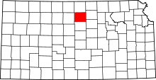 | |
| CDP | ||
| Unincorporated community | ||
| Ghost towns | ||
| Townships |
| |
| Footnotes | ‡This populated place also has portions in an adjacent county or counties | |
This article is issued from
Wikipedia.
The text is licensed under Creative Commons - Attribution - Sharealike.
Additional terms may apply for the media files.