Cawker City, Kansas
| Cawker City, Kansas | |
|---|---|
| City | |
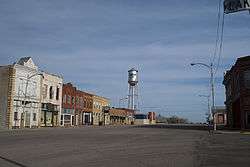 Water Tower and Downtown (2012) (view from near the Ball of Twine) | |
 Location within Mitchell County and Kansas | |
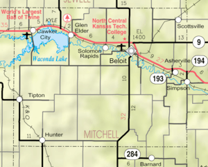 KDOT map of Mitchell County (legend) | |
| Coordinates: 39°30′32″N 98°26′2″W / 39.50889°N 98.43389°WCoordinates: 39°30′32″N 98°26′2″W / 39.50889°N 98.43389°W | |
| Country | United States |
| State | Kansas |
| County | Mitchell |
| Government | |
| • Mayor | Steve Bader |
| Area[1] | |
| • Total | 1.00 sq mi (2.59 km2) |
| • Land | 1.00 sq mi (2.59 km2) |
| • Water | 0 sq mi (0 km2) |
| Elevation | 1,496 ft (456 m) |
| Population (2010)[2] | |
| • Total | 469 |
| • Estimate (2016)[3] | 451 |
| • Density | 470/sq mi (180/km2) |
| Time zone | UTC-6 (CST) |
| • Summer (DST) | UTC-5 (CDT) |
| ZIP code | 67430 |
| Area code | 785 |
| FIPS code | 20-11175 [4] |
| GNIS ID | 0472174 [5] |
| Website | City Website |
Cawker City is a city in Mitchell County, Kansas, United States. As of the 2010 census, the city population was 469.[6] The city is located along the north shore of Waconda Lake and Glen Elder State Park.
It is one of several places claiming to be home of the largest ball of twine in the world.[7][8][9]
History
Cawker City was founded in 1870.[10] According to tradition, Colonel E. H. Cawker won naming rights for the town with a winning hand at poker.[11] Cawker City was incorporated as a city in 1874.[12] The first post office in Cawker City was established in June 1870.[13]
The city previously served many families living on small farms. A resident stated that Cawker City had three grocery stores in the 1960s. By 2017 the community had no grocery stores. Many young adults were leaving to find work elsewhere. In the area family sizes decreased and farm plot sizes increased. These factors caused the community's population to decline.[14]
Geography
Cawker City is located at 39°30′32″N 98°26′2″W / 39.50889°N 98.43389°W (39.508835, -98.433842).[15] According to the United States Census Bureau, the city has a total area of 1.00 square mile (2.59 km2), all of it land.[1] The city is located along the north shore of Waconda Lake.
Demographics
| Historical population | |||
|---|---|---|---|
| Census | Pop. | %± | |
| 1880 | 1,039 | — | |
| 1890 | 898 | −13.6% | |
| 1900 | 816 | −9.1% | |
| 1910 | 870 | 6.6% | |
| 1920 | 788 | −9.4% | |
| 1930 | 739 | −6.2% | |
| 1940 | 657 | −11.1% | |
| 1950 | 691 | 5.2% | |
| 1960 | 686 | −0.7% | |
| 1970 | 726 | 5.8% | |
| 1980 | 640 | −11.8% | |
| 1990 | 588 | −8.1% | |
| 2000 | 521 | −11.4% | |
| 2010 | 469 | −10.0% | |
| Est. 2016 | 451 | [3] | −3.8% |
| U.S. Decennial Census | |||
2010 census
As of the census[2] of 2010, there were 469 people, 244 households, and 132 families residing in the city. The population density was 469.0 inhabitants per square mile (181.1/km2). There were 315 housing units at an average density of 315.0 per square mile (121.6/km2). The racial makeup of the city was 97.0% White, 0.2% African American, 0.2% Asian, 0.9% from other races, and 1.7% from two or more races. Hispanic or Latino of any race were 2.1% of the population.
There were 244 households of which 19.3% had children under the age of 18 living with them, 40.6% were married couples living together, 7.0% had a female householder with no husband present, 6.6% had a male householder with no wife present, and 45.9% were non-families. 41.8% of all households were made up of individuals and 19.6% had someone living alone who was 65 years of age or older. The average household size was 1.92 and the average family size was 2.52.
The median age in the city was 50.1 years. 18.6% of residents were under the age of 18; 4.5% were between the ages of 18 and 24; 17.9% were from 25 to 44; 32.4% were from 45 to 64; and 26.7% were 65 years of age or older. The gender makeup of the city was 51.4% male and 48.6% female.
2000 census

As of the census[4] of 2000, there were 521 people, 261 households, and 151 families residing in the city. The population density was 525.9 people per square mile (203.2/km²). There were 335 housing units at an average density of 338.2 per square mile (130.7/km²). The racial makeup of the city was 97.50% White, 0.19% African American, 1.73% Native American, 0.38% from other races, and 0.19% from two or more races. Hispanic or Latino of any race were 0.77% of the population.
There were 261 households out of which 17.6% had children under the age of 18 living with them, 48.7% were married couples living together, 6.9% had a female householder with no husband present, and 41.8% were non-families. 37.9% of all households were made up of individuals and 21.5% had someone living alone who was 65 years of age or older. The average household size was 2.00 and the average family size was 2.61.
In the city, the population was spread out with 18.0% under the age of 18, 5.0% from 18 to 24, 19.8% from 25 to 44, 27.4% from 45 to 64, and 29.8% who were 65 years of age or older. The median age was 49 years. For every 100 females, there were 98.9 males. For every 100 females age 18 and over, there were 97.7 males.
The median income for a household in the city was $24,833, and the median income for a family was $30,769. Males had a median income of $25,893 versus $17,813 for females. The per capita income for the city was $13,693. About 12.3% of families and 11.6% of the population were below the poverty line, including 14.7% of those under age 18 and 8.3% of those age 65 or over.
Economy
In 2017, a Dollar General store opened, giving residents a local shopping option for food.[16]
Attractions

- Cawker City is one of several places claiming to be home of the largest ball of twine in the world. Each year a twine-a-thon is held in August to increase the size of the ball.
- Waconda Lake
Fictional cultural references
In the 1980 MGM movie "Hero at Large," the main character, Steve Nichols, hails from Cawker City. Three times during the movie the town is mentioned and there is a green and white Cawker City school banner hanging on the wall.
Cawker City is mentioned in the 2008 young-adult novel Paper Towns.
Cawker City and The World's Largest Ball Of Twine are both featured in Sharknado: The 4th Awakens.
Education
Cawker City is served by USD 272 Waconda. The district elementary school is Lakeside Elementary school in Cawker City. The district high school is Lakeside High School (Kansas)|Lakeside High School in Downs with the mascot Knights.[17]
School unification combined Cawker City High School with Glen Elder High School in 1971 forming Waconda East High School. The Waconda East High School mascot was Vikings. Waconda East High School was then unified with Downs High School in 2003 forming USD 272.[18]
Prior to school unification, the Cawker City High School mascot was Cawker City Pirates.[19]
The elementary building was formerly known as Cawker City Elementary School.[20] Its name changed to the current one in 2015.[21]
Notable people
- Merwin Coad, Iowa politician
- Claire Windsor, silent film actress.
References
- 1 2 "US Gazetteer files 2010". United States Census Bureau. Archived from the original on 2012-01-24. Retrieved 2012-07-06.
- 1 2 "American FactFinder". United States Census Bureau. Retrieved 2012-07-06.
- 1 2 "Population and Housing Unit Estimates". Retrieved June 9, 2017.
- 1 2 "American FactFinder". United States Census Bureau. Archived from the original on 2013-09-11. Retrieved 2008-01-31.
- ↑ "US Board on Geographic Names". United States Geological Survey. 2007-10-25. Retrieved 2008-01-31.
- ↑ "2010 City Population and Housing Occupancy Status". U.S. Census Bureau. Archived from the original on July 21, 2011. Retrieved October 10, 2011.
- ↑ Heim, Michael (2007). Exploring Kansas Highways. p. 78.
- ↑ Cawker City wins the ball game with massive sphere of twine; The Wichita Eagle; September 28, 2014.
- ↑ Twisted: The Battle to Be the World's Largest Ball of Twine; The Atlantic; September 9, 2014.
- ↑ Kansas State Historical Society (1916). Biennial Report of the Board of Directors of the Kansas State Historical Society. Kansas State Printing Plant. p. 241.
- ↑ "Origin of Town Names" (PDF). Solomon Valley Highway 24 Heritage Alliance. p. 2. Retrieved 9 April 2018.
- ↑ Blackmar, Frank Wilson (1912). Kansas: A Cyclopedia of State History, Embracing Events, Institutions, Industries, Counties, Cities, Towns, Prominent Persons, Etc. Standard Publishing Company. p. 301.
- ↑ "Kansas Post Offices, 1828-1961 (archived)". Kansas Historical Society. Archived from the original on October 9, 2013. Retrieved 10 June 2014.
- ↑ "A Thriving Rural Town's Winning Formula Faces New Threats Under Trump Administration". National Public Radio. 2017-02-19. Retrieved 2017-02-25.
- ↑ "US Gazetteer files: 2010, 2000, and 1990". United States Census Bureau. 2011-02-12. Retrieved 2011-04-23.
- ↑ Morris, Frank (December 11, 2017). "How Dollar General Is Transforming Rural America". NPR.org. Retrieved 2017-12-12.
- ↑ "Waconda USD 272". USD 272. Retrieved 7 January 2017.
- ↑ "History of Glen Elder" (PDF). Solomon Valley Highway 24 Heritage Foundation. Retrieved 30 December 2016.
- ↑ "Cawker City Returns Three", The Salina Journal, Cawker City Returns Three, p.11.
- ↑ Home. Waconda USD 272. April 9, 2002. Retrieved on February 25, 2017.
- ↑ Page, Dan (2017-02-25). "Waconda District To Use Funds For Elementary Curriculum". Sunflower State Radio. Retrieved 2017-02-25.
External links
| Wikimedia Commons has media related to Cawker City, Kansas. |
- City
- Schools
- USD 272, local school district
- Attractions
- Pictures
- Historic Images of Cawker City, Wichita State University Library
- Maps
- Cawker City Map, KDOT
Municipalities and communities of Mitchell County, Kansas, United States | ||
|---|---|---|
| Cities | 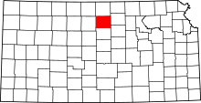 | |
| CDP | ||
| Unincorporated community | ||
| Ghost towns | ||
| Townships |
| |
| Footnotes | ‡This populated place also has portions in an adjacent county or counties | |