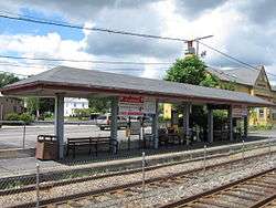
Wakefield station (MBTA)
WAKEFIELD | |||||||||||
|---|---|---|---|---|---|---|---|---|---|---|---|
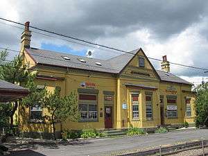 Wakefield Upper Depot in 2010 | |||||||||||
| Location |
225 North Avenue Wakefield, Massachusetts | ||||||||||
| Coordinates | 42°30′8.0″N 71°4′32.3″W / 42.502222°N 71.075639°WCoordinates: 42°30′8.0″N 71°4′32.3″W / 42.502222°N 71.075639°W | ||||||||||
| Owned by | Town of Wakefield | ||||||||||
| Line(s) | Western Route | ||||||||||
| Platforms | 2 side platforms | ||||||||||
| Tracks | 2 | ||||||||||
| Connections |
| ||||||||||
| Construction | |||||||||||
| Parking | 117 spaces ($2.00 daily) | ||||||||||
| Bicycle facilities | 6 spaces | ||||||||||
| Other information | |||||||||||
| Fare zone | 2 | ||||||||||
| History | |||||||||||
| Rebuilt | 1889 | ||||||||||
| Traffic | |||||||||||
| Passengers (2013) | 682 (weekday inbound average)[1] | ||||||||||
| Services | |||||||||||
| |||||||||||
|
Wakefield Upper Depot | |||||||||||
  | |||||||||||
| Location |
27-29 Tuttle Street, Wakefield, Massachusetts, USA | ||||||||||
| Built | 1889 | ||||||||||
| Architectural style | Panel Brick | ||||||||||
| MPS | Wakefield MRA | ||||||||||
| NRHP reference # | 89000719[2] | ||||||||||
| Added to NRHP | July 06, 1989 | ||||||||||
Wakefield is an MBTA Commuter Rail station in Wakefield, Massachusetts served by the Haverhill Line. The station is not accessible.
History
Rail service was introduced to Wakefield in 1845, primarily through the efforts of Thomas Spaulding, a local businessman. The surviving 19th-century Wakefield Station was built in 1889 by the Boston and Maine Railroad, and served as Wakefield Upper Depot, a major stop in the town, which in 1893 had six stations with as many as 60 trains per day. The building is architecturally distinctive in the town as an example of Panel Brick architecture, and was originally augmented by a baggage depot which stood to its south. The building now houses commercial activity, and was listed on the National Register of Historic Places in 1989.[2][3] The former Lynnfield Centre depot from the Newburyport Railroad line, closed in 1959, is located at the north end of the station. Center Depot, another NRHP-listed station, is about 0.5 miles (0.80 km) to the east.
Bus connections
The station is served by one MBTA Bus route on North Avenue:
- 137 Reading Depot - Malden Station via North Avenue, Wakefield, Melrose & Oak Grove Station
Route 136 runs on Main Street about 0.25 miles (0.40 km) to the east.
References
- ↑ "Ridership and Service Statistics" (PDF) (14th ed.). Massachusetts Bay Transportation Authority. 2014.
- 1 2 National Park Service (2008-04-15). "National Register Information System". National Register of Historic Places. National Park Service.
- ↑ "NRHP nomination and MACRIS inventory record for Wakefield Upper Depot". Commonwealth of Massachusetts. Retrieved 2017-12-01.
External links
![]()
| Topics |  | ||||||||||||||||
|---|---|---|---|---|---|---|---|---|---|---|---|---|---|---|---|---|---|
| Lists by county | |||||||||||||||||
| Lists by city |
| ||||||||||||||||
| Other lists | |||||||||||||||||
| |||||||||||||||||