Vinkivtsi Raion
| Vinkivtsi Raion Віньковецький район | |||
|---|---|---|---|
| Raion | |||
| |||
 | |||
| Coordinates: 49°01′59″N 27°14′01″E / 49.03306°N 27.23361°ECoordinates: 49°01′59″N 27°14′01″E / 49.03306°N 27.23361°E | |||
| Country |
| ||
| Region | Khmelnytskyi Oblast | ||
| Established | March 7, 1923 | ||
| Admin. center | Vinkivtsi | ||
| Subdivisions |
List
| ||
| Government | |||
| • Governor | Anatoliy Panasevych[1] | ||
| Area | |||
| • Total | 653 km2 (252 sq mi) | ||
| Elevation, at Vinkivtsi | 290 m (950 ft) | ||
| Population (2012) | |||
| • Total |
| ||
| Time zone | UTC+2 (EET) | ||
| • Summer (DST) | UTC+3 (EEST) | ||
| Postal index | 32500—32537 | ||
| Area code | +380 3846 | ||
| Website | http://vin.km.ua | ||
Vinkivtsi Raion (Ukrainian: Віньковецький район, Vin'kovets'kyi raion) is one of the 20 administrative raions (a district) of the Khmelnytskyi Oblast in western Ukraine. Its administrative center is located in the urban-type settlement of Vinkivtsi. Its population was 31,058 as of the 2001 Ukrainian Census[2] and 25,630 as of 2012.
Geography
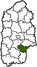
The Vinkivtsi Raion is located in the eastern part of the Khmelnytskyi Oblast, corresponding to the modern-day boundaries of the Podolia historical region. It borders upon the neighboring Bar Raion of Vinnytsia Oblast. Its total area constitutes 653 square kilometres (252 sq mi). Accordingly, the district occupies 3.39 percent of the oblast's total area, and 2 percent of its population.[3]
History
The Vinkivtsi Raion was first established on March 7, 1923 as part of a full-scale administrative reorganization of the Ukrainian Soviet Socialist Republic.[2] On October 31, 1927, its administrative center Vinkivtsi was renamed Zatonsk in honor of Volodymyr Zatonsky, a member of the Academy of Sciences of the Ukrainian SSR.[3] Accordingly, the district was renamed to the Zatonskyi Raion (Ukrainian: Затонський район),[2] a name which it kept until 1938 when both the town and district reverted to their original names.[3]
The Vinkivtsi Raion existed up until it was dissolved in on December 30, 1962.[3] After it was dissolved, its territory was at first annexed by the neighboring Yarmolyntsi Raion; its former territory was later divided between the Nova Ushytsia and Derazhnia Raions.[3] A decree of the Presidium of the Supreme Soviet dated December 8, 1966 again re-established the Vinkivtsi Raion.[3]
Administrative divisions
The Vinkivtsi Raion is divided in a way that follows the general administrative scheme in Ukraine. Local government is also organized along a similar scheme nationwide. Consequently, raions are subdivided into councils, which are the prime level of administrative division in the country.
Each of the raion's urban localities administer their own councils, often containing a few other villages within its jurisdiction. However, only a handful of rural localities are organized into councils, which also may contain a few villages within its jurisdiction.
Accordingly, the Vinkivtsi Raion is divided into:[2]
- 1 settlement council—made up of the urban-type settlement of Vinkivtsi (administrative center)
- 17 village councils
Overall, the raion has a total of 36 populated localities, consisting of one urban-type settlement, and 35 villages.[2]
References
- ↑ "Leaders of the administration". Vinkivtsi Raion State Administration (in Ukrainian). Archived from the original on 19 August 2013. Retrieved 30 January 2013.
- 1 2 3 4 5 "Vinkivtsi Raion, Khmelnytskyi Oblast". Regions of Ukraine and their Structure (in Ukrainian). Verkhovna Rada of Ukraine. Retrieved 30 January 2013.
- 1 2 3 4 5 6 "Main Page". Vinkivtsi Raion State Administration (in Ukrainian). Archived from the original on 22 May 2013. Retrieved 30 January 2013.
External links
| Wikimedia Commons has media related to Vinkivtsi Raion. |
- "Main Page". Vinkivtsi Raion State Administration (in Ukrainian). Archived from the original on 22 May 2013. Retrieved 30 January 2013.
Administrative geographic location | |
|---|---|
| Urban-type settlements | ||
|---|---|---|
| Villages |
| |
| Raions | |||||
|---|---|---|---|---|---|
| Cities |
| ||||
| |||||