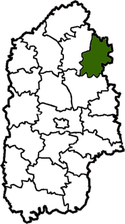
Polonne Raion
| Polonne Raion Полонський район | |||
|---|---|---|---|
| Raion | |||
| |||
 | |||
| Country |
| ||
| Region | Khmelnytskyi Oblast | ||
| Established | 1923 | ||
| Admin. center | Polonne | ||
| Subdivisions |
List
| ||
| Government | |||
| • Governor | Alexander M. Dekhtyaruk | ||
| Area | |||
| • Total | 866 km2 (334 sq mi) | ||
| Population | |||
| • Total | 46,367 | ||
| • Density | 54/km2 (140/sq mi) | ||
| Time zone | UTC+2 (EET) | ||
| • Summer (DST) | UTC+3 (EEST) | ||
| Postal index | 30500—30545 | ||
| Area code | 380-3843 | ||
| Website |
poladm | ||
Polonne Raion (Ukrainian: Полонський район) is a raion in Khmelnytskyi Oblast in Ukraine. Its administrative center is Polonne. Its population is 46 367 inhabitants (January 1, 2011).[1] It was established in 1923. 1 city (Polonne), 1 urban-type settlements and 45 villages are located in Polonne Raion.
Geography
Polonne Raion is a part of Volhynia. It is one out 20 Raions of Khmelnytskyi Oblast. This is a small Raion it occupies 15th place among the districts of the region (866 km² corresponds to 4,2% of the total area of Khmelnytskyi Oblast).
Polonne Raion is east of Shepetivka Raion, north of Starokostiantyniv Raion, west and south-west of Zhytomyr Oblast (Liubar Raion, Romaniv Raion and Baranivka Raion). The Sluch, Homora, Derevychka, Smilka and other rivers flow through the district. There is a rail line through the districts (Shepetivka—Polonne—Berdychiv).
History
From 1923 to 1932 the district was part of the Shepetivka region, then from 1932 to 1937 it was part of the Vinnytsia region. Following that from 1937 to 1954 it was part of the Kamenets Podolsk region. Since 1954 it has been part of the Khmelnytskyi region. Finally Polonskyi Raion was formed December 8, 1966.[2]
References
External links
- www.polonne.com (in Ukrainian)
- Хмельницька обласна рада. Passport Polonskyi Raion (doc) (in Ukrainian)

Administrative geographic location | |
|---|---|
| Raions | |||||
|---|---|---|---|---|---|
| Cities |
| ||||
| |||||