Villars-le-Sec
| Villars-le-Sec | ||
|---|---|---|
| Commune | ||
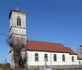 The church of the Nativity of Our Lady | ||
| ||
 Villars-le-Sec Location within Bourgogne-Franche-Comté region  Villars-le-Sec | ||
| Coordinates: 47°27′18″N 6°59′29″E / 47.455°N 6.9914°ECoordinates: 47°27′18″N 6°59′29″E / 47.455°N 6.9914°E | ||
| Country | France | |
| Region | Bourgogne-Franche-Comté | |
| Department | Territoire de Belfort | |
| Arrondissement | Belfort | |
| Canton | Delle | |
| Intercommunality | Sud Territoire | |
| Government | ||
| • Mayor (2014–2020) | Laurent Brochet | |
| Area1 | 3.05 km2 (1.18 sq mi) | |
| Population (2006)2 | 144 | |
| • Density | 47/km2 (120/sq mi) | |
| Time zone | UTC+1 (CET) | |
| • Summer (DST) | UTC+2 (CEST) | |
| INSEE/Postal code | 90105 /90100 | |
| Elevation | 519–621 m (1,703–2,037 ft) | |
|
1 French Land Register data, which excludes lakes, ponds, glaciers > 1 km2 (0.386 sq mi or 247 acres) and river estuaries. 2 Population without double counting: residents of multiple communes (e.g., students and military personnel) only counted once. | ||

Villars-le-Sec is a commune in the Territoire de Belfort department in Bourgogne-Franche-Comté in northeastern France.
See also
| Wikimedia Commons has media related to Villars-le-Sec. |
References
This article is issued from
Wikipedia.
The text is licensed under Creative Commons - Attribution - Sharealike.
Additional terms may apply for the media files.