Romagny-sous-Rougemont
| Romagny-sous-Rougemont | ||
|---|---|---|
| Commune | ||
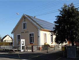 Town hall-school | ||
| ||
 Romagny-sous-Rougemont Location within Bourgogne-Franche-Comté region  Romagny-sous-Rougemont | ||
| Coordinates: 47°43′06″N 6°58′06″E / 47.7183°N 6.9683°ECoordinates: 47°43′06″N 6°58′06″E / 47.7183°N 6.9683°E | ||
| Country | France | |
| Region | Bourgogne-Franche-Comté | |
| Department | Territoire de Belfort | |
| Arrondissement | Belfort | |
| Canton | Giromagny | |
| Intercommunality | Pays sous Vosgien | |
| Government | ||
| • Mayor (2014–2020) | Jeanine Genevois | |
| Area1 | 2.47 km2 (0.95 sq mi) | |
| Population (2006)2 | 221 | |
| • Density | 89/km2 (230/sq mi) | |
| Time zone | UTC+1 (CET) | |
| • Summer (DST) | UTC+2 (CEST) | |
| INSEE/Postal code | 90086 /90110 | |
| Elevation | 390–538 m (1,280–1,765 ft) | |
|
1 French Land Register data, which excludes lakes, ponds, glaciers > 1 km2 (0.386 sq mi or 247 acres) and river estuaries. 2 Population without double counting: residents of multiple communes (e.g., students and military personnel) only counted once. | ||

Romagny-sous-Rougemont is a commune in the Territoire de Belfort department in Bourgogne-Franche-Comté in northeastern France.
See also
| Wikimedia Commons has media related to Romagny-sous-Rougemont. |
References
This article is issued from
Wikipedia.
The text is licensed under Creative Commons - Attribution - Sharealike.
Additional terms may apply for the media files.