Valdoie
| Valdoie | ||
|---|---|---|
| Commune | ||
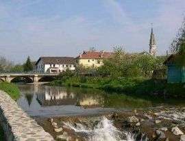 A view of the bridge crossing the river and the church tower, visible at the bottom right | ||
| ||
 Valdoie Location within Bourgogne-Franche-Comté region  Valdoie | ||
| Coordinates: 47°40′02″N 6°50′31″E / 47.6672°N 6.8419°ECoordinates: 47°40′02″N 6°50′31″E / 47.6672°N 6.8419°E | ||
| Country | France | |
| Region | Bourgogne-Franche-Comté | |
| Department | Territoire de Belfort | |
| Arrondissement | Belfort | |
| Canton | Valdoie | |
| Intercommunality | Belfortaine | |
| Government | ||
| • Mayor (2014–2020) | Michel Zumkeller | |
| Area1 | 4.66 km2 (1.80 sq mi) | |
| Population (2006)2 | 5,249 | |
| • Density | 1,100/km2 (2,900/sq mi) | |
| Time zone | UTC+1 (CET) | |
| • Summer (DST) | UTC+2 (CEST) | |
| INSEE/Postal code | 90099 /90300 | |
| Elevation | 370–438 m (1,214–1,437 ft) | |
|
1 French Land Register data, which excludes lakes, ponds, glaciers > 1 km2 (0.386 sq mi or 247 acres) and river estuaries. 2 Population without double counting: residents of multiple communes (e.g., students and military personnel) only counted once. | ||
.svg.png)
Valdoie is a commune in the Territoire de Belfort department in Bourgogne-Franche-Comté in northeastern France. It is located to the North of the city of Belfort and comprises part of greater Belfort.
Name
Valdoie is situated on the Savoureuse River. The name is thought to have come from combining the Latin word Vadum (meaning shallow crossing) and the Celtic word Oye (meaning water or river).
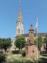
Valdoie, church (église Saint-Joseph) with war monument
See also
| Wikimedia Commons has media related to Valdoie. |
References
This article is issued from
Wikipedia.
The text is licensed under Creative Commons - Attribution - Sharealike.
Additional terms may apply for the media files.