Villaggio Duca degli Abruzzi
Villaggio Duca degli Abruzzi (often called "Villabruzzi" in Italian) was a village that was founded as an agricultural settlement in Italian Somalia[1].
Data
The famous Duca degli Abruzzi, a senior member of the Italian Royal Family, created the village in 1920 and raised funds for a number of development projects in this agricultural place, including roads, dams, schools, hospitals, a church and a mosque. He died in the village on 18 March 1933.
The Mogadishu-Villabruzzi Railway was initially built for the surrounding area of Mogadishu (Mogadiscio in Italian), after World War I in 1914. In the 1924, it was extended to Afgooye. In 1927, it was extended again by the Duca degli Abruzzi to the Shebelle River colonial village he was then developing.[2] The line, 114 km long, reached Villabruzzi in 1928. The original proposal was for the railway to go on from Villabruzzi to the Somali border with Ethiopia and into the Ogaden, but the Second Italo-Abyssinian War in 1936 stopped further construction.
From 1911 in the Shebeli river area the Italian government started to take the local farmers and resettle them in specific new villages in an attempt to improve the economy of Italian Somalia. The area around the "Villaggio Duca degli Abruzzi" was the most agriculturally developed of Somalia before World War II and had some food industries.[3]
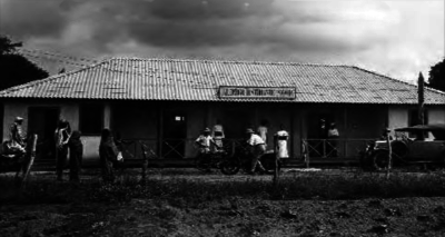
In the Villaggio Duca degli Abruzzi the Italian colonists were experimenting with new cultivation techniques. In 1926, the colony comprised 16 villages, with some 3,000 Somali and 200 Italian inhabitants. It was commonly known as Villabruzzi.
In 1940, Villabruzzi had a population of 12,000, of whom nearly 3,000 were Italian Somalis, and enjoyed a notable level of development as a small manufacturing area.
Villabruzzi grew mainly after the creation of the SAIS (a huge farm production company) and the construction of the railway connecting it to Italian Mogadishu[4]. the 114 km of the railways allowed easy exportation to the Port of Mogadiscio of the huge farms production.
The company SAIS ("Societa Agricola Italo-Somala") was founded in Milan by the Duca d'Abruzzi in November 1920 with a capital of 24 million pounds of the time. A great facility, the only one in East Africa, equipped with modern machinery and able to work about 3,000 tons of sugarcane per day. Next to the sugar mill, he created in Villabruzzi a distillery and a chemical laboratory for analysis of the sugarcane and for the control of the products during the processing phase. The main machines were powered by the combustion of natural gas obtained from the fermentation of waste from sugar cane and cereals processed. Fernando Termentini in "Somalia, una nazione che non esiste"
In 1940, the "Villaggio Duca degli Abruzzi" (actually known as "Jowhar") already had a population of 12,000, of whom nearly 3,000 were Italian Somalis, and enjoyed a notable level of development also as a small manufacturing area.
The Italians, who believed in the economic potential of the region, also built a small Decauville railway that linked Jowhar's area to the Ethiopia border. It is noteworthy to pinpoint that nearly all the development in Italian Somalia was in the triangle "Villabruzzi-Genale-Mogadiscio".
At independence, the vacuum created by the outgoing Italians was not filled by the new Somali élites in charge, as the latter deemed the cattle trade and urban assets more profitable.
WW2 hit hard the city and the agricultural production of the surrounding area. Currently the city has a new name: Jowhar.
Notes
Bibliography
- Hess, Robert. Italian Colonialism in Somalia. University of Chicago P. Chicago, 1966.
- Termentini, Fernando. Somalia, una nazione che non esiste. Pagine di Difesa (Saggio). Maggio 2005.
- Tripodi, Paolo. The Colonial Legacy in Somalia. St. Martin's P Inc. New York, 1999.
- Dell'Osa, Paolo. Il principe esploratore. Mursia, Milano 2010.
See also
Italian Somalia | ||
|---|---|---|
| Main authorities | 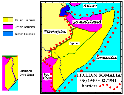 | |
| Governors |
| |
| General History | ||
| Infrastructures | ||
| Related articles |
| |
| Colonial troops | ||