Villa Faraldi
| Villa Faraldi Villa Faródi | |
|---|---|
| Comune | |
| Comune di Villa Faraldi | |
 Villa Faraldi | |
 Villa Faraldi Location of Villa Faraldi in Italy | |
| Coordinates: 43°58′N 8°5′E / 43.967°N 8.083°ECoordinates: 43°58′N 8°5′E / 43.967°N 8.083°E | |
| Country | Italy |
| Region | Liguria |
| Province | Province of Imperia (IM) |
| Area | |
| • Total | 9.6 km2 (3.7 sq mi) |
| Population (Dec. 2004) | |
| • Total | 466 |
| • Density | 49/km2 (130/sq mi) |
| Time zone | UTC+1 (CET) |
| • Summer (DST) | UTC+2 (CEST) |
| Postal code | 18010 |
| Dialing code | 0183 |
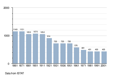
Villa Faraldi (Ligurian: Villa Faródi[1]) is a comune (municipality) in the Province of Imperia in the Italian region Liguria, located about 80 kilometres (50 mi) southwest of Genoa and about 10 kilometres (6 mi) northeast of Imperia. As of 31 December 2004, it had a population of 466 and an area of 9.6 square kilometres (3.7 sq mi).[2]
Villa Faraldi borders the following municipalities: Andora, Diano San Pietro, San Bartolomeo al Mare, and Stellanello.
Demographic evolution
References
- ↑ Frisoni, Gaetano (1910). Dizionario Genovese-Italiano e Italiano-Genovese (in Italian). Genova: Nuova Editrice Genovese.
- ↑ All demographics and other statistics: Italian statistical institute Istat.
Related articles
External links
This article is issued from
Wikipedia.
The text is licensed under Creative Commons - Attribution - Sharealike.
Additional terms may apply for the media files.