Pietrabruna
| Pietrabruna | |
|---|---|
| Comune | |
| Comune di Pietrabruna | |
 Pietrabruna | |
 Pietrabruna Location of Pietrabruna in Italy | |
| Coordinates: 43°53′N 7°54′E / 43.883°N 7.900°ECoordinates: 43°53′N 7°54′E / 43.883°N 7.900°E | |
| Country | Italy |
| Region | Liguria |
| Province | Province of Imperia (IM) |
| Area | |
| • Total | 9.9 km2 (3.8 sq mi) |
| Population (Dec. 2004) | |
| • Total | 568 |
| • Density | 57/km2 (150/sq mi) |
| Time zone | UTC+1 (CET) |
| • Summer (DST) | UTC+2 (CEST) |
| Postal code | 18010 |
| Dialing code | 0 |
Pietrabruna (Ligurian: Priabruna[1] or Prebuna[2]) is a comune (municipality) in the Province of Imperia in the Italian region Liguria, located about 100 kilometres (62 mi) southwest of Genoa and about 11 kilometres (7 mi) west of Imperia. As of 31 December 2004, it had a population of 568 and an area of 9.9 square kilometres (3.8 sq mi).[3]
Pietrabruna borders the following municipalities: Castellaro, Cipressa, Civezza, Dolcedo, Pompeiana, and Taggia.
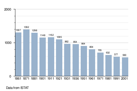
Demographic evolution
References
- ↑ Frisoni, Gaetano (1910–2002). Dizionario Genovese-Italiano e Italiano-Genovese (in Italian). Genova: Nuova Editrice Genovese.
- ↑ Dizionario di toponomastica: Storia e significato dei nomi geografici italiani (in Italian). Milan: Garzanti. 1996. p. 492.
- ↑ All demographics and other statistics: Italian statistical institute Istat.
This article is issued from
Wikipedia.
The text is licensed under Creative Commons - Attribution - Sharealike.
Additional terms may apply for the media files.