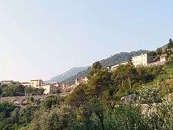
Olivetta San Michele
| Olivetta San Michele Auřivéta San Michèe | ||
|---|---|---|
| Comune | ||
| Comune di Olivetta San Michele | ||
 Olivetta San Michele | ||
| ||
 Olivetta San Michele Location of Olivetta San Michele in Italy | ||
| Coordinates: 43°53′N 7°31′E / 43.883°N 7.517°ECoordinates: 43°53′N 7°31′E / 43.883°N 7.517°E | ||
| Country | Italy | |
| Region | Liguria | |
| Province | Province of Imperia (IM) | |
| Area | ||
| • Total | 13.8 km2 (5.3 sq mi) | |
| Population (Dec. 2004) | ||
| • Total | 245 | |
| • Density | 18/km2 (46/sq mi) | |
| Time zone | UTC+1 (CET) | |
| • Summer (DST) | UTC+2 (CEST) | |
| Postal code | 18030 | |
| Dialing code | 0184 | |

Olivetta San Michele (Royasc: Auřivéta San Michèe,[1] also Ligurian: Aoriveta[2]) is a comune (municipality) in the Province of Imperia in the Italian region Liguria, located about 130 kilometres (81 mi) southwest of Genoa and about 40 kilometres (25 mi) west of Imperia, on the border with France. As of 31 December 2004, it had a population of 245 and an area of 13.8 square kilometres (5.3 sq mi).[3]
Geography
Olivetta San Michele borders the following municipalities: Airole, Breil-sur-Roya (France), Castellar (France), and Ventimiglia.
Demographic evolution

References
- ↑ "Enti in rete L.482/99, Provincia di Imperia". Chambra d'Òc.
Olivetta San Michele - Auřivéta San Michèe
- ↑ Frisoni, Gaetano (1910–2002). Dizionario Genovese-Italiano e Italiano-Genovese (in Italian). Genova: Nuova Editrice Genovese.
- ↑ All demographics and other statistics: Italian statistical institute Istat.
External links
![]()
This article is issued from
Wikipedia.
The text is licensed under Creative Commons - Attribution - Sharealike.
Additional terms may apply for the media files.