Chiusavecchia
| Chiusavecchia Ciusaveia | |
|---|---|
| Comune | |
| Comune di Chiusavecchia | |
 Chiusavecchia | |
 Chiusavecchia Location of Chiusavecchia in Italy | |
| Coordinates: 43°58′N 7°59′E / 43.967°N 7.983°ECoordinates: 43°58′N 7°59′E / 43.967°N 7.983°E | |
| Country | Italy |
| Region | Liguria |
| Province | Province of Imperia (IM) |
| Frazioni | Sarola |
| Area | |
| • Total | 3.3 km2 (1.3 sq mi) |
| Population (Dec. 2004) | |
| • Total | 488 |
| • Density | 150/km2 (380/sq mi) |
| Time zone | UTC+1 (CET) |
| • Summer (DST) | UTC+2 (CEST) |
| Postal code | 18027 |
| Dialing code | 0183 |
| Patron saint | San Biagio |
| Saint day | February 3 |
Chiusavecchia (Ligurian: Ciusaveia) is a comune (municipality) in the Province of Imperia in the Italian region Liguria, located about 90 kilometres (56 mi) southwest of Genoa and about 10 kilometres (6 mi) northwest of Imperia. As of 31 December 2004, it had a population of 488 and an area of 3.3 square kilometres (1.3 sq mi).[1]
The municipality of Chiusavecchia contains the frazione (subdivision) Zebbi.
Chiusavecchia borders the following municipalities: Chiusanico, Lucinasco, and Pontedassio.
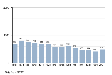
Demographic evolution
References
This article is issued from
Wikipedia.
The text is licensed under Creative Commons - Attribution - Sharealike.
Additional terms may apply for the media files.