Isolabona
| Isolabona L'Isora | |
|---|---|
| Comune | |
| Comune di Isolabona | |
 | |
 Isolabona Location of Isolabona in Italy | |
| Coordinates: 43°53′N 7°38′E / 43.883°N 7.633°ECoordinates: 43°53′N 7°38′E / 43.883°N 7.633°E | |
| Country | Italy |
| Region | Liguria |
| Province | Imperia (IM) |
| Area | |
| • Total | 12.4 km2 (4.8 sq mi) |
| Population (Dec. 2004) | |
| • Total | 715 |
| • Density | 58/km2 (150/sq mi) |
| Time zone | UTC+1 (CET) |
| • Summer (DST) | UTC+2 (CEST) |
| Postal code | 18030 |
| Dialing code | 0184 |
Isolabona (Ligurian: L'Isora[1]) is a comune (municipality) in the Province of Imperia in the Italian region Liguria, located about 120 kilometres (75 mi) southwest of Genoa and about 30 kilometres (19 mi) west of Imperia. As of 2011, it had a population of 716, spread between 333 families throughout an area of 12.4 square kilometres (4.8 sq mi).[2]
Isolabona borders the following municipalities: Apricale, Castelvittorio, Dolceacqua, Pigna and Rocchetta Nervina.
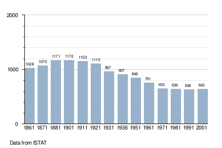
Demographic evolution
References
- ↑ Frisoni, Gaetano (1910–2002). Dizionario Genovese-Italiano e Italiano-Genovese (in Italian). Genova: Nuova Editrice Genovese.
- ↑ All demographics and other statistics: Italian statistical institute Istat.
This article is issued from
Wikipedia.
The text is licensed under Creative Commons - Attribution - Sharealike.
Additional terms may apply for the media files.