Victory, Wisconsin
| Victory, Wisconsin | |
|---|---|
| Unincorporated community | |
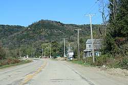 Downtown Victory on WIS35 | |
 Victory, Wisconsin  Victory, Wisconsin | |
| Coordinates: 43°29′08″N 91°12′45″W / 43.48556°N 91.21250°W | |
| Country | United States |
| State | Wisconsin |
| County | Vernon |
| Elevation | 650 ft (200 m) |
| Time zone | UTC-6 (Central (CST)) |
| • Summer (DST) | UTC-5 (CDT) |
| Area code(s) | 608 |
| GNIS feature ID | 1576083[1] |
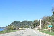
The sign for Victory on WIS35.
Victory is an unincorporated community in the Town of Wheatland in Vernon County, Wisconsin.[1][2] It is located 4.5 miles north of De Soto and 6.2 miles south of Genoa on the Mississippi River along the Great River Road (WIS 35).
History
The Battle of Bad Axe, the final battle of the Black Hawk War of 1832, took place near this community.[3] The community's name commemorates the United States victory.[4]
Notes
- 1 2 U.S. Geological Survey Geographic Names Information System: Victory
- ↑ http://wisconsin.hometownlocator.com/wi/vernon/victory.cfm
- ↑ http://www.mvp.usace.army.mil/Portals/57/docs/Home/History/badaxe.pdf
- ↑ Moyer, Armond; Moyer, Winifred (1958). The origins of unusual place-names. Keystone Pub. Associates. p. 136.
Municipalities and communities of Vernon County, Wisconsin, United States | ||
|---|---|---|
| Cities | 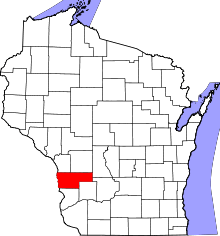 | |
| Villages | ||
| Towns | ||
| Unincorporated communities | ||
| Indian reservation | ||
| Footnotes | ‡This populated place also has portions in an adjacent county or counties | |
Coordinates: 43°29′08″N 91°12′45″W / 43.485497°N 91.212552°W
This article is issued from
Wikipedia.
The text is licensed under Creative Commons - Attribution - Sharealike.
Additional terms may apply for the media files.