Esofea, Wisconsin
| Esofea, Wisconsin | |
|---|---|
| Unincorporated community | |
 Esofea, Wisconsin  Esofea, Wisconsin | |
| Coordinates: 43°37′52″N 90°57′47″W / 43.63111°N 90.96306°W | |
| Country | United States |
| State | Wisconsin |
| County | Vernon |
| Elevation | 978 ft (298 m) |
| Time zone | UTC-6 (Central (CST)) |
| • Summer (DST) | UTC-5 (CDT) |
| Area code(s) | 608 |
| GNIS feature ID | 1564696[1] |
Esofea, Wisconsin is an unincorporated community in the town of Jefferson in Vernon County, Wisconsin, United States located along County Road B.[1][2]
History
In the early 1900s Esofea was a stopping point for travelers on horse going between Viroqua and La Crosse. The community had a creamery, general store, school house, and post office. Most were destroyed in the early 1990s to make way for road construction along County Road B. The church, Bethany Lutheran, and a park, Rentz Memorial Park (commonly called Esofea Park),[3] still exist. Two main roads run through the community, County Road B and Park Road.
A tornado landed near Esofea on August 18, 2005 at the time of The Wisconsin Tornado Outbreak of August 2005.[4]
References
Municipalities and communities of Vernon County, Wisconsin, United States | ||
|---|---|---|
| Cities | 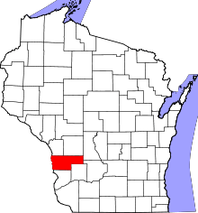 | |
| Villages | ||
| Towns | ||
| Unincorporated communities | ||
| Indian reservation | ||
| Footnotes | ‡This populated place also has portions in an adjacent county or counties | |
Coordinates: 43°37′52″N 90°57′47″W / 43.63111°N 90.96306°W