Veun Sai District
| Veun Sai វើនសៃ | |
|---|---|
| District | |
 location in Ratanakiri Province | |
| Country |
|
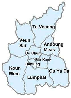
| Province | Ratanakiri Province |
| Population (1998) | |
| • Total | 12,389 |
| Geocode=1409 | |
Veun Sai District (Khmer: វើនសៃ) is a district located in Ratanakiri Province, in north-east Cambodia. The town of Veun Sai is located in the district. It is approximately 38 km north by road of Banlung and is located on the Tonlé San River. The headquarters of Virachey National Park are located in the village. The village is populated by Khmers and many ethnic minorities including Kreung, Lao,[1] and Chinese. Across the Tonle San river are a small Lao village and a small Chinese village.
Administration
The district is subdivided into nine communes (khum),[2] which are further subdivided into 34 villages (phum).
| Khum (commune) | Phum (villages) |
|---|---|
| Ban Pong | Ban Pong, Ban Hvang |
| Hat Pak | Hat Pak, Veun Hay, Lam Poar |
| Ka Choun | Ka Choun Leu, Ka Choun Kraom, Vang, Vay, Tiem Leu, Kok Lak |
| Kaoh Pang | Pa Tang, Lam av, Pa Hay |
| Kaoh Peak | Kaoh Peak, Phak Nam, Khun |
| Kok Lak | La Lai, Rak, La Meuy, Trak |
| Pa Kalan | Pa Kalan, Kampong Cham |
| Phnum Kok | Phnum Kok Lav, Phnum Kok Prov, Kalai Ta Vang, Kalai Sapun, Tiem Kraom |
| Veun Sai | Veun Sai, Pak Kae, I Tub, Thmei, Ka Lan, Kang Nak |
See also
- Lygosoma veunsaiensis first discovered at Veun Sai in 2010.
References
- ↑ Thomas Engelbert; Hans Dieter Kubitscheck (30 June 2004). Ethnic minorities and politics in Southeast Asia. Peter Lang. p. 227. ISBN 978-3-631-38990-4.
- ↑ "National Institute of Statistics". Archived from the original on 2004-12-23. Retrieved 2004-12-23.
External links
Capital city: Banlung | |||||||||||||||||||
| Landmarks | 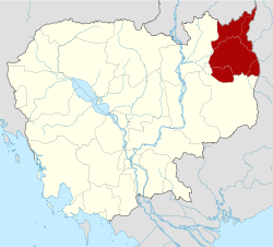 | ||||||||||||||||||
| Administrative divisions |
| ||||||||||||||||||
Coordinates: 14°08′50″N 106°49′02″E / 14.1472°N 106.8173°E
This article is issued from
Wikipedia.
The text is licensed under Creative Commons - Attribution - Sharealike.
Additional terms may apply for the media files.