Samlout District
| Samlout ស្រុកសំឡូត | |
|---|---|
| District (srok) | |
| Country |
|
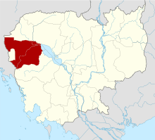
| Province | Battambang |
| Communes | 7 |
| Villages | 49 |
| Time zone | +7 |
| Geocode | 0209 |
Samlout District (Khmer: ស្រុកសំឡូត) is a district (srok) of Battambang Province, in north-western Cambodia.
Administration
The district is subdivided into 7 communes (khum) and 49 villages (phum).[1] Due to conflict, census enumeration could not be conducted in Samlout district during the 1998 Census.[2]
Communes and villages
| Khum (Communes) | Phum (Villages) |
|---|---|
| Ta Taok | OU Nonoung, Ou Kroach, Ou Traeng, Peam Ta, Peam, Ou Ta Teak, Ta Tok, Veal Rolueum, Phnum Rai |
| Kampong Lpou | Svay Chrum, Ou Daem Chek, Kampong Lpov, Ou Choam Kandal, Ou Choam Kraom, Ou Choam Leu, Kandal, Stueng Touch, Prey Thum |
| Ou Samrel | Ou Rumchek Kraom, Ou Rumchek Leu, Chamlang Romeang Kraom, Chamlang Romeang leu, Ou Samrael Kraom, Ou Samrael Leu |
| Sung | Chamkar Chek, Kandal, Kanh Chaang, Sre Reach, Shoung Muoy, Shuong Pir |
| Samlout | Chhar RoKar, Kantuot, Ou Chrab, Samlout, Srae Andoung Muy, Bueng Run |
| Mean Cheay | Sre Sdao, Kampong Touk, Sre Chi Pao, Kam Chat, Ambib, Ta Non |
| Ta Sanh | Anlong Pouk, Doun Troek, Ou Sngout, Ou Tontim, Prey Rumchek, Ta Sanh Khang Chhueng, Ta Sanh Khang Tboang |
References
- ↑ "Battambang Administration". Royal Government of Cambodia. Archived from the original on 2008-12-24. Retrieved 2009-01-22.
- ↑ General Population Census of Cambodia, 1998: Village Gazetteer. National Institute of Statistics. February 2000. pp. xv.
This article is issued from
Wikipedia.
The text is licensed under Creative Commons - Attribution - Sharealike.
Additional terms may apply for the media files.