Siem Reap District
| Siem Reap ស្រុកសៀមរាប | |
|---|---|
| District (srok) | |
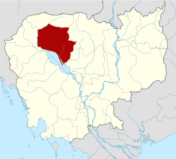
 Siem Reap Location in Cambodia | |
| Coordinates: 13°20′N 103°50′E / 13.333°N 103.833°E | |
| Country |
|
| Province | Siem Reap |
| Time zone | +7 |
| Geocode | 1710 |
Siem Reap District is an administrative district located in Siem Reap Province, in north-west Cambodia. According to the 1998 census of Cambodia, it had a population of 119,528.[1] It surrounds the provincial city of Siem Reap.
| Code Commune | Name Commune Language Khmer | Name Commune Language English |
|---|---|---|
| ១៧១០០១ | ស្លក្រាម | Sla Kram |
| ១៧១០០២ | ស្វាយដង្គំ | Svay Dangkum |
| ១៧១០០៣ | គោកចក | Kouk Chak |
| ១៧១០០៤ | សាលាកំរើក | Sala Kamraeuk |
| ១៧១០០៥ | នគរធំ | Nokor Thum |
| ១៧១០០៦ | ជ្រាវ | Chreav |
| ១៧១០០៧ | ចុងឃ្នៀស | Chong Khnies |
| ១៧១០០៨ | សំបួរ | Sambuor |
| ១៧១០០៩ | សៀមរាប | Siem Reab |
| ១៧១០១០ | ស្រង៉ែ | Srangae |
References
- ↑ "General Population Census of Cambodia 1998, Final Census Results" (PDF). National Institute of Statistics, Ministry of Planning, Cambodia. August 2002. Retrieved 2010-11-25. See page 227.
External links
Coordinates: 13°20′N 103°50′E / 13.333°N 103.833°E
This article is issued from
Wikipedia.
The text is licensed under Creative Commons - Attribution - Sharealike.
Additional terms may apply for the media files.