Thpong District
| Thpong ស្រុកថ្ពង | |
|---|---|
| District (srok) | |
 Thpong Location in Cambodia | |
| Coordinates: 11°44′N 104°26′E / 11.733°N 104.433°E | |
| Country |
|
| Province | Kampong Speu |
| Communes | 7 |
| Villages | 72 |
| Population (1998)[1] | |
| • Total | 43,516 |
| Time zone | +7 |
| Geocode | 0508 |
Thpong District (Khmer: ស្រុកថ្ពង) is a district (srok) located in Kampong Speu Province in central Cambodia.
Geography
The district is located in central Cambodia. Neighbouring districts are (from the east clockwise) Odongk, Samraong Tong and Aoral. To the north are the districts Tuek Phos and Sameakki Mean Chey of Kampong Chhnang Province.
Administration
Thpong District is subdivided into 7 communes (khum)[2]
| Geocode | Name | |
|---|---|---|
| 050801 | Amleang | អមលាំង |
| 050802 | Monourom | មនោរម្យ |
| 050804 | Prambei Mom | ប្រាំបីមុម |
| 050805 | Rung Roeang | រុងរឿង |
| 050806 | Toap Mean | ទ័ពមាន |
| 050807 | Veal Pon | វាលពន់ |
| 050808 | Yea Angk | យាអង្គ |
References
- ↑ General Population Census of Cambodia, 1998: Village Gazetteer. National Institute of Statistics. February 2000. pp. 136–137.
- ↑ National Institute of Statistics
| Capital city | 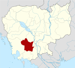 | |
|---|---|---|
| Districts | ||
Coordinates: 11°44′N 104°26′E / 11.733°N 104.433°E
This article is issued from
Wikipedia.
The text is licensed under Creative Commons - Attribution - Sharealike.
Additional terms may apply for the media files.