Angkor Chum District
| Angkor Chum ស្រុកអង្គរជុំ | |
|---|---|
| District (srok) | |
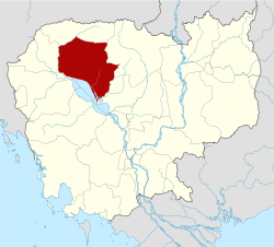
 Angkor Chum Location in Cambodia | |
| Coordinates: 14°10′N 104°20′E / 14.167°N 104.333°E | |
| Country |
|
| Province | Siem Reap |
| Time zone | +7 |
| Geocode | 1701 |
Angkor Chum District (Khmer: ស្រុកអង្គរជុំ, literally "City of the Periphery" ) is a district of Siem Reap Province, in north western Cambodia. According to the 1998 census of Cambodia, it had a population of 48,476.[1]
Administrative divisions
Angkor Chum District a district in Siem Reap. The district has 7 communes and ? villages.
| Code Commune | Commune | Language Khmer | Village |
|---|---|---|---|
| ១៧០១០១ | Char Chhuk Commune | ឃុំចារឈូក | ប្រាសាទ, យាង, អានូក, ព្រៃលៃ្វ, ព្រៃចេង, ក្បាលចាម, គោកល្វា, ចាររកា, ថ្នល់, ឈូក, គោកក្បាត់, តាទយ, ព្រៃទទឹង, ដូនស្វា, មាជា, គោកថ្នល់, ខ្លុង, ថ្មី, គោកធ្នង់, កត្រកៀត |
| ១៧០១០២ | Doun Peaeng Commune | ឃុំដូនពេង | រកា, បត់, គោកយាង, បុស្សល្អុង, បេង, ខ្ចាស់, ដូនពេង, រំដួលថ្មី |
| ១៧០១០៣ | Kouk Doung Commune | ឃុំគោកដូង | ទំរាប់, ខ្ចារ, គោកដូងថ្មី, គោកព្នៅ, គោកត្របែក, អន្ទិតសុខ, រកា, គោកក្រោល, កប្តៀក, ចេកក្បូរ, គោកស្នួល, ប្រាសាទត្រាវ, កំប្លើប, ដូនឯម, គោកដូងចាស់ |
| ១៧០១០៤ | Koul Commune | ឃុំគោល | ខ្វាវ, ខាន់សរ, គោល, អំពិលធ្នង់, ដូនមៀវ, តាគួយ, ព្រៃអារ |
| ១៧០១០៥ | Nokor Pheas Commune | ឃុំនគរភាស | រមៀត, ល្បើក, សំបួរ, គោកថ្មី, ទនេ្លសរ, កុក, ពង្រ, នគរភាស១, នគរភាស២, ជំពូង |
| ១៧០១០៦ | Srae Khvav Commune | ឃុំស្រែខ្វាវ | រាជជន្ទល់, រវៀងថ្មី, ស្រែខ្វាវ, គោកក្នាំង, គោកចាស់, ជំនុំរាជ្យ, ស្លាត, ស្រែប្រាំង, រណ្តាស, រលំ, ទឹកថ្លា |
| ១៧០១០៧ | Ta Saom Commune | ឃុំតាសោម | ថ្នល់, ព្នៅ, ម្កាក់, គោកចាន់, ក រលំ, ទំពូង, ប្រាំដំឡឹង, តាលាវ, បាយម៉ាត, ត្រពាំងភ្លោះ, តាសោម, គោកថ្មី, ស្វាយជុំ |
References
- ↑ "General Population Census of Cambodia 1998, Final Census Results" (PDF). National Institute of Statistics, Ministry of Planning, Cambodia. August 2002. Retrieved 2010-11-25. See page 226.
This article is issued from
Wikipedia.
The text is licensed under Creative Commons - Attribution - Sharealike.
Additional terms may apply for the media files.