Uniontown, Arkansas
| Uniontown, Arkansas | |
|---|---|
| Unincorporated community | |
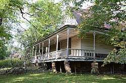 Slack-Comstock-Marshall Farm | |
 Uniontown, Arkansas  Uniontown, Arkansas | |
| Coordinates: 35°35′04″N 94°26′39″W / 35.58444°N 94.44417°WCoordinates: 35°35′04″N 94°26′39″W / 35.58444°N 94.44417°W | |
| Country | United States |
| State | Arkansas |
| County | Crawford |
| Elevation | 866 ft (264 m) |
| Time zone | UTC-6 (Central (CST)) |
| • Summer (DST) | UTC-5 (CDT) |
| ZIP code | 72955 |
| Area code(s) | 479 |
| GNIS feature ID | 78629[1] |
Uniontown is an unincorporated community in Crawford County, Arkansas, United States. Uniontown is located on Arkansas Highway 220 near the Oklahoma border, 4.5 miles (7.2 km) west-northwest of Cedarville. Uniontown has a post office with ZIP code 72955.[2]
History
The first permanent settlement at Uniontown was made in the 1840s by the Howell family.[3] A post office has been in operation at Uniontown since 1881.[4]
Slack-Comstock-Marshall Farm, which is listed on the National Register of Historic Places, is located in the community.[5]
References
- ↑ U.S. Geological Survey Geographic Names Information System: Uniontown, Arkansas
- ↑ ZIP Code Lookup Archived June 15, 2011, at the Wayback Machine.
- ↑ History of Benton, Washington, Carroll, Madison, Crawford, Franklin, and Sebastian Counties, Arkansas. Higginson Book Company. 1889. p. 554.
- ↑ "Post Offices". Jim Forte Postal History. Retrieved 6 February 2018.
- ↑ National Park Service (2009-03-13). "National Register Information System". National Register of Historic Places. National Park Service.
| Wikimedia Commons has media related to Uniontown, Arkansas. |
Municipalities and communities of Crawford County, Arkansas, United States | ||
|---|---|---|
| Cities | 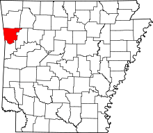 | |
| Towns | ||
| Unincorporated communities | ||
| Ghost towns | ||
This article is issued from
Wikipedia.
The text is licensed under Creative Commons - Attribution - Sharealike.
Additional terms may apply for the media files.