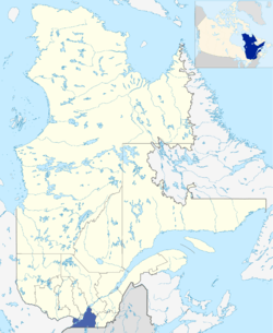
Montérégie
| Montérégie | |
|---|---|
| Administrative region | |
 | |
| Coordinates: 45°23′N 73°06′W / 45.383°N 73.100°WCoordinates: 45°23′N 73°06′W / 45.383°N 73.100°W | |
| Country |
|
| Province |
|
| Regional County Municipalities (RCM) and Equivalent Territories (ET) | |
| Area[1] | |
| • Total | 11,851 km2 (4,576 sq mi) |
| • Land | 11,131.32 km2 (4,297.83 sq mi) |
| Population (2011)[1] | |
| • Total | 1,442,433 |
| • Density | 129.6/km2 (336/sq mi) |
| Demonym(s) | Montérégien(ne) |
| Time zone | UTC-5 (EST) |
| • Summer (DST) | UTC-4 (EDT) |
| Postal code | J |
| Area code | 450, 579 |
| Website | monteregie.gouv.qc.ca |
| [1] | |
Montérégie (French pronunciation: [mɔ̃teʁeʒi]) is an administrative region in the southwest part of the Canadian province of Quebec. It includes the cities of Boucherville, Brossard, Granby, Longueuil, Salaberry-de-Valleyfield, Saint-Jean-sur-Richelieu, Saint-Hyacinthe, Sorel-Tracy, and Vaudreuil-Dorion.
The region has a population of 1,442,433 (2011) and a land area of 11,131.32 square kilometres (4,297.83 sq mi), giving it a population density of 129.6 hab/km² (336/sq mi). It is the second most populous region of Quebec after Montreal. The majority of the population lives near the Saint Lawrence River, on the south shore of Montreal.
Montérégie is known for its vineyards, orchards, panoramas, delicious products, and the Monteregian mountains. The region is both urban (second in terms of population in Quebec) and rural. The regional economy is based on agriculture and the production of goods and services. Tourism also makes up a significant portion of the economy.
History
Montérégie is named for the Monteregian Hills, which are in turn named for Mount Royal (Mont Royal in the original French). Montérégie was populated by the Iroquois when the French began to colonize here in the beginning of the 17th century.
Samuel de Champlain built several forts to protect the colonists against the Iroquois and against the English, who were colonizing New England to the southeast. N.B.: Jacques Cartier was the first European to "discover" Mont Royal, naming it in October 1535.[2]
Some of the battles which decided the destiny of Canada took place in Montérégie. Originally, the administrative territory of the Montérégie parishes were taken from the territory of the canonical Diocese of Saint-Jean-Longueuil.
Subregions
The Montérégie comprises three administrative subregions, each consisting of its own Regional County Municipalities (RCM) or Equivalent Territories. The territorial administration of the region is conducted by three Regional Conferences of Elected Officers (French: Conférences régionales des élus) (CRE) separate and independent in their territory: Longueuil, Montérégie-Est (eastern RCMs) and Vallée-du-Haut-Saint-Laurent (western RCMs). Each sub-region is organized in the same way as other administrative regions of Quebec.
Regional County Municipalities
There are 14 Regional County Municipalities in Montérégie.
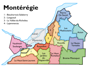
Montérégie Est
There are nine RCMs in Montérégie Est. Its seat is McMasterville, and the president is Arthur Fauteux. Its territory occupies 7,122.92 square kilometres (2,750.17 sq mi) and there are 656,287 inhabitants, with a population density of 92.1/km2 (238.6/sq mi).
| Regional County Municipality (RCM) | Population Canada 2016 Census[3] |
Land Area | Density (pop. per km2) |
Seat of RCM |
|---|---|---|---|---|
| Acton | 15,594 | 579.80 km2 (223.86 sq mi) | 26.9 | Acton Vale |
| Brome-Missisquoi | 58,314 | 1,652.08 km2 (637.87 sq mi) | 35.3 | Cowansville |
| La Haute-Yamaska | 88,306 | 636.81 km2 (245.87 sq mi) | 138.7 | Granby |
| La Vallée-du-Richelieu | 124,420 | 588.60 km2 (227.26 sq mi) | 211.4 | McMasterville |
| Le Haut-Richelieu | 117,443 | 936.02 km2 (361.40 sq mi) | 125.5 | Saint-Jean-sur-Richelieu |
| Les Maskoutains | 87,099 | 1,302.90 km2 (503.05 sq mi) | 66.9 | Saint-Hyacinthe |
| Marguerite-D'Youville (formerly Lajammerais until January 2011) |
77,550 | 346.04 km2 (133.61 sq mi) | 224.1 | Verchères |
| Pierre-De Saurel (formerly La Bas-Richelieu until January 2009) |
51,025 | 597.55 km2 (230.72 sq mi) | 85.4 | Sorel-Tracy |
| Rouville | 36,536 | 483.12 km2 (186.53 sq mi) | 75.6 | Marieville |
Vallée-du-Haut-Saint-Laurent
There are five RCMs in Vallée-du-Haut-Saint-Laurent. Its seat is Salaberry-de-Valleyfield, and its president is Yves Daoust. Its territory occupies 3,727.22 square kilometres (1,439.09 sq mi) and there are 435,436 inhabitants, with a population density of 116.8/km2 (302.6/sq mi).
| Regional County Municipality (RCM) | Population Canada 2016 Census[3] |
Land Area | Density (pop. per km2) |
Seat of RCM |
|---|---|---|---|---|
| Beauharnois-Salaberry | 64,320 | 471.26 km2 (181.95 sq mi) | 136.5 | Beauharnois |
| Le Haut-Saint-Laurent | 22,454 | 1,173.51 km2 (453.09 sq mi) | 19.1 | Huntingdon |
| Les Jardins-de-Napierville | 27,870 | 803.07 km2 (310.07 sq mi) | 34.7 | Napierville |
| Roussillon | 171,443 | 423.82 km2 (163.64 sq mi) | 404.5 | Saint-Constant |
| Vaudreuil-Soulanges | 149,349 | 855.56 km2 (330.33 sq mi) | 174.6 | Vaudreuil-Dorion |
Equivalent territory
| Equivalent Territory (ET) | Population Canada 2016 Census[3] |
Land Area | Density (pop. per km2) |
Seat of ET |
|---|---|---|---|---|
| Agglomeration of Longueuil | 415,347 | 282.21 km2 (108.96 sq mi) | 1,471.80 | Longueuil |
Native Reserves
The population of both of these reserves are majority-Mohawk, one of the historic Five Nations of the Haudenosaunee, or Iroquois League. Kahnawake was established south of Montreal in 1719 as a mission village. Akwesasne was established upriver by Mohawk leaders and their families in the mid-18th century, accompanied by French Jesuit missionaries. Akwesasne spans the boundaries of Canada and the United States, extending across the St. Lawrence River into New York State, where it is referred to as the St. Regis Reservation.
Major communities
References
- 1 2 3 "Montérégie, Quebec (Code 2435) and Quebec (Code 24) (table). Census Profile". Canada 2011 Census. Ottawa, Ontario: Statistics Canada. 2012-05-29. Retrieved 30 June 2012.
- ↑ The Voyages of Jacques Cartier [Original Diary]. By H.P. Biggar. F.A. Acland Printer to the King's Most Excellent Majesty: Ottawa 1924. p.155
- 1 2 3 "Population and dwelling counts, for Canada, provinces and territories, and census divisions, 2016 and 2011 censuses". Canada 2016 Census. Statistics Canada. 2018-02-08. Retrieved 5 March 2018.
External links
| Wikimedia Commons has media related to Montérégie. |
| Wikivoyage has a travel guide for Montérégie. |
- Portail régional de la Montérégie Official website (in French)
- Site officiel de la CRÉ de Longueuil (in French)
- Site officiel de la CRÉ de la Montérégie-Est (in French)
- Site officiel de la CRÉ de la Vallée-du-Haut-Saint-Laurent (in French)
- Agence de la santé et des services sociaux de la Montérégie (in French)
| Subdivisions | |
|---|---|
| Communities | |
| Major cities | |
| Regions | |
| Authority control |
|---|