Valdelinares
| Valdelinares | |
|---|---|
| municipality | |
 Valdelinares | |
 | |
| Coordinates: 40°24′N 0°36′W / 40.400°N 0.600°WCoordinates: 40°24′N 0°36′W / 40.400°N 0.600°W | |
| Country | Spain |
| Autonomous community | Aragon |
| Province | Teruel |
| Municipality | Valdelinares |
| Area | |
| • Total | 55.09 km2 (21.27 sq mi) |
| Elevation | 1,690 m (5,540 ft) |
| Population (2015) | |
| • Total | 85 |
| • Density | 1.5/km2 (4.0/sq mi) |
| Time zone | UTC+1 (CET) |
| • Summer (DST) | UTC+2 (CEST) |
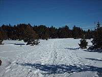
Black pine forest, the most widespread trees in the area
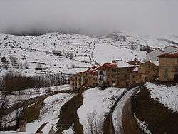
Valdelinares is a municipality and ski resort located in the Sierra de Gúdar range of the Sistema Ibérico, in the province of Teruel, Aragon, Spain. According to the 2004 census (INE), the municipality had a population of 141 inhabitants.
The elevation of the village is 1,690 metres (5,540 ft) above sea level, making this settlement the highest one in Peninsular Spain among those which are the seat of a municipality.[1]
Valdelinares has a mostly dry, high mountain climate with lots of snow in winter. Winter sports can be practised in the nearby resort of Aramón, 7 kilometres (4 mi) away.[2] In the summer months the town is popular for the practice of hiking and mountaineering.
See also
References
- ↑ "Sierra de Gudar Route". Archived from the original on 2012-03-19. Retrieved 2012-10-22.
- ↑ Aramón Javalambre
External links
| Wikimedia Commons has media related to Valdelinares. |
| ||
This article is issued from
Wikipedia.
The text is licensed under Creative Commons - Attribution - Sharealike.
Additional terms may apply for the media files.