La Portellada
| La Portellada | |
|---|---|
| municipality | |
 | |
 | |
| Coordinates: 40°53′N 0°4′E / 40.883°N 0.067°ECoordinates: 40°53′N 0°4′E / 40.883°N 0.067°E | |
| Country | Spain |
| Autonomous community | Aragon |
| Province | Teruel |
| Area | |
| • Total | 21.37 km2 (8.25 sq mi) |
| Elevation | 569 m (1,867 ft) |
| Population (2004) | |
| • Total | 277 |
| • Density | 13.2/km2 (34/sq mi) |
| Time zone | UTC+1 (CET) |
| • Summer (DST) | UTC+2 (CEST) |
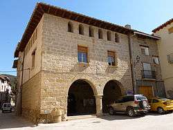
La Portellada (Spanish: [la poɾteˈʎaða]; Catalan: [lə puɾtəˈʎaðə]) is a municipality in the Matarraña/Matarranya comarca, province of Teruel, Aragon, Spain. According to the 2004 census (INE), the municipality has a population of 277 inhabitants.
Geography
Bordering localities
Economy
- Agriculture
- Olive trees, olive oil is a major source of income for this town, the oil belongs to the Denomination of Origin Aragon.
- Almonds are another source of income.
- Cereal
- Livestock
- Swine
- Sheep and goats
- Rabbits
- Fowl
Monuments
Religious sites
- Church of Saints Cosmas and Damian
- Chapel of San Miguel (recreation area)
- Piton de San Pedro Martir
- Virgen del Portillo
Industrial Architecture
- Former "Waterfall mill" (Molí del Salt)
Landforms
- "The Waterfall" (El Salt). A waterfall in the Tastavins river, about 20 feet high.
Other
- "Gavella Pi" (Pine Gavella)
- "Torreta de Ferro" (Iron Tower)
Celebrations
- Major
- Celebrations in Honor of San Cosme and San Damian on September 27, and San Miguel on September 29th
- Minor
- San Anton January 17
- St. Agatha on February 5
- San Pedro Mártir April 29
- First Easter (Easter Monday)
- Second Passover
Typical products
- Olives of the Portellada
- Cured ham (D.O. Jamón de Teruel)
- Casquetes
- Almonds
- Rosca de tallaes (cake with chunks of marinated beef), typical of Easter
This article is issued from
Wikipedia.
The text is licensed under Creative Commons - Attribution - Sharealike.
Additional terms may apply for the media files.