Rubielos de la Cérida
| Rubielos de la Cérida | |
|---|---|
 | |
| Coordinates: 40°46′N 1°12′W / 40.767°N 1.200°WCoordinates: 40°46′N 1°12′W / 40.767°N 1.200°W | |
| Country | Spain |
| Autonomous community | Aragon |
| Province | Teruel |
| Comarca | Jiloca |
| Area | |
| • Total | 66.90 km2 (25.83 sq mi) |
| Elevation | 1,240 m (4,070 ft) |
| Population (2016) | |
| • Total | 39 |
| • Density | 0.58/km2 (1.5/sq mi) |
| Time zone | UTC+1 (CET) |
| • Summer (DST) | UTC+2 (CEST) |
Rubielos de la Cérida is a municipality located in the province of Teruel, Aragon, Spain. According to the 2010 census the municipality had a population of 45 inhabitants.[1] Its postal code is 44166
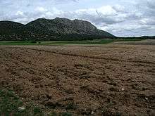
"Pico Palomera", part of the central-uplift chain in the Rubielos de la Cérida impact structure in Sierra Palomera, Sistema Ibérico
See also
References
External links
| Wikimedia Commons has media related to Rubielos de la Cérida. |
This article is issued from
Wikipedia.
The text is licensed under Creative Commons - Attribution - Sharealike.
Additional terms may apply for the media files.