University City, Philadelphia
| University City | |
|---|---|
| Neighborhood of Philadelphia | |
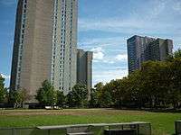
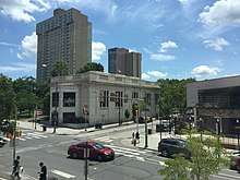     From top left: (1) University City at 40th and Walnut at the northwest corner of the University of Pennsylvania campus. (2) View of University City from the 34th Street bridge (3) At 40th and Chestnut Street (4) Cira Centre (5) Walnut Street Bridge | |
 University City | |
| Coordinates: 39°57′13″N 75°11′55″W / 39.95361°N 75.19861°WCoordinates: 39°57′13″N 75°11′55″W / 39.95361°N 75.19861°W | |
| Country | United States |
| State | Pennsylvania |
| County | Philadelphia County |
| City | Philadelphia |
| Population (2014) | |
| • Total | 50,967[1] |
| ZIP Code | 19104, 19139, and 19143 |
| Area code(s) | Area code 215 |
University City is a contested name for the easternmost region of West Philadelphia and signifies a neighborhood of Philadelphia encompassing several universities. It is the easternmost part of West Philadelphia, situated directly across the Schuylkill River from Center City.
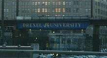
The University of Pennsylvania was instrumental in coining the name "University City" as part of a 1950s urban-renewal and gentrification effort.[2][3] Today, Drexel University and the University of the Sciences also call University City home.
The eastern side of University City is home to the Penn and Drexel campuses, several medical institutions, independent centers of scientific research, 30th Street Station, Cira Centre, and Cira Centre South. The western side contains Victorian and early 20th-century housing stock and is primarily residential.
Demographics
The University City neighborhood consists of 25,183 males and 25,783 females. The area population has grown 2.6% from 2000 to 2014 and 0.7% from 2010 to 2014. There are 32,935 white collar workers and 11,555 blue collar workers.[1]
The area is ethnically and economically diverse, although the compositions of its 12 census tracts vary widely; for example, the population in the mid-2000s of the easternmost tract was about half white and one-third Asian, while that of the northwesternmost tract was almost entirely black.[4]
History
Before the European colonization of the Americas, this area, along with much of the Atlantic's coast from western Connecticut to Delaware, was part of the home of the Lenape people, known as Lenapehoking. University City, like Philadelphia, thus signify what colonizers and their descendants have renamed the area.
In 1677, William Warner purchased 1,500 acres (6.1 km2) from the local Indian tribe and named it Blockley after his native parish in England.[5] Blockley Township had a poor reputation in the 19th century. "It was an ideal hideout for shadowy characters and evil-doers who crossed the river in skiffs after a thieving or smuggling job south of the city. As late as 1850 it was considered hazardous to be abroad alone in this area."[6] The Blockley Almshouse, later known as Philadelphia General Hospital, was there. Though Blockley was founded five years before Philadelphia, people soon referred to it as "West Philadelphia".[7] Later, parts of Blockley were carved out to form the District of West Philadelphia.
In 1735, Andrew Hamilton, a "Philadelphia Lawyer", purchased 300 acres (1.2 km2) in Blockley Township. The area came to be known as Hamilton Village[8] and The Woodlands, a sprawling botanical garden and mansion, was built there. The gardens is now the Woodlands Cemetery, while much of the rest of Hamilton Village is covered by the 40th Street retail corridor.
A small section on the northern side of this area was once known as Greenville.[9] Situated near Lancaster Ave., Powelton Ave., and Market St., Greenville served as a waypoint for travelers and cattle drivers, and many taverns and inns were established. Later, the area expanded in all directions with many German immigrants and offered much more than simple taverns. By the mid-20th century, the Greenville area had changed again, to a neighborhood that was colloquially referred to as the Black Bottom, signifying the neighborhood's racial and economic status. Much of this neighborhood was destroyed as part of a gentrification plan in the 1960s.[10]
The arrival of electrified streetcars in the 1890s kick-started development to the west of 43rd Street, and bridges and a tunnel in the first decade of the 20th century allowed people to easily commute into Center City.[11] This led to rapid development within the borders of University City and far beyond. It was around this time that the "local" neighborhood names like Spruce Hill and Cedar Park[12] were established.
In the mid-1950s, two realtors and Penn graduates coined the name "University City" in an attempt to attract Penn faculty back to the neighborhoods near Penn.[3] The boundaries were defined as extending from the "Schuylkill River to 52nd Street, and from Haverford Avenue to the Media-line railroad tracks south of Kingsessing Avenue — though over the years many have viewed it as a smaller domain". This has led to some community tension; some saw it as an attempt to secede from West Philadelphia.[3]
Boundaries
University City's boundaries, as defined by the non-profit University City District organization and the City of Philadelphia, are the Schuylkill River to the east; Spring Garden Street, Powelton Avenue, and Market Street to the north; 52nd Street to the west; and Woodland Avenue, University Avenue, and Civic Center Boulevard to the south.[13][14][15] Within these boundaries are the local neighborhoods of Cedar Park, Garden Court, Spruce Hill, Squirrel Hill, Powelton Village, Walnut Hill, and Woodland Terrace. The boundaries also encompass several historic districts, including the West Philadelphia Streetcar Suburb Historic District, and the ZIP codes 19104, 19139, and 19143.
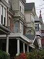 Homes in Cedar Park
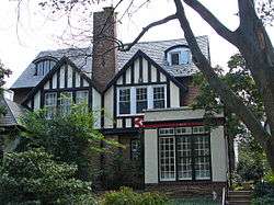 Homes in Garden Court
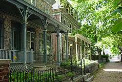 Homes in Powelton Village
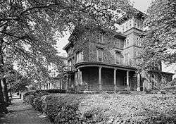 Homes in Woodland Terrace
Town–university relations
University City has a history of strained town and gown relations[16], particularly with the University of Pennsylvania ("Penn" for short), the city's largest private employer and the second-largest private employer in Pennsylvania. During the 1960s, Penn led a series of gentrification and redevelopment programs that have changed the character of the area. Some locals call this "Penntrification" [17] names meant to suggest that the efforts benefit only those with a relationship to Penn. Some, including local anarchists,[18] believe Penn's actions divide the community. Since Penn's massive investment in community relations over the last 25 years it is now considered a model by institutions worldwide, on how a university can better relate to its surrounding residents, businesses, and contribute to quality of life and economic development.[19]
Opened in 2001, the Penn Alexander a neighborhood public elementary school, which Penn helped to build and subsidizes, is open to students inside a wide "catchment" defined by the School District of Philadelphia and Philadelphia City Council.[20] The Penn Mortgage program is a grant made by Penn to any of its staff towards the purchase of a home in West Philadelphia or to be used for the improvement of any staff that currently owns a home in West Philadelphia. The university is also an active participant in branding the area as "University City", with its logo showing up next to the name on signs and bridges (not including street signs directing to University City, which are erected by the city, state, and federal governments).
For decades, 40th Street was generally considered the "invisible campus boundary" between the residential neighborhoods to the west and the Penn campus to the east.[21] In recent years, the "Penn bubble" is said to have expanded further west.[22]
Major redevelopment projects
West Philadelphia Corporation
As part of the Housing Act of 1949, Congress established the "Slum Clearance and Community Development and Redevelopment" program, commissioning federal funds to "assist local communities in eliminating their slums and blighted areas and in providing the maximum opportunity for the redevelopment of project areas by private enterprise."[23] A few years prior, in 1945, the Redevelopment Authority of the City of Philadelphia (RDA) was formed with the power to acquire and redevelop land through condemnation proceedings. This power to take land reached University City when The West Philadelphia Corporation (WPC) was formed in 1959 by a group of local institutions including Penn.[10][24] A 1965 map[25] shows the "units" identified for redevelopment.
Unit 3
Unit 3, the largest of the identified areas, spanned roughly from 34th to 40th streets and North of Chestnut to Lancaster and Powelton streets,[25] covering most of the Black Bottom neighborhood. By 1965, the WPC had developed a plan to demolish homes in Unit 3 and redevelop the land into a center of private scientific research, an expanded hospital, and a large new high school. This particular development was covered in Penn's student newspaper by a five-part series called "The Quiet War" that ran from January 23 to January 27, 1967.[26]
Within four years, the University City Science Center had been established and most of the buildings on Market St. between 34th St. and 40th St. had been demolished.[27]
University City High School was opened in 1972, after years of planning by the WPC and the School District of Philadelphia and conflict with the displaced community.
Unit 4
Much of what is now the center of Penn's campus, including Locust Walk and Superblock, was part of the redevelopment of Unit 4.[25]
Over the course of 1968 to 1970 and with the assistance of the local redevelopment authorities, Penn acquired, cleared and redeveloped the four-block area between 38th, 40th, Spruce, and Walnut streets. The primary features of this area, which became known as "Superblock", are three high-rise apartment-style dormitories.[28] The key purpose of creating these high-rises was to accommodate 3,500 more students at the university. The whole superblock project and especially the high-rise design were widely criticized,[29] but this view is not held by everyone.[30]
Other activity
WPC also guided several other redevelopments that directly benefited Penn and Drexel.[25] Project "A" was the plan to redevelop Units 1a, 1b and 2, the land between 32nd, 34th, Walnut and Chestnut. This resulted in Penn's Women's Dorm (now Hill House) and several Drexel buildings along Chestnut. Additional areas were carved out for Penn's Wharton and Annenberg schools and Physics department. Unit 5 was reserved for Drexel.
Schuylkill riverfront
Along the west bank of the Schuylkill River lie several large parcels of land that have historically seen large-scale non-residential use. As of the 1960s, the most prominent uses of this area were for Philadelphia's main train station, post office, and civic center. Since then, these and other nearby parcels have seen significant redevelopment.
Rail yards
Of particular interest for redevelopment have been the large rail yards near 30th St. Station, now owned by Amtrak. Several plans were made to cover and build over this area. As of 2015, most of these plans, including a baseball stadium[31] and grounds for a World's fair[32] have been scrapped, but more plans are in the works.[33]
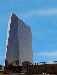
A small part of this area was used to build the Cira Centre, a 29-story, crystal-shaped office tower with distinctive LED lighting visible at night.
Civic Center complex
Beginning in 1991, Penn publicly expressed official interest in acquiring the 19.2 acres (78,000 m2) to the southeast of its campus occupied by the Philadelphia Civic Center complex. After the opening of the Pennsylvania Convention Center in 1992, the Civic Center was mostly unused. In 1998, a City Council resolution was put forth to turn over much of this property to Penn and CHOP.[34] The initial plans were not fully developed, but did not call for the demolition of Convention Hall, the location of several historic events.[35] By 2005, plans had been expanded and the whole site, including Convention Hall, was slated for demolition to make way for a new clinical care facility attached to the hospital. Many local preservationists were opposed to this.[36] Some were mollified by an exhaustive study commissioned by Penn to find alternate uses for the buildings and demolition continued.[37] The last remaining building in the complex, Pennsylvania Hall, was demolished on March 3, 2007.[38] Penn's Perelman Center for Advanced Medicine was officially opened on October 2, 2008.[39]
Postal lands
In 2007, Penn bought 24 acres (97,000 m2) between its campus and the Schuylkill river, an area formerly occupied by the United States Postal Service known as the Postal Lands. (A 1994 map [40] shows the area before the GE building was refurbished into the Left Bank and the Cira Centre was built.[41]) In September 2011 Penn opened Penn Park, a new urban park that stretches from Walnut Street to South Street featuring a fabric of tightly interwoven recreational and athletic components. form and informal playing fields are framed and subdivided by native trees and plantings that extend the beauty of Penn's campus. The park is open to the public and is easily accessed. The other athletic venues include tennis and women's softball. The project includes underground cisterns that collect and repurpose rainwater. The project replaced a 14-acre impervious cement parking lot, which contributed to polluting the nearby river. New buildings replaced a one-time truck annex for the Post Office and now include the headquarters for the FMC Corp., a parking garage with a green roof open to the public, an apartment building, and street-level retail. Center City[42][43] In addition, the former post office building has been turned into office space for the IRS. It is known as Cira Centre South, a two-tower office and residential complex developed by Brandywine Realty Trust, completed in 2016.[44][45][46]
University City District
University City District (UCD) is the name of a private, non-profit organization created by the University of Pennsylvania and other local institutions in 1997 in an effort to provide University City with additional safety, cleanup, and marketing services as well as help in coordinating district initiatives.[47]
UCD demographics report
In 2007, the University City District released a new edition of its University City Report Card, based on 2006 demographic statistics.[48]
The report said the area had 45,787 people living in 16,625 households, 29% of which are classified as "family" households and the rest as "non-family". The average household size was two people, whose median age was 23.8 years. Median household income was $23,749; median "family" household income was $40,042. 8.1% of households had incomes of $100,000 or more and 35.2% had incomes of less than $15,000. The racial makeup of University City was about 42% Black, 35% White, 18% Asian/Pacific Islander, 4% Hispanic, with the remainder not classified.
The report said local businesses employed 63,878, with educational services employing 53.1% of them and health care services 21%. The largest employers were Penn, with 13,239 employees; Penn Health, 11,136; CHoP, 6,855; Drexel-Main, 2,706; AMTRAK, 2,551; and the VA, 2,100.
The median price of homes purchased in 2006 was $312,000, up 22% from 2005. The average monthly rent for a studio apartment was $667; a one-bedroom apartment, $823; and a two-bedroom apartment, $1,174.
Local institutions

Higher education
Sorted by number of students in 2006:[49]
- University of Pennsylvania (23,704): Founded in 1740, moved to current location in 1872.
- Drexel University (Main Campus: 18,466): Founded in 1891 at current location.
- University of the Sciences in Philadelphia (3,008): Founded in 1821, moved to current location in 1928.[50]
- Community College of Philadelphia, West Regional Center (748): Founded in 1965, West campus established in 1985.
- Lincoln University (Urban Center: 596): Main campus in Chester County founded in 1854, Urban Center satellite campus opened in 1976.
- The Restaurant School at Walnut Hill College (535): Founded in 1974, moved to current location in 1992.
- Philadelphia Divinity School (0): Founded in 1858, built campus at 42nd and Spruce in 1921,[51] left neighborhood in 1974.
- Philadelphia College of Osteopathic Medicine (0): Founded in 1899, built campus at 48th and Spruce in 1929,[52] left neighborhood in 1977.[53]
Medical
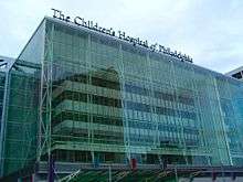
- Children's Hospital of Philadelphia ("CHoP"): Children's hospital
- Hospital of the University of Pennsylvania ("HUP"): General hospital
- Penn Presbyterian Medical Center ("Presby"): General hospital
- VA Medical Center, Philadelphia ("The VA"): Veterans' hospital
- Philadelphia Medical Examiner's Office[54]
- National Board of Medical Examiners: Co-sponsor of the USMLE
Scientific
Not including the scientific departments of the local universities
- Monell Chemical Senses Center: Leader in research on smell and taste.
- University City Science Center: Focuses on commercialization.
- Wistar Institute: Leader in research on the causes and cures of disease.
Cultural
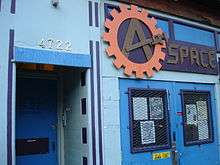
- A-Space, an anarchist community center
- Free Library of Philadelphia, Walnut Street West Branch[55]
- Philadanco, a professional dance company
- University of Pennsylvania institutions include:
- Institute of Contemporary Art, Philadelphia, Penn's modern art museum
- University of Pennsylvania Museum of Archaeology and Anthropology, also called "The Penn Museum"
Charitable
- Neighborhood Bike Works: Donates bicycles and helmets to local kids. Offers training in bicycle repair.
- Philadelphia Elwyn: Care for the mentally disabled.
- Philadelphia Ronald McDonald House: A "home away from home" for families of seriously ill children receiving treatment at nearby hospitals.
Legal
- American Law Institute: Provides Restatements of the Law.
- Dechert: Large Philadelphia law firm
Primary and secondary education
- Public (School District of Philadelphia)
- Henry C. Lea School (K-8): 47th and Locust St.
- Middle Years Alternative & Parkway School (6-12): 49th and Chestnut St.
- Sadie Tanner Mossell Alexander University of Pennsylvania Partnership School (K-8): 42nd and Locust St.
- Samuel Powel School (K-4): 36th and Powelton Ave.
- West Philadelphia High School (9-12): 48th and Chestnut St.
- Private
- Christ Memorial Day School (K-6): 43rd and Chestnut St.
- HMS School for Children with Cerebral Palsy (ages 2–21): 4400 Baltimore Ave.
- Jubilee School (pre-K-6):42nd and Chester Ave.
- Spruce Hill Christian School (K-8): 42nd and Baltimore Ave.
- St. Francis de Sales School (1-8): 912 S. 47th St.
- West Philadelphia Catholic High School (9-12): 45th and Chestnut St.
Transportation
With its compact development and high proportion of students, many people can and do walk and bicycle around, to, and from University City. Additionally, multiple highway, rail, and bus routes pass through University City, including major intercity and regional routes.
Road
The most prominent highway through the region is the Schuylkill Expressway (I-76). I-676 from New Jersey and Center City Philadelphia terminates in University City at I-76. US-30 follows I-76 and I-676. US-13 and PA-3 follow local streets. Of historical note are the Philadelphia and Lancaster Turnpike and Baltimore Pike, now known as Lancaster Ave and Baltimore Ave. Additionally, Philadelphia's historic Market Street runs through the area, where it is known as the Avenue of Technology.
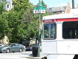
There are several bus lines that serve University City. SEPTA City Transit Division surface routes 21, 30, 40, 42, 78 are active here, as is LUCY, the "Loop through University CitY". Regional bus operators Megabus and BoltBus offer service from near 30th & JFK to NYC.
Rail
The area is served by four distinct types of passenger rail transportation: intercity, regional, metro, and trolley.
Amtrak's Northeast Corridor and Keystone Corridor intercity routes, as well as all of the SEPTA Regional Rail routes and NJT's Atlantic City Line, include a stop at 30th Street Station. SEPTA's Market–Frankford Line (MFL, also known as "the El") and Subway–Surface Trolley Lines stop at the adjacent 30th Street subway station.
There are also several other SEPTA stations in University City, including two more Regional Rail stations: University City and 49th St; three more MFL stations: 34th St., 40th St. and 46th St.; three more underground trolley stations: 33rd St., 36th St., 37th St.; and two trolley portals: 36th St. and 40th St.. West of the portals, the trolleys run on the streets.
An elevated freight line also runs above 31st Street, with connections to several other lines at the Zoo and Arsenal Interlockings, to the north and south, respectively.
Government representation
| Legislative body | District | Representative | Serving since |
|---|---|---|---|
| Philadelphia City Council | 3rd | Jannie Blackwell | 1991 |
| Pennsylvania State Senate | 8th | Anthony H. Williams | 1998 |
| Pennsylvania House of Representatives | 188th | James R. Roebuck, Jr. | 1985 |
| United States House of Representatives | PA-2 | Dwight Evans | 2016 |
| United States Senate | PA | Bob Casey, Jr. | 2007 |
| Pat Toomey | 2011 |
| Executive position | Incumbent | Serving since |
|---|---|---|
| Mayor of Philadelphia | Jim Kenney | 2016 |
| Governor of Pennsylvania | Tom Wolf | 2015 |
| President of the United States | Donald J. Trump | 2017 |
See also
- Templetown, Philadelphia – North Philadelphia neighborhood surrounding Temple University
- University Park, Pennsylvania – The Penn State University campus in central Pennsylvania
References
- 1 2 "University City Population".
- ↑ "The Corporation". uchs.net. Retrieved April 11, 2015.
- 1 2 3 "The Pennsylvania Gazette: The West Philadelphia Story". upenn.edu. Retrieved April 11, 2015.
- ↑ "Mapping America -- Every City, Every Block". New York Times/ Census. Retrieved August 27, 2012.
- ↑ UCHS: Early history of The Area
- ↑ "Blockley". UCHS.net. Retrieved April 11, 2015.
- ↑ "West Philadelphia". UCHSnet. Retrieved March 13, 2017.
- ↑ "Hamilton Village". UCHS.net. Retrieved April 11, 2015.
- ↑ "Greenville". UCHS.net. Retrieved April 11, 2015.
- 1 2 "The Corporation". UCHS.net. Retrieved April 11, 2015.
- ↑ "Studio 34's Eponymous Trolley, or, A Short History of Route 34". Studio 34: Yoga Healing Arts. 2008. Retrieved March 11, 2008.
- ↑ "History". Cedar Park Neighbors. Archived from the original on March 18, 2015. Retrieved April 11, 2015.
- ↑ UCD: Boundary map of University City. Archived July 10, 2007, at the Wayback Machine.
- ↑ UCD: Description of University City's boundaries. Archived February 13, 2008, at the Wayback Machine.
- ↑ "Philadelphia Neighborhoods". Phila.gov. Retrieved April 11, 2015.
- ↑ "The Daily Pennsylvanian :: A fresh coat of paint goes a long way". TheDP.com. Retrieved April 11, 2015.
- ↑ "Oh, Four Oh Four". DailyPennsylvanian.com. Archived from the original on July 16, 2011. Retrieved April 11, 2015.
- ↑ "A-Infos (en) US, Philadelphia, defenestrator* #31 - GENTRIFICATION WATCH - University City: A Real Estate Invention and Herald of Bad Times for Many Residents - By Richard Rodgers". ainfos.ca. Retrieved April 11, 2015.
- ↑ Romano, Lois (January 9, 2006). "Urban Colleges Learn to Be Good Neighbors". Retrieved March 13, 2017 – via washingtonpost.com.
- ↑ "Penn: West Philly: Improving Public Education". Archived from the original on December 7, 2008. Retrieved October 7, 2008.
- ↑ "Gazette - Feature: The Rodin Years". upenn.edu. April 27, 2004. Retrieved April 11, 2015.
- ↑ DP: University City Blues: Meet the often-overlooked West Philadelphians who make life at Penn possible.
- ↑ "A History of the University City Science Center: Part 1, University of Pennsylvania University Archives". UPenn.edu. Retrieved April 11, 2015.
- ↑ "A History of the University City Science Center: Part 2, University of Pennsylvania University Archives". upenn.edu. Retrieved April 11, 2015.
- 1 2 3 4 "University City Map, 1965, University City Science Center". UPenn.edu. Retrieved March 13, 2017.
- ↑ "Search — Daily Pennsylvanian Digital Archives". VeridianSoftware.com. Retrieved March 13, 2017.
- ↑ "A History of the University City Science Center: Part 3, University of Pennsylvania University Archives". UPenn.edu. Retrieved March 13, 2017.
- ↑ "The Pennsylvania Gazette: Sep/Oct Voices from the Undergrad". The Pennsylvania Gazette. Retrieved November 21, 2016.
- ↑ "Getting past a bad precedent". The Daily Pennsylvanian. October 13, 1998. Retrieved November 21, 2016.
- ↑ "Pennsylvania Gazette J/F: Letters". UPenn.edu. Retrieved March 13, 2017.
- ↑ "Archives - Philly.com". Philly.com. Retrieved March 13, 2017.
- ↑ "The City that Might Have Been: Edmund Bacon's Philadelphia". PhillyHistory.org. October 19, 2010. Retrieved March 13, 2017.
- ↑ "Home". PhillyDistrict30.com. Retrieved March 13, 2017.
- ↑ "Oh, Four Oh Four". DailyPennsylvanian.com. Retrieved April 11, 2015.
- ↑ "Oh, Four Oh Four". DailyPennsylvanian.com. Retrieved April 11, 2015.
- ↑ "Ad hoc group is fighting Convention Hall demolition". Philadelphia Business Journal. Retrieved April 11, 2015.
- ↑ "Oh, Four Oh Four". DailyPennsylvanian.com. Retrieved April 11, 2015.
- ↑ Pennsylvania Hall Implosion. YouTube. March 4, 2007. Retrieved April 11, 2015.
- ↑ Perelman Center construction timeline Archived December 7, 2009, at the Wayback Machine.
- ↑ This 1994 map Archived September 3, 2006, at the Wayback Machine.
- ↑ PP: Schuylkill West Bank Map from 1994 redevelopment plan. Archived September 3, 2006, at the Wayback Machine.
- ↑ "Entrepreneur - Start, run and grow your business". Entrepreneur. Retrieved 11 April 2015.
- ↑ "Oh, Four Oh Four". dailypennsylvanian.com. Archived from the original on May 14, 2007. Retrieved April 11, 2015.
- ↑ "Work at Cira Centre South starts". Philadelphia Business Journal. Retrieved 11 April 2015.
- ↑ Penn's official site for Cira Centre South Archived October 29, 2007, at the Wayback Machine.
- ↑ "Oh, Four Oh Four". dailypennsylvanian.com. Retrieved 11 April 2015.
- ↑ UCD: District programs Archived April 18, 2008, at the Wayback Machine.
- ↑ UCD: University City Report Card 2007 Archived February 28, 2008, at the Wayback Machine.
- ↑ UCD: University City Report Card 2007: School populations, p. 11/40 Archived February 28, 2008, at the Wayback Machine.
- ↑ "Kingsessing and Maylandville". UCHS.net. Retrieved April 11, 2015.
- ↑ "03/30/10, At the Former Philadelphia Divinity School Site: Discovering Inspiration from the Past and Creating Spaces to Learn and Grow - Almanac, Vol. 56, No. 27". UPenn.edu. Retrieved March 13, 2017.
- ↑ PCO yearbook from 1942 p. 123
- ↑ "History". PCOM.edu. Retrieved March 13, 2017.
- ↑ "Phila.gov Public Health (Medical Examiner's Office". Retrieved July 24, 2017.
- ↑ Walnut Street West Branch. Free Library of Philadelphia. Retrieved on October 19, 2012.
External links
- WestPhillyNews.org West Philly News - Local news and information. Home of the West Philly Forum, a community bulletin board (CBB).
- WestPhillyLocal.com West Philly Local - A local, independent website that covers West Philadelphia and University City.
- University City Historical District - history of the area now known as West Philadelphia
- Philadelphia Weekly Article Recounting University City's Recent History, Including Changes in the Penn/Community Relationship(PW - Sept. 2006)
- Photo tour of University City
- Photos of the Area
- Neighborhood Profile - from the Penn Library's InfoResources project.
Historical
- University City Historical Society (UCHS) - Local history organization.
- University of Pennsylvania Archives (UPA) - University Archives and Record Center.
- neighborhoodBase from Penn's Cartographic Modeling Laboratory.
- Penn Partners (PP) - The Plan for West Philadelphia, 1994.
Places adjacent to University City, Philadelphia | |
|---|---|