Logan Square, Philadelphia
| Logan Square | |
|---|---|
| Neighborhood of Philadelphia | |
 The Cathedral Basilica of Saints Peter and Paul and Logan Circle sits at the heart of Logan Square. | |
 Logan Square | |
| Coordinates: Coordinates: 39°58′N 75°10′W / 39.96°N 75.17°W | |
| Country |
|
| State | Pennsylvania |
| County | Philadelphia County |
| City | Philadelphia |
| Area code(s) | Area code 215 |
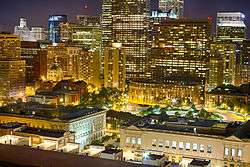
Logan Square is a neighborhood in Philadelphia. Bounded by Market Street on the south, Spring Garden Street on the north, Broad Street on the east, and the Schuylkill River on the west, it occupies the northwest quadrant of Center City. The square for which it is named is one of the five "squares", or parks, central to William Penn's design for Philadelphia. Originally called Northwest Square, it was renamed in honor of James Logan, an eighteenth-century mayor of Philadelphia.
Located here are a number of sites listed on the National Register of Historic Places, including the Arch Street Presbyterian Church, the Bell Telephone Company Building, the Board of Education Building, the Cathedral of Saints Peter and Paul, the Harris Building, the Insurance Company of North America Building, the Larkin–Belber Building, Logan Square, the Francis McIlvain House, St. Clement's Protestant Episcopal Church, the Inquirer Building, and the Wesley Building.[1] Other notable sites are the Academy of Natural Sciences, the Barnes Foundation, the Franklin Institute, the Moore College of Art and Design, the Parkway Central Library, the Pennsylvania Horticultural Society, the Philadelphia Pennsylvania (Mormon) Temple, and the main campus of the Community College of Philadelphia.
Penn Center, Franklintown and much of Philadelphia's central business district are located in Logan Square.
Education
Residents are in the Albert M. Greenfield School catchment area for grades Kindergarten through eight;[2] all persons assigned to Greenfield are zoned to Benjamin Franklin High School.[3] Previously South Philadelphia High School was the neighborhood's zoned high school.[4][5]

See also
References
- ↑ National Park Service (2010-07-09). "National Register Information System". National Register of Historic Places. National Park Service.
- ↑ "k-8 public schools nand catchment map." Center City Schools (Center City District and Central Philadelphia Development Corporation). Retrieved on November 17, 2016.
- ↑ "High School Directory Fall 2017 Admissions" (Archive). School District of Philadelphia. p. 30/70. Retrieved on November 16, 2016.
- ↑ "Albert M. Greenfield School - Where the Graduates Go." Center City Schools.
- ↑ "South Philadelphia High School Geographic Boundaries" (Archive). School District of Philadelphia. Retrieved on November 29, 2015.
External links