Passyunk Square, Philadelphia
| Passyunk Square | |
|---|---|
| Neighborhood of Philadelphia | |
 Geno's Steaks at 9th Street and Passyunk in South Philadelphia | |
 Passyunk Square | |
| Coordinates: Coordinates: 39°55′59″N 75°09′55″W / 39.93303°N 75.16515°W | |
| Country |
|
| State | Pennsylvania |
| County | Philadelphia County |
| City | Philadelphia |
| Area code(s) | Area code 215 |
Passyunk Square is a neighborhood in South Philadelphia bounded by Broad Street to the west, 6th Street to the east, Tasker Street to the south and Washington Avenue to the north. [1] Passyunk Square is bordered by the Bella Vista, Hawthorne, Central South Philadelphia, Wharton and Point Breeze neighborhoods. [2] [3] The neighborhood got its Lenape name from the 1800s Passyunk Township, Pennsylvania which named Passyunk Square Park, located between 12th, 13th, Reed and Wharton Streets. The park was eventually renamed Columbus Square Park, and subsequently the neighborhood became known as Columbus Square. Geoff DiMasi revived the Passyunk Square name when forming the Passyunk Square Civic Association in 2003.[4]
Education
The School District of Philadelphia serves the neighborhood.
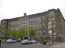
Two K-8 schools, Andrew Jackson School (formerly the Federal Street School) and Eliza Butler Kirkbride School, are listed on the National Register of Historic Places.[5] These schools serve portions of the neighborhood.[6][7] Furness High School serves areas within both the Kirkbride and Jackson zones.[8][9]
Demographics
- White - 68%; Black - 6%; Asian - 19%; Hispanic - 7% [10]
Shopping district
The neighborhood is best known for its shopping and restaurants along the East Passyunk Avenue corridor.
East Passyunk Avenue features a large number of privately owned shops, restaurants, and grocery stores; additionally, it has a number of businesses such as insurance offices, salons, and pharmacies. [11]
See also
External links
References
- ↑ Passyunk Square.org
- ↑ South Philly Review: The Place Where You Live: Point Breeze
- ↑ Philadelphia Neighborhoods
- ↑ "Lower Italian Market Revitalization Project" p. 9 (PDF p/ 14/119). Retrieved on December 30, 2015.
- ↑ National Park Service (2010-07-09). "National Register Information System". National Register of Historic Places. National Park Service.
- ↑ "Andrew Jackson Elementary School Geographic Boundaries" (Archive). School District of Philadelphia. Retrieved on November 28, 2015.
- ↑ "Elizabeth B. Kirkbride Elementary School Geographic Boundaries" (Archive). School District of Philadelphia. Retrieved on November 29, 2015.
- ↑ "A Directory of High Schools for 2009 Admissions" (Archive). School District of Philadelphia. p. 15 (PDF p/ 17/40). Accessed November 6, 2008.
- ↑ "Horace Furness High School Geographic Boundaries" (Archive). School District of Philadelphia. Retrieved on October 4, 2011.
- ↑ The Place Where You Live: Passyunk Square
- ↑ East Passyunk Avenue Business Improvement District business directory