Roxborough-Manayunk
| Roxborough-Manayunk | |
|---|---|
| Neighborhood of Philadelphia | |
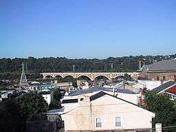 Manayunk skyline in the Roxborough-Manayunk district | |
 Map of Philadelphia County with Northwest highlighted, which contains the Manayunk-Roxborough neighborhood. Click for larger image. | |
| Country |
|
| State |
|
| County |
|
| City |
|
| Population (2010) | |
| • Total | 106,265 |
| ZIP code | 19128 |
The Roxborough-Manyunk section of Philadelphia is an official planning district of the Philadelphia City Planning Commission, consisting of the namesake boroughs of Roxborough and Manayunk.[1] Geographically, the area is northwest of Center City. Today, this area consists of West Oak Lane, East Mount Airy, Andorra, East Falls, Wissahickon, West Mount Airy, Roxborough, and Manayunk.
Demographics
The demographics of Roxborough-Manayunk shows that the area has a population 106,265, with 47,884 males, 58,382 females and a median age of 34.[2]
References
This article is issued from
Wikipedia.
The text is licensed under Creative Commons - Attribution - Sharealike.
Additional terms may apply for the media files.