Uljin County
| Uljin 울진군 | ||
|---|---|---|
| County | ||
| Korean transcription(s) | ||
| • Hangul | 울진군 | |
| • Hanja | 蔚珍郡 | |
| • Revised Romanization | Uljin-gun | |
| • McCune-Reischauer | Ulchin-gun | |
| ||
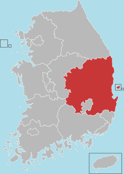
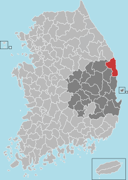 Location in South Korea | ||
| Country |
| |
| Region | Yeongnam, Gwandong (before 1963) | |
| Administrative divisions |
2 eup, 8 myeon Uljin-eup, Pyeonghae-eup, Buk-myeon, Seo-myeon, Geunnam-myeon, Wonnam-myeon, Giseong-myeon, Onjeong-myeon, Jukbyeon-myeon, Hupo-myeon | |
| Government | ||
| • Type | Uljin County | |
| • Mayor | Im Kwang-Won | |
| Area | ||
| • Total | 989.06 km2 (381.88 sq mi) | |
| Population (5/06/2010) | ||
| • Total | 52,385 | |
| • Density | 61.7/km2 (160/sq mi) | |
| • Dialect | Gyeongsang, Gangwon | |
Uljin County (Uljin-gun; Korean: 울진군) is a county in North Gyeongsang Province (Before 1963, Uljin was in Gangwon-do), South Korea.
Culture and sightseeing
Festivals
Uljin's festivals reflect the county's agricultural and maritime industry.
In 2005 and 2009 for three weeks, Uljin hosted the Uljin Organic Food Exhibition (울진세계친환경농업엑스포) in Uljin's Expo Park. The expo features global representatives of the organic food industry, interactive activities, live music, and food. The next expo is slated for July 2013.
Economy
The Uljin Nuclear Power Plant, one of four nuclear power plants in South Korea, is located in Bugu. The plant currently has six reactors and is a top source of jobs for the county and region.[1]
Education
High schools
Middle schools
Elementary schools
- Bugu Elementary School
- Giseong Elementary School
- Hupo Elementary School
- Hupo Dongbu Elementary School
- Jukbyeon Elementary School
- Maewha Elementary School
- Noeum Elementary School
- Onjeong Elementary School
- Pyeonghae Elementary School
- Uljin Elementary School
- Uljin Nambu Elementary School
- Sadong Elementary School
- Samgeun Elementary School
- Wolsong Elementary School
Climate
| Climate data for Uljin (1981–2010, extremes 1971–present) | |||||||||||||
|---|---|---|---|---|---|---|---|---|---|---|---|---|---|
| Month | Jan | Feb | Mar | Apr | May | Jun | Jul | Aug | Sep | Oct | Nov | Dec | Year |
| Record high °C (°F) | 17.4 (63.3) |
22.4 (72.3) |
27.7 (81.9) |
33.7 (92.7) |
33.9 (93) |
36.0 (96.8) |
37.0 (98.6) |
37.8 (100) |
35.4 (95.7) |
29.7 (85.5) |
27.2 (81) |
21.0 (69.8) |
37.8 (100) |
| Average high °C (°F) | 6.2 (43.2) |
7.5 (45.5) |
10.9 (51.6) |
16.8 (62.2) |
20.7 (69.3) |
22.9 (73.2) |
26.3 (79.3) |
27.2 (81) |
23.9 (75) |
20.0 (68) |
14.3 (57.7) |
9.1 (48.4) |
17.2 (63) |
| Daily mean °C (°F) | 1.0 (33.8) |
2.5 (36.5) |
6.4 (43.5) |
12.0 (53.6) |
16.1 (61) |
19.1 (66.4) |
22.8 (73) |
23.8 (74.8) |
19.9 (67.8) |
15.1 (59.2) |
9.1 (48.4) |
3.7 (38.7) |
12.6 (54.7) |
| Average low °C (°F) | −3.2 (26.2) |
−1.8 (28.8) |
1.8 (35.2) |
7.0 (44.6) |
11.6 (52.9) |
15.6 (60.1) |
19.9 (67.8) |
20.9 (69.6) |
16.1 (61) |
10.3 (50.5) |
4.2 (39.6) |
−0.8 (30.6) |
8.5 (47.3) |
| Record low °C (°F) | −14.0 (6.8) |
−14.1 (6.6) |
−10.2 (13.6) |
−3.0 (26.6) |
2.8 (37) |
6.5 (43.7) |
11.9 (53.4) |
11.3 (52.3) |
7.3 (45.1) |
−0.8 (30.6) |
−6.5 (20.3) |
−13.8 (7.2) |
−14.1 (6.6) |
| Average precipitation mm (inches) | 46.7 (1.839) |
41.3 (1.626) |
58.0 (2.283) |
61.0 (2.402) |
70.0 (2.756) |
105.8 (4.165) |
186.8 (7.354) |
208.8 (8.22) |
185.6 (7.307) |
64.2 (2.528) |
57.3 (2.256) |
33.4 (1.315) |
1,119 (44.055) |
| Average precipitation days (≥ 0.1 mm) | 5.4 | 6.3 | 8.3 | 7.3 | 8.0 | 9.6 | 13.8 | 13.2 | 11.1 | 6.5 | 6.2 | 4.2 | 99.9 |
| Average snowy days | 3.3 | 3.3 | 2.7 | 0.1 | 0.0 | 0.0 | 0.0 | 0.0 | 0.0 | 0.0 | 0.3 | 1.6 | 11.3 |
| Average relative humidity (%) | 51.4 | 56.3 | 62.1 | 63.6 | 70.7 | 80.0 | 83.3 | 83.7 | 80.1 | 69.5 | 60.5 | 52.1 | 67.8 |
| Mean monthly sunshine hours | 203.1 | 186.7 | 205.8 | 228.8 | 235.9 | 194.4 | 163.1 | 184.7 | 175.0 | 203.6 | 188.3 | 203.9 | 2,373.2 |
| Percent possible sunshine | 65.9 | 61.1 | 55.5 | 58.1 | 53.8 | 44.2 | 36.5 | 44.0 | 46.9 | 58.4 | 61.4 | 68.0 | 53.3 |
| Source: Korea Meteorological Administration[2][3][4] (percent sunshine and snowy days)[5] | |||||||||||||
Sister cities


References
- ↑ http://eng.knef.or.kr/nuclear/nuclear4.asp
- ↑ "평년값자료(1981–2010) 울진(130)" (in Korean). Korea Meteorological Administration. Retrieved 15 December 2016.
- ↑ "기후자료 극값(최대값) 전체년도 일최고기온 (℃) 최고순위, 울진(130)" (in Korean). Korea Meteorological Administration. Retrieved 15 December 2016.
- ↑ "기후자료 극값(최대값) 전체년도 일최저기온 (℃) 최고순위, 울진(130)" (in Korean). Korea Meteorological Administration. Retrieved 15 December 2016.
- ↑ "Climatological Normals of Korea" (PDF). Korea Meteorological Administration. 2011. p. 499 and 649. Archived from the original (PDF) on 7 December 2016. Retrieved 15 December 2016.
- ↑ "International Exchange". List of Affiliation Partners within Prefectures. Council of Local Authorities for International Relations (CLAIR). Archived from the original on 24 December 2015. Retrieved 21 November 2015.
External links
Andong (capital) | ||||
 | Specific city |
| ||
| Cities | ||||
| Counties | ||||
This article is issued from
Wikipedia.
The text is licensed under Creative Commons - Attribution - Sharealike.
Additional terms may apply for the media files.