Nam-gu, Pohang
| Nam-gu 남구 | |
|---|---|
| Non-autonomous District | |
| Korean transcription(s) | |
| • Hanja | 南區 |
| • Revised Romanization | Nam-gu |
| • McCune-Reischauer | Nam-gu |
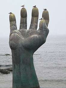 Hand of Coexistence in Homigot | |
 | |
| Country | South Korea |
| Region | Yeongnam |
| Province | North Gyeongsang |
| City | Pohang |
| Administrative divisions | 7 dong, 3 eup, 4 myeon |
| Area | |
| • Total | 393.02 km2 (151.75 sq mi) |
| Population (2012) | |
| • Total | 253,670[1] |
| • Density | 645/km2 (1,670/sq mi) |
| • Dialect | Gyeongsang |
| Website | namgu.ipohang.org |
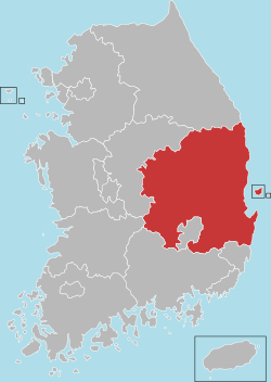
Nam-gu is a non-autonomous district in the City of Pohang in North Gyeongsang Province, South Korea. Its name literally means "South District" as it is one of two districts in the city, the other being Buk-gu or "North District".
Administrative divisions
Nam-gu is divided into 3 towns (eup), 4 townships (myeon), and 7 neighbourhoods (dong).[1]
| Hangul | Hanja | |
|---|---|---|
| Guryongpo-eup | 구룡포읍 | 九龍浦邑 |
| Yeonil-eup | 연일읍 | 延日邑 |
| Ocheon-eup | 오천읍 | 烏川邑 |
| Daesong-myeon | 대송면 | 大松面 |
| Donghae-myeon | 동해면 | 東海面 |
| Janggi-myeon | 장기면 | 長鬐面 |
| Homigot-myeon | 호미곶면 | 虎尾串面 |
| Sangdae-dong | 상대동 | 上大洞 |
| Haedo-dong | 해도동 | 海島洞 |
| Songdo-dong | 송도동 | 松島洞 |
| Cheongnim-dong | 청림동 | 靑林洞 |
| Jecheol-dong | 제철동 | 製鐵洞 |
| Hyogok-dong | 효곡동 | 孝谷洞 |
| Daei-dong | 대이동 | 大梨洞 |
Each town and township are then further divided into numerous villages (ri).
- Guryongpo-eup: Guryongpo-ri (구룡포리/九龍浦里), Samjeong-ri (삼정리/三政里), Seokbyeong-ri (석병리/石屛里), Nultae-ri (눌태리/訥台里), Hudong-ri (후동리/厚洞里), Byeongpo-ri (병포리/柄浦里), Hajeong-ri (하정리/河亭里), Janggil-ri (장길리/長吉里), Gupyeong-ri (구평리/邱坪里), Seongdong-ri (성동리/城洞里)
- Yeonil-eup: Ocheon-ri (오천리/烏川里), Saengji-ri (생지리/生旨里), Goejeong-ri (괴정리/槐亭里), Dongmun-ri (동문리/東門里), Inju-ri (인주리/絪珠里), Taekjeon-ri (택전리/宅前里), Jungdan-ri (중단리/中丹里), Jungmyeong-ri (중명리/中明里), Ubok-ri (우복리/牛伏里), Yugang-ri (유강리/柳江里), Jamyeong-ri (자명리/自明里), Hakjeon-ri (학전리/鶴田里), Daljeon-ri (달전리/達田里)
- Ocheon-eup: Mundeok-ri (문덕리/文德里), Gwangmyeong-ri (광명리/光明里), Segye-ri (세계리/世界里), Yongdeok-ri (용덕리/龍德里), Won-ri (원리/院里), Gujeong-ri (구정리/舊政里), Yongsan-ri (용산리/龍山里), Munchung-ri (문충리/文忠里), Hangsa-ri (항사리/恒沙里), Galpyeong-ri (갈평리/葛坪里), Jinjeon-ri (진전리/陳田里)
- Daesong-myeon: Namseong-ri (남성리/南城里), Jenae-ri (제내리/堤內里), Songdong-ri (송동리/松洞里), Ongmyeong-ri (옥명리/玉明里), Gongsu-ri (공수리/公須里), Jangdong-ri (장동리/長洞里), Honggye-ri (홍계리/洪溪里), Daegak-ri (대각리/大覺里), Sanyeo-ri (산여리/山余里)
See also
References
- 1 2 "포항시 남구청 기본현황 인구/면적 - Nam-gu, Pohang City". Archived from the original on 2011-07-08.
External links
- (in Korean) Official website
Andong (capital) | ||||
 | Specific city |
| ||
| Cities | ||||
| Counties | ||||
Coordinates: 36°01′N 129°22′E / 36.01°N 129.36°E
This article is issued from
Wikipedia.
The text is licensed under Creative Commons - Attribution - Sharealike.
Additional terms may apply for the media files.