Uebigau-Wahrenbrück
| Uebigau-Wahrenbrück | ||
|---|---|---|
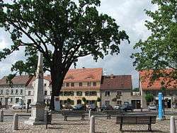 Market square in Uebigau | ||
| ||
 Uebigau-Wahrenbrück Location of Uebigau-Wahrenbrück within Elbe-Elster district 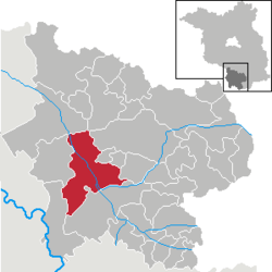 | ||
| Coordinates: 51°33′N 13°21′E / 51.550°N 13.350°ECoordinates: 51°33′N 13°21′E / 51.550°N 13.350°E | ||
| Country | Germany | |
| State | Brandenburg | |
| District | Elbe-Elster | |
| Government | ||
| • Mayor | Andreas Claus | |
| Area | ||
| • Total | 134.91 km2 (52.09 sq mi) | |
| Elevation | 84 m (276 ft) | |
| Population (2017-12-31)[1] | ||
| • Total | 5,321 | |
| • Density | 39/km2 (100/sq mi) | |
| Time zone | CET/CEST (UTC+1/+2) | |
| Postal codes | 04924, 04938 | |
| Dialling codes | 035365 | |
| Vehicle registration | EE | |
| Website | www.uebigau-wahrenbrueck.de | |

Uebigau-Wahrenbrück is a town in the Elbe-Elster district, in southwestern Brandenburg, Germany. It is situated on the river Schwarze Elster, 11 km northwest of Bad Liebenwerda, and 21 km east of Torgau.
Geography
The town is composed by the villages of Bahnsdorf, Beiersdorf, Beutersitz, Bomsdorf, Bönitz, Domsdorf, Drasdo, Kauxdorf, Langennaundorf, Marxdorf, München/Elster, Neudeck, Prestewitz, Rothstein, Saxdorf, Uebigau (municipal seat), Wahrenbrück, Wiederau, Wildgrube, Winkel and Zinsdorf.
Demography
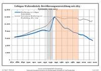 Development of Population since 1875 within the Current Boundaries (Blue Line: Population; Dotted Line: Comparison to Population Development of Brandenburg state; Grey Background: Time of Nazi rule; Red Background: Time of Communist rule)
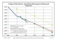 Recent Population Development (Blue Line) and Forecasts
| Uebigau-Wahrenbrück: Population development within the current boundaries (2013)[2] | ||||||||||||||||||||||||||||||||||||||||||||||||||||||||||||||||||||||||||||||||||||||||||||||||||||||||||||||||||||||||||||||||||||||
|---|---|---|---|---|---|---|---|---|---|---|---|---|---|---|---|---|---|---|---|---|---|---|---|---|---|---|---|---|---|---|---|---|---|---|---|---|---|---|---|---|---|---|---|---|---|---|---|---|---|---|---|---|---|---|---|---|---|---|---|---|---|---|---|---|---|---|---|---|---|---|---|---|---|---|---|---|---|---|---|---|---|---|---|---|---|---|---|---|---|---|---|---|---|---|---|---|---|---|---|---|---|---|---|---|---|---|---|---|---|---|---|---|---|---|---|---|---|---|---|---|---|---|---|---|---|---|---|---|---|---|---|---|---|---|
|
|
| ||||||||||||||||||||||||||||||||||||||||||||||||||||||||||||||||||||||||||||||||||||||||||||||||||||||||||||||||||||||||||||||||||||
See also
- Marxdorfer Wolfshund
Sons and daughters of the city
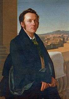
Gustav Seyffarth
- Johann Gottlieb Graun (1702–1771), composer
- Carl Heinrich Graun (1704–1759), composer
- Gustav Seyffarth (1796–1885), Egyptologist
References
- ↑ "Bevölkerung im Land Brandenburg nach amtsfreien Gemeinden, Ämtern und Gemeinden 31. Dezember 2017 (Fortgeschriebene amtliche Einwohnerzahlen auf Grundlage des Zensus 2011)". Amt für Statistik Berlin-Brandenburg (in German). 2018.
- ↑ Detailed data sources are to be found in the Wikimedia Commons.Population Projection Brandenburg at Wikimedia Commons
External links
![]()
| Authority control |
|---|
This article is issued from
Wikipedia.
The text is licensed under Creative Commons - Attribution - Sharealike.
Additional terms may apply for the media files.