U.S. Route 66 in Arizona
| ||||
|---|---|---|---|---|
| Will Rogers Highway | ||||
.svg.png) | ||||
| Route information | ||||
| Maintained by AZDOT (I-40 Bus., SR 66); county and local gov'ts | ||||
| Length | 401 mi (645 km) | |||
| Existed | November 11, 1926–June 26, 1985[1] | |||
| Tourist routes |
| |||
| Major junctions | ||||
| West end |
| |||
| East end |
| |||
| Highway system | ||||
| ||||

U.S. Route 66 (US 66, Route 66) covered 401 miles (645 km) as part of a former United States Numbered Highway in the state of Arizona. The highway ran from west to east, starting in Needles, California, through Kingman and Seligman to the New Mexico state line as part of the historic US 66 from Santa Monica, California, to Chicago, Illinois. The highway was decommissioned in 1985, although portions remain as State Route 66 (SR 66).
History
In 1914 the road was designated National Old Trails Highway; in 1926 it was re-designated US 66 with the birth of the U.S. Numbered Highway System.[2] Throughout the history of US 66 in Arizona, the road largely followed this original path with a notable exception.
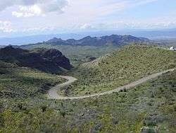
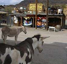
The section between Topock where US 66 entered Arizona from California via the Red Rock Bridge and Kingman originally followed a steep and winding path past Oatman into the Black Mountains and through Sitgreaves Pass. This section was built across this rough terrain instead of following the more level route to the east adopted by the railroad because the road followed the National Old Trails highway which was for gold mining in Oatman and Goldroad, now a ghost town. It was fraught with hairpin turns and was the steepest along the entire route, so much so that some early travelers, too frightened at the prospect of driving such a potentially dangerous road, hired locals to navigate the winding grade. The section remained as Route 66 until 1952 when it was realigned, bypassing Oatman and running along level ground close to the railroad, from Topock to Kingman through Yucca. The original section of US 66 through Oatman is still open to traffic today as the Oatman Highway and has been designated the Route 66 Historic Back Country Byway by the Bureau of Land Management.[3]
In 1979, nearly all of US 66 was approved for decommissioning in Arizona; the highway's western (sic) terminus would now be in Sanders, Arizona, less than 40 miles (60 km) west of the New Mexico state line.[4] On October 13, 1984, Williams, Arizona, was the last point on the former US 66 in the state to be bypassed by an Interstate highway with the completion of Interstate 40 (I-40) there. Later that month, the Arizona Department of Transportation approved a plan to deal with the remains of the highway in Arizona. Parts were either absorbed into I-40, turned over to the state in the form of a newly-minted State Route 66, or turned over to Yavapai County.[5] On June 26, 1985, all of US 66, including the small segment remaining in Arizona, was dropped from the U.S. Highway System.[1]
The ADOT Parkways, Historic and Scenic Roads program recognizes certain sections of former US 66 as Historic Route 66. The longest sections of the designated historic route follow the original US 66 between Topock and Seligman through Oatman and from Flagstaff to Winona. Other smaller sections of Historic Route 66 comprise of former US 66 segments that are currently or were once designated as I-40 Business. This is the case in Ash Fork, Williams, Winslow and Holbrook. Flagstaff is the only city in Arizona where the Historic Route splits into two alignments, the first being the aforementioned route to Winona and the second taking a small section of later US 66 to a junction with I-40 immediately east of Flagstaff. The discontinuous sections of Historic Route 66 are all connected by I-40.[6][7] Historic Route 66 was the only route in the Parkways, Historic and Scenic Roads program to cross the state and the longest state designated historic route in Arizona until the addition of Historic U.S. Route 80 in 2018.[8][6][7] Historic Route 66 is also one of only four state designated Historic Routes, with the others being Historic US 80, the Jerome-Clarkdale-Cottonwood Historic Road (Historic US 89A) and the Apache Trail Historic Road.[8][6]
Route description
California border to Kingman
Route 66 entered Arizona from Needles, California across the Topock Gorge, within the Havasu National Wildlife Refuge,
Between the California state line and Kingman, the original alignment is now known as Oatman Road and passed through the old mining town of Oatman, now a tourist town. A later alignment (via Yucca) is now I-40. The older alignment passes through the Black Mountains complete with numerous hairpin turns. This area is desert.
Kingman to Seligman
SR 66 is the only part of old US 66 in Arizona to have state route markers. It still serves communities that the freeway avoids, including Valentine, Hackberry and Peach Springs; it enters the Hualapai Indian Reservation. Its western terminus is near Kingman at exit 52 on I-40 and its eastern terminus was originally near Seligman at exit 123 on I-40. The state highway designation currently covers just 66 miles (106 km) of a section east of Kingman. The road continues east into Yavapai County as a county-maintained road as the state turned over the easternmost 16.8 miles (27.0 km) of SR 66 (known as Crookton Rd) to Yavapai County in 1990 for maintenance.[9]
Between Kingman and Seligman, I-40's more southerly and more direct path diverges from US 66 by approximately 16 miles (26 km), cutting off businesses on this section from highway traffic on the freeway's completion. Hackberry almost became a ghost town; at one point artist Bob Waldmire (owner of the Hackberry General Store from 1992-1998) was a resident. Members of the Grigg family have lived in Hackberry since the 1890s. Hackberry cemetery has seven generations of Grigg family members buried there.
The Grand Canyon Caverns, just east of Peach Springs, are among the largest of dry caverns in the United States.
Seligman is the birthplace of the first route 66 association, established by local barber Angel Delgadillo in 1987. This group obtained the first "Historic Route 66" designation, which the state initially placed on the segment of US 66 between Kingman and Seligman.
Seligman to New Mexico border

From Seligman to east of Flagstaff, the area is mountainous (not desert) and covered with pine forests. The old section through Flagstaff itself is officially named "Route 66". Shortly before joining I-40 east of Flagstaff, US 66 passes through Winona, a small unincorporated community made famous in the song "(Get Your Kicks on) Route 66".
Several abandoned portions of the former US 66 highway are listed on the National Register of Historic Places. These include Abandoned Route 66, Ash Fork Hill, Abandoned Route 66, Parks (1921) east of Parks, Arizona and Abandoned Route 66, Parks (1921) west of Parks, Arizona.
Williams Historic Business District and Urban Route 66, Williams were added to the National Register of Historic Places in 1984 and 1989, respectively.
The Meteor Crater is south of old US 66 near Winslow. The Homolovi State Park near Winslow preserves over 300 Ancestral Puebloan archaeological sites. At Joseph City is the Jack Rabbit Trading Post, which once posted signs up and down the highway for hundreds of miles, and at Holbrook is the Wigwam Village Motel, a motor court built to resemble a group of teepees. The Petrified Forest National Park is located east of Holbrook. About sixty miles before reaching New Mexico, the highway originally passed through the Painted Desert, though this section is now cut off.
Portions of US 66 were paved over by I-40 construction or converted to frontage roads.


.svg.png)
Major intersections
This list follows the final non-freeway alignment.
| County | Location | mi | km | Destinations | Notes |
|---|---|---|---|---|---|
| Mohave | Topock | 0 | 0.0 | California state line | |
| west end of SR 95 overlap | |||||
| | 0.4 | 0.64 | east end of SR 95 overlap | ||
| McConnico | 48.5 | 78.1 | Oatman Highway - Oatman | ||
| Kingman | 53.5 | 86.1 | west end of US 93 overlap | ||
| 57.4 | 92.4 | east end of US 93 overlap | |||
| Yavapai | Ash Fork | 166.1 | 267.3 | west end of US 89 overlap; now SR 89 | |
| Coconino | Williams | 185.1 | 297.9 | ||
| Flagstaff | 216.2 | 347.9 | Formerly SR 79 | ||
| 216.8 | 348.9 | west end of US 180 overlap | |||
| 220.9 | 355.5 | east end of US 89 overlap | |||
| Winona | Townsend-Winona Road | pre-1947 US 66 west | |||
| Leupp Corner | west end of SR 99 overlap | ||||
| Navajo | Winslow | east end of SR 99 overlap; west end of SR 87 overlap | |||
| | east end of SR 87 overlap | ||||
| Holbrook | east end of US 180 overlap; west end of SR 77 overlap | ||||
| | east end of SR 77 overlap | ||||
| Apache | | Petrified Forest National Park | former SR 63 south | ||
| Chambers | now US 191 north | ||||
| Sanders | west end of US 666 overlap; now US 191 south | ||||
| | New Mexico state line | ||||
1.000 mi = 1.609 km; 1.000 km = 0.621 mi
| |||||
Structures

A Desert Power & Water Co., Electric Power Plant built in 1908 closed in 1938, soon after the Hoover Dam was completed; it now houses a visitor information office and Kingman, Arizona's chamber of commerce.
The Schoolhouse at Truxton Canyon Training School in Valentine operated from 1903-1937 as a mandatory boarding school in which Hualapai were separated from their families and put to work learning various trades.[10] Long a symbol of forced assimilation, the historic building is now the property of the Hualapai Nation.
The Peach Springs Trading Post, constructed in 1928 using local stone and logs, replaced an earlier 1917 trading post at Peach Springs. Its original role was to trade native crafts for foodstuffs, medicine and household goods.[11] The building now houses Hualapai conservation offices.
Lowell Observatory, an astronomical observatory established in Flagstaff in 1894, is one of the oldest observatories in the United States and a designated National Historic Landmark. The observatory is well known for being the location where astronomer Clyde Tombaugh discovered the dwarf planet Pluto on February 18, 1930.[12]
Flagstaff's Santa Fe Railroad Depot, built in 1926, is the busiest of the eight Arizona Amtrak stations and includes a visitor information office. Flagstaff's 43-room Hotel Monte Vista was established in 1927.
Historic districts
- Kingman Commercial Historic District, Kingman[13]
- Seligman Historic District, Seligman[14]
- Railroad Addition Historic District, Flagstaff[15]
- La Posada Historic District in Winslow, which dates from 1930, includes the Winslow Santa Fe station as well as La Posada Hotel and Gardens, a Fred Harvey Company hotel.[16]
Restaurants
Delgadillo's Snow Cap Drive-In in Seligman, built in 1953 with scrap railway lumber by Juan Delgadillo (1916–2004), continues to offer choices such as a "cheeseburger with cheese" and "dead chicken."
Camps, motor courts, and motels
The Oatman Hotel, a historic two-story adobe building which opened in 1902 as the Durlin Hotel and was rebuilt in 1924 during a local gold rush, now houses a bar, restaurant and museum.[17]
The Wigwam Village Motel in Holbrook is distinctive for patented novelty architecture in which every room of the motel is a free-standing concrete wigwam.[18] In Pixar's 2006 animated film Cars, these are depicted as the traffic cones of the Cozy Cone Motel.
The Pueblo Revival style Painted Desert Inn in Navajo, constructed circa-1920 of wood and native stone and purchased by the US National Park Service in 1935, is situated on a mesa overlooking the vast Painted Desert.[19]
Bridges
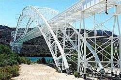
- Old Trails Bridge, Topock[20]
- Walnut Canyon Bridge, Winona[21]
- Querino Canyon Bridge, Houck[22]
- Arizona Road Segments[23]
See also
References
- 1 2 Special Committee on U.S. Route Numbering (June 26, 1985). "Route Numbering Committee Agenda" (Report). Washington, DC: American Association of State Highway and Transportation Officials. p. 5 – via Wikisource.
- ↑ "National Old Trails Highway". Retrieved February 11, 2012.
- ↑ "Route 66 Historic Back Country Byway". Bureau of Land Management. Retrieved January 25, 2018.
- ↑ Special Committee on U.S. Route Numbering (June 25, 1979). "Route Numbering Committee Agenda Showing Action Taken by the Executive Committee" (PDF) (Report). Washington, DC: American Association of State Highway and Transportation Officials. p. 1 – via Wikimedia Commons.
- ↑ Arizona Department of Transportation. "ADOT Right-of-Way Resolution 1984-10-A-065" (PDF). Retrieved May 5, 2008.
- 1 2 3 Arizona Department of Transportation (2014). "Arizona Parkways, Historic and Scenic Roads" (PDF). Phoenix: Arizona Department of Transportation. Retrieved September 11, 2018.
- 1 2 Arizona Scenic Roads Map (PDF) (Map). Phoenix: Arizona Department of Transportation. Retrieved September 12, 2018.
- 1 2 "Historic Arizona U.S. Route 80 Designation". Tucson Historic Preservation Foundation. August 2017. Retrieved August 23, 2018.
- ↑ Arizona Department of Transportation. "ADOT Right-of-Way Resolution 1990-07-A-053". Retrieved May 5, 2008.
- ↑ "Schoolhouse at Truxton Canyon Training School". National Park Service. Retrieved June 12, 2012.
- ↑ "Peach Springs Trading Post". National Park Service. Retrieved June 12, 2012.
- ↑ Howell, Elizabeth (April 26, 2013). "Lowell Observatory: Where Pluto Was Discovered". Space.com. Retrieved April 1, 2015.
- ↑ "Kingman Commercial Historic District". National Park Service. Retrieved June 12, 2012.
- ↑ "Seligman Historic District". National Park Service. Retrieved June 12, 2012.
- ↑ "Railroad Addition Historic District and Boundary Increase". National Park Service. Retrieved June 12, 2012.
- ↑ "La Posada Historic District". National Park Service. Retrieved June 12, 2012.
- ↑ "Durlin Hotel". National Park Service. Retrieved June 12, 2012.
- ↑ "Wigwam Village Motel 6". National Park Service. Retrieved June 12, 2012.
- ↑ "Painted Desert Inn". National Park Service. Retrieved June 12, 2012.
- ↑ "Old Trails Bridge". National Park Service. Retrieved June 12, 2012.
- ↑ "Walnut Canyon Bridge". National Park Service. Retrieved June 12, 2012.
- ↑ "Querino Canyon Bridge". National Park Service. Retrieved June 12, 2012.
- ↑ "Arizona Road Segments". National Park Service. October 13, 1984. Retrieved June 12, 2012.
External links
| Wikimedia Commons has media related to U.S. Route 66 in Arizona. |
| Previous state: California |
Arizona | Next state: New Mexico |