Old Trails Bridge
|
Old Trails Bridge | |
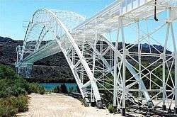 Photo in 2002 | |
   | |
| Location | Abandoned US 66 over the Colorado River, Topock, Arizona |
|---|---|
| Coordinates | 34°42′57″N 114°29′5″W / 34.71583°N 114.48472°WCoordinates: 34°42′57″N 114°29′5″W / 34.71583°N 114.48472°W |
| Area | 0.3 acres (0.12 ha) |
| Built | 1915-16 |
| Built by | Sourwine,S.A.; Et al. |
| Architectural style | Brace-ribbed through arch |
| MPS | Vehicular Bridges in Arizona MPS |
| NRHP reference # | 88001676[1] |
| Added to NRHP | September 30, 1988 |
The Old Trails Bridge over the Colorado River, brought a now-abandoned portion of U.S. Route 66 across from Needles, California to Topock, Arizona. It is a brace-ribbed through arch bridge that was built in 1915-1916.[2] It served as a highway bridge until 1947 when the Red Rock Bridge, formerly a railroad bridge, was modified for highway use. The Old Trails Bridge was later converted to a pipeline bridge.
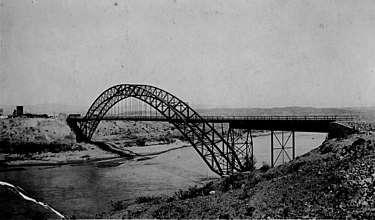
Old Trails Bridge in the 1920s from Arizona
It has also been known as Topock Bridge and as Needles Bridge. It was listed on the National Register of Historic Places in 1988.[1][2]
References
- 1 2 National Park Service (2010-07-09). "National Register Information System". National Register of Historic Places. National Park Service.
- 1 2 Clayton B. Fraser (April 1, 1987). "HABS/HAER Inventory: Old Trails Bridge / Topock Bridge / Needles Bridge". National Park Service. and accompanying photos
External links
- Photo at Flickr, in higher resolution
| Topics | |
|---|---|
| Lists by states |
|
| Lists by insular areas | |
| Lists by associated states | |
| Other areas | |
| |
This article is issued from
Wikipedia.
The text is licensed under Creative Commons - Attribution - Sharealike.
Additional terms may apply for the media files.