Querino Canyon Bridge
|
Querino Canyon Bridge | |
 Querino Canyon Bridge | |
  | |
| Location | Houck, Arizona |
|---|---|
| Coordinates | 35°16′49″N 109°15′28″W / 35.28028°N 109.25778°WCoordinates: 35°16′49″N 109°15′28″W / 35.28028°N 109.25778°W |
| NRHP reference # | 88001623[1] |
| Added to NRHP | September 30, 1988 |
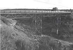
Querino Canyon Bridge is located approximately 4 miles (6.4 km) southwest of Houck, Arizona, on Old Route 66, over Querino Canyon. It is within the boundaries of the Petrified Forest National Park.
History
In 1929 the Arizona Highway Department (AHD) began to renovate what was then U.S. Route 66. The project consisted of approximately 22.5 miles (36.2 km) of grading and road surfacing, as well as the construction of several bridges. The Querino Canyon Bridge was the largest of these. In November, the contract for the bridge and roadways was awarded to F.D. Shufflebarger, a contractor from Phoenix, for a sum of $184,604. While they began work prior to year's end on the roadways, they did not begin work on the bridge until 1930, completing it by December of that year, which was behind schedule.[1]
In the 1960s, this section of Route 66 was re-routed due to the construction of Interstate 40 (I-40), leaving this particular highway to a county road.[1]
Description
The length of the bridge's three spans is 77 feet (23 m), with a total length of 269 feet (82 m) when the approaches are included. The bridge is 20 feet (6.1 m) wide. The substructure consists of concrete abutments and pedestals, along with steel piers. Sitting on the steel piers are three Pratt deck trusses, supporting a concrete deck.[1]
See also


- National Register of Historic Places listings in Apache County, Arizona
References
- 1 2 3 4 National Park Service (2010-07-09). "National Register Information System". National Register of Historic Places. National Park Service.