Valentine, Arizona
| Valentine, Arizona | |
|---|---|
| Unincorporated community | |
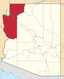
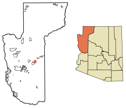 Location of Valentine in Mohave County, Arizona. | |
 Valentine, Arizona Location of Valentine in Mohave County, Arizona.  Valentine, Arizona Valentine, Arizona (the US) | |
| Coordinates: 35°23′15″N 113°39′28″W / 35.38750°N 113.65778°WCoordinates: 35°23′15″N 113°39′28″W / 35.38750°N 113.65778°W | |
| Country | United States |
| State | Arizona |
| County | Mohave |
| Area[1] | |
| • Total | 1.59 sq mi (4.13 km2) |
| • Land | 1.59 sq mi (4.13 km2) |
| • Water | 0.00 sq mi (0.00 km2) |
| Elevation | 3,802 ft (1,159 m) |
| Population (2000) | |
| • Total | 2,380 |
| • Estimate (2016)[2] | N/A |
| Time zone | UTC-7 (Mountain (MST)) |
| ZIP code | 86437 |
| Area code(s) | 928 |
| GNIS feature ID | 13160[3] |
Valentine is an unincorporated community in Mohave County, Arizona, United States. Valentine is located on Arizona State Route 66 (former U.S. Route 66) 26 miles (42 km) northeast of Kingman. Valentine has a ZIP Code of 86437; in 2000, the population of the 86437 ZCTA was 36.[4]
Demographics
| Historical population | |||
|---|---|---|---|
| Census | Pop. | %± | |
| U.S. Decennial Census[5] | |||
References
- ↑ "2016 U.S. Gazetteer Files". United States Census Bureau. Retrieved Jul 18, 2017.
- ↑ "Population and Housing Unit Estimates". Retrieved June 9, 2017.
- ↑ U.S. Geological Survey Geographic Names Information System: Valentine, Arizona
- ↑ American FactFinder
- ↑ "Census of Population and Housing". Census.gov. Retrieved June 4, 2016.
This article is issued from
Wikipedia.
The text is licensed under Creative Commons - Attribution - Sharealike.
Additional terms may apply for the media files.