U.S. Route 41 in Illinois
| ||||
|---|---|---|---|---|
 US 41 highlighted in red | ||||
| Route information | ||||
| Maintained by IDOT and CDOT | ||||
| Length | 64.81 mi[1] (104.30 km) | |||
| Existed | November 11, 1926–present | |||
| Major junctions | ||||
| South end |
| |||
| ||||
| North end |
| |||
| Location | ||||
| Counties | Cook, Lake | |||
| Highway system | ||||
| ||||

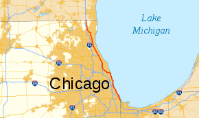
U.S. Route 41 (US 41) in the U.S. state of Illinois runs north from the Indiana border beneath the Chicago Skyway on Indianapolis Boulevard to the Wisconsin border north of the northern terminus of the Tri-State Tollway with Interstate 94. It is the only north–south U.S. Route to travel through a significant portion of the city of Chicago, carrying Lake Shore Drive through the central portion of the city along the lakefront. US 41 in Illinois is 64.81 miles (104.30 km) in length.[1]
Route description
US 41 enters Illinois running concurrently with US 12 and US 20 on the far southeast side of Chicago. They run together until the junction of 95th Street and Ewing Avenue. US 41, then continues down Ewing Avenue for one-half mile (800 m) before heading northwest–southeast along the extension of Lake Shore Drive. Lake Shore Drive continues until US 41 meets South Shore Drive and 79th Street. This is the western terminus of the Lake Shore Drive extension and US 41 continues through the South Shore neighborhood's section of South Shore Drive before reaching the southern terminus of Lake Shore Drive.
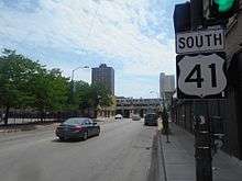
The Lake Shore Drive section of US 41 is a six- to eight-lane highway along the shores of Lake Michigan through Chicago's lakefront park system. It is a limited-access highway except for five signalized intersections near downtown Chicago.
Just short of the northern terminus of Lake Shore Drive, US 41 exits at Foster Avenue. It follows Foster Avenue west for over two miles (3.2 km) and then heads northwest on Lincoln Avenue into neighboring Lincolnwood. Between Lake Shore Drive and Lincolnwood, US 41 intersects US 14 twice; once at its terminus at Foster Avenue and Broadway, and once again at the intersection of Peterson Avenue and Lincoln Avenue.
US 41 is named Skokie Boulevard through Skokie, then its name changes to Skokie Road north of Skokie. Traveling north, it joins I-94 (Edens Expressway) westbound just north of the Old Orchard Shopping Center; they split a few miles north when US 41 becomes the Skokie Highway. The highway serves as a major north–south arterial expressway for much of its routing through Chicago's northern suburbs, as well as an oft-used alternate for truckers avoiding the cost of tolls on the Tri-State Tollway. Before reaching the Wisconsin border, US 41 rejoins I-94 at the northern terminus of the Tri-State Tollway; these two roads continue, toll-free, north one mile (1.6 km) to the Wisconsin border.
History
A $64 million dollar 2-mile Lake Shore Drive extension project extended from 79th Street to 92nd Street/Ewing Avenue/Harbor Avenue as the project began in April 2012. It was made to reroute U.S. Route 41 east through the old U.S. Steel Corp site near Lake Michigan. Old U.S. Route 41 runs South Shore Drive, Baker Avenue, 85th Street, Burley Avenue, 87th Street, and Mackinaw Avenue to hit Harbor Avenue. Once a 2-mile LSD extension was complete, U.S. Route 41 would reroute eastward close to Lake Michigan as the extension was opened in October 27th, 2013[2]
Major intersections
| County | Location | mi[1][3] | km | Exit | Destinations | Notes |
|---|---|---|---|---|---|---|
| Cook | Chicago | 0.00 | 0.00 | Continuation into Indiana | ||
| 0.01 | 0.016 | Tolled; signed as "To I-90 west"; access to I-90 east is in Indiana; I-90 exit 107 | ||||
| 1.71 | 2.75 | Northern end of US 12/US 20 overlap | ||||
| 6.41 | 10.32 | Jeffery Drive, Marquette Drive | ||||
| 6.8 | 10.9 | Hayes Drive (6300 South) | ||||
| 7.7 | 12.4 | 57th Drive | Southern end of freeway | |||
| 8.2 | 13.2 | — | 53rd Street | Southbound exit only | ||
| 8.6 | 13.8 | — | Hyde Park Boulevard (5100 South) | Southbound exit only | ||
| 9.1 | 14.6 | — | 47th Street | |||
| 10.3 | 16.6 | — | Oakwood Boulevard (3940 South) | |||
| 11.3 | 18.2 | — | 31st Street | |||
| 12.0 | 19.3 | — | Northern terminus of I-55 | |||
| 12.7 | 20.4 | — | 18th Drive – Museum Campus | Northern end of freeway | ||
| 12.9 | 20.8 | Waldron Drive (1600 South) | At-grade intersection; northbound exit and entrance only | |||
| 13.2 | 21.2 | Northbound exit and southbound entrance only | ||||
| 13.2 | 21.2 | McFetridge Drive (1326 South) | Northbound exit and entrance only | |||
| 13.4 | 21.6 | |||||
| 13.8 | 22.2 | Balbo Drive (700 South) | ||||
| 14.2 | 22.9 | Eastern terminus of Historic US 66 | ||||
| 14.4 | 23.2 | Monroe Drive (100 South) | ||||
| 14.6 | 23.5 | — | Randolph Street (150 North) | |||
| 14.7 | 23.7 | — | Northbound exit is via Randolph Street; southbound exit is via Grand Avenue | |||
| 15.2 | 24.5 | — | Illinois Street (500 North), Grand Avenue (530 North) | |||
| 15.3 | 24.6 | — | Ontario Street (620 North) | Southbound exit only | ||
| 15.6 | 25.1 | Chicago Avenue (800 North) | At-grade intersection; no southbound exit[lower-alpha 1] | |||
| 15.7 | 25.3 | — | Chestnut Street (860 North) | Southbound exit only | ||
| 16.2 | 26.1 | — | Michigan Avenue/Oak Street (1000 North) | Southbound exit and northbound entrance | ||
| 16.9 | 27.2 | — | Eastern terminus of IL 64 | |||
| 17.8 | 28.6 | — | Fullerton Parkway (2400 North) | |||
| 19.0 | 30.6 | — | Belmont Avenue (3200 North) | |||
| 19.5 | 31.4 | — | Recreation Drive (3400 North) | Northbound exit only | ||
| 20.0 | 32.2 | — | Eastern terminus of IL 19 | |||
| 20.5 | 33.0 | — | Montrose Avenue (4400 North) | |||
| 20.8 | 33.5 | — | Wilson Avenue (4600 North) | |||
| 21.0 | 33.8 | — | Lawrence Avenue (4800 North) | |||
| 21.51 | 34.62 | — | Lake Shore Drive north | Interchange; northern end of Lake Shore Drive overlap; northbound exit and southbound entrance | ||
| 22.01 | 35.42 | |||||
| 25.01 | 40.25 | |||||
| Skokie | 27.9 | 44.9 | ||||
| 29.5 | 47.5 | |||||
| Wilmette | 32.9 | 52.9 | Southern end of I-94 overlap; interchange; southbound exit and northbound entrance | |||
| Northfield | 34.0 | 54.7 | 33 | Willow Road – Winnetka | Exit numbers follow I-94; westbound exit and eastbound entrance; signed as exits 33A (west) and 33B (east) | |
| 35.1 | 56.5 | 31 | Tower Road –Winnetka, Northfield | Westbound entrance and eastbound exit | ||
| Northbrook | 36.7 | 59.1 | 30 | Westbound exit and eastbound entrance; signed as exits 30A (west) and 30B (east) | ||
| 37.3 | 60.0 | Northern end of I-94 overlap; interchange; northbound exit and southbound entrance | ||||
| Cook–Lake county line | Northbrook–Highland Park city line | 37.8 | 60.8 | — | Lake Cook Road | |
| Lake | Highland Park | 38.4 | 61.8 | — | Clavey Road, Skokie Valley Road | |
| 38.8 | 62.4 | Chantilly Road | Northbound exit and entrance | |||
| 40.0 | 64.4 | — | Central Avenue, Deerfield Road – Highland Park | |||
| Northern end of freeway | ||||||
| 41.5 | 66.8 | Separate jughandle ramps for traffic exiting onto IL 22 | ||||
| Lake Forest | 44.7 | 71.9 | ||||
| 45.2 | 72.7 | — | Deerpath Road | |||
| Lake Bluff | 47.5 | 76.4 | Southbound traffic exits via Washington Avenue/Shagbark Road; northbound traffic exits via Skokie Valley Road | |||
| North Chicago | 49.6 | 79.8 | ||||
| Waukegan | 51.6 | 83.0 | — | Northpoint Boulevard | Southbound exit and entrance only | |
| 52.0 | 83.7 | — | Old Skokie Highway | Northbound exit and entrance only | ||
| 52.4 | 84.3 | — | Interchange | |||
| 52.7 | 84.8 | — | Northbound traffic from IL-43 merges onto northbound U.S. Route 41; southbound traffic from U.S. 41 to IL-43 South and IL-120 West use the same ramp | |||
| Gurnee | 53.2 | 85.6 | — | Washington Street | Interchange; northbound ramp also goes to Old Skokie Highway | |
| 54.0 | 86.9 | — | Northbound ramp also goes to Grandville Avenue | |||
| 56.1 | 90.3 | Northern terminus of IL 21 | ||||
| Wadsworth | 59.0– 61.6 | 95.0– 99.1 | ||||
| 62.8 | 101.1 | Tolled; southern end of I-41/I-94 concurrency; southern terminus of I-41; south end of freeway; southbound exit and northbound entrance; exit 1B on I-94; toll-free northbound[4] | ||||
| 63.3 | 101.9 | 1 | Signed as exit 1A southbound | |||
| 64.81 | 104.30 | Continuation into Wisconsin | ||||
1.000 mi = 1.609 km; 1.000 km = 0.621 mi
| ||||||
See also

Notes
- ↑ This intersection is closed to traffic entering & exiting the drive from either direction from 6:45am–9:30am Monday through Friday (traffic light on the drive remains solid green and cones block the turning lanes and exit point; the Chestnut Street southbound exit is unaffected)
References
- 1 2 3 Illinois Technology Transfer Center (2006). "T2 GIS Data". Retrieved 2007-11-08.
- ↑ https://www.nbcchicago.com/traffic/transit/South-Lake-Shore-Drive-Extension-Approaches-Opening-Day-227669071.html
- ↑ Google (March 16, 2017). "Overview Map of US 41" (Map). Google Maps. Google. Retrieved March 16, 2017.
- ↑ GIS/Mapping Division, Lake County Department of Information Technology. "Lake County: Village of Wadsworth" (PDF). Retrieved 26 March 2012.
External links
Route map:
| Previous state: Indiana |
Illinois | Next state: Wisconsin |