U.S. Route 285 in Colorado
| |
|---|---|
| Route information | |
| Maintained by CDOT | |
| Major junctions | |
| South end |
|
|
| |
| North end |
|
| Highway system | |
|
Colorado State Highways
| |
U.S. Route 285 (US 285) is the section north-south highway in Colorado that starts at the New Mexico state line and ends at I-25, US 87, and SH 30 in Denver.
Route description
Heading north from the Colorado border, US 285 passes through the main part of the San Luis Valley, eventually reaching Alamosa. As the highway heads north, it begins to ascend to the northern end of the valley and eventually climbs over Poncha Pass, elevation 9,012 feet (2,747 m), and drops sharply down the other side into the Arkansas River Valley.
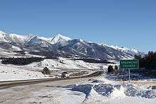
The highway brushes Salida and follows the Arkansas River north up the valley, then takes a sharp eastward turn just before the small town of Buena Vista. 285 then climbs over Trout Creek Pass, elevation 9,346 feet (2,849 m), and enters the high-altitude South Park basin.
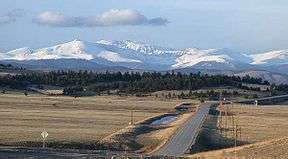
A few miles north, the highway passes through Fairplay and the historic South Park City site, then reaches its highest elevation: 10,051 feet (3,064 m), at the summit of Red Hill Pass. US 285 then leaves the South Park basin and climbs over Kenosha Pass, elevation 10,001 feet (3,048 m), and skirts the south side of the Mount Evans massif as it descends its way through the foothills range towards Denver.
As the highway leaves the Rocky Mountains and reaches Denver's southwest suburbs, it becomes Hampden Avenue, an important artery in the Denver metro area, then reaches its northern terminus at I-25.
On March 14, 2008 both houses of the Colorado legislature, in a unanimous vote, named the section between Kenosha Pass and C-470 the Ralph Carr Memorial Highway.[1][2]
History
The short segment between US 50 at Salida and US 24 at Buena Vista closely parallels the original U.S. Route 650,[3] which was designated in 1926, but eliminated in 1936 when US 285 was commissioned along its present extent from Sanderson to Denver, mostly replacing state-numbered highways.
Between Bailey and Como, US 285 mostly follows the route of the Denver, South Park and Pacific Railroad, part of the original narrow gauge transcontinental railroad.
Junction list
| County | Location | mi[4] | km | Destinations | Notes | ||
|---|---|---|---|---|---|---|---|
| Conejos | | 0.0 | 0.0 | Continuation into New Mexico | |||
| Antonito | 5.2 | 8.4 | South end of SH 17 concurrency | ||||
| Romeo | 12.707 | 20.450 | |||||
| La Jara | 19.817 | 31.892 | |||||
| 20.418 | 32.860 | ||||||
| Alamosa | Estrella | 26.829 | 43.177 | ||||
| Henry | 31.257 | 50.303 | |||||
| Alamosa | 34.102 | 54.882 | North end of SH 17 concurrency; south end of US 160 concurrency | ||||
| Rio Grande | Monte Vista | 51.159 | 82.332 | South end of US 160 concurrency | |||
| Saguache | Center | 62.904 | 101.234 | ||||
| Saguache | 86.290 | 138.870 | |||||
| Villa Grove | 100.518 | 161.768 | |||||
| Chaffee | Poncha Springs | 126.480 | 203.550 | South end of US 50 concurrency | |||
| 126.853 | 204.150 | North end of US 50 concurrency | |||||
| | 133.883 | 215.464 | |||||
| Johnson Village | 148.065 | 238.288 | South end of US 24 concurrency | ||||
| Park | | 161.789 | 260.374 | North end of US 24 concurrency | |||
| Fairplay | 181.971 | 292.854 | South end of SH 9 concurrency | ||||
| 182.989 | 294.492 | North end of SH 9 concurrency | |||||
| No major junctions for miles; highway travels between Pike National Forest and Mount Evans | |||||||
| Jefferson | Pine Junction Area | 231.000 | 371.758 | South Elk Creek Road (Shaffers Crossing) | Interchange | ||
| Pleasant Park Corridor | 235.316 | 378.704 | Kennedy Gulch Road / South Foxton Road | Interchange | |||
| 235.945 | 379.717 | Kitty Drive / Pleasant Park Road | Interchange | ||||
| Aspen Park | 237.062 | 381.514 | Main Street / Light Lane | Interchange | |||
| 237.794 | 382.692 | Conifer Road / Meyer Parkway | Interchange | ||||
| Morrison | 238.877 | 384.435 | South Turkey Creek Road | Interchange | |||
| Homestead | 244.121 | 392.875 | North Turkey Creek Road | Interchange | |||
| | 248.443 | 399.830 | Interchange; south end of freeway | ||||
| | 250.082 | 402.468 | C-470 Exits 5A & 5B | ||||
| Lakewood | 252.052 | 405.638 | South Simms Street | ||||
| 253.512 | 407.988 | ||||||
| 255.034 | 410.437 | ||||||
| City and County of Denver | 256.547 | 412.872 | Interchange; north end of freeway | ||||
| Arapahoe | Sheridan | 258.063 | 415.312 | Interchange | |||
| 259.326 | 417.345 | Interchange | |||||
| Englewood | 260.167 | 418.698 | South Broadway | Interchange | |||
| 261.716 | 421.191 | ||||||
| Arapahoe–Denver county line | Englewood–Denver line | 262.688 | 422.755 | ||||
| City and County of Denver | 262.688 | 422.755 | Eastern terminus of US 285 | ||||
1.000 mi = 1.609 km; 1.000 km = 0.621 mi
| |||||||
References
- ↑
- ↑ "Colorado renames highway to honor Gov. Ralph Carr - Asiaxpress.com - News". Asiaxpress.com. 2008-03-17. Retrieved 2013-11-22.
- ↑ Sanderson, Dale. "End of US highway 650". US Ends .com. Retrieved 21 October 2014.
- ↑ "Highway Data". OTIS - Online Transportation Information System. Colorado DOT. Archived from the original on 10 September 2012. Retrieved 1 September 2017.
| Previous state: New Mexico |
Colorado | Next state: Terminus |