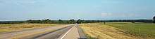
U.S. Route 175
| ||||
|---|---|---|---|---|
|
US 175 highlighted in red | ||||
| Route information | ||||
| Maintained by TxDOT | ||||
| Length | 111.0 mi[1] (178.6 km) | |||
| Existed | 1932–present | |||
| Major junctions | ||||
| West end |
| |||
| East end |
| |||
| Highway system | ||||
| ||||

U.S. Highway 175 (US 175) is an east-west United States highway completely within the state of Texas. It comes very close to meeting its "parent" route, US 75, but decommissioning and rerouting in downtown Dallas, Texas brings it a couple of miles short. Before the decommissioning of US 75 south of downtown Dallas in favor of Interstate 45, US 175 met its "parent" US 75. US 175's western terminus is in Dallas, Texas at Interstate 45. The highway's eastern terminus is in Jacksonville, Texas at an intersection with US 69.
Much of the US 175 corridor (from I-20 in Balch Springs to US 69 in Jacksonville) is part of TxDOT's network of evacuation routes in the event of a hurricane.[2] TxDOT also considers the highway an alternative to using I-20 to travel to and from Dallas-Fort Worth. The state transportation agency feels the corridor is an important aid that students can use to get to Stephen F. Austin State University in Nacogdoches, as well.[3] Besides its hurricane evacuation route status, US 175 is considered part of the National Highway System[4], the Texas Trunk System[5] (later revised to just the portion between Mabank and Jacksonville[6]), and is also included in the state's highway freight network.[7]
Of the 3-digit U.S. routes in Texas, US 175 is the shortest.[1]
Route description
Dallas County
US 175 begins south of downtown Dallas at an interchange with Interstate 45 south of Interstate 30, Cesar Chavez Boulevard, and Good-Latimer Expressway. At this point, US 175 is six lanes in width (three westbound, three eastbound). The highway heads towards the southeast as a freeway carrying the moniker of S.M. Wright Freeway (it was previously named South Central Expressway in this section).
At an interchange with State Highway 310 (known locally as Dead Man's Curve), US 175 begins to head to the east, taking the name C.F. Hawn Freeway, while the S.M. Wright Freeway name follows SH 310. The freeway continues east along the north edge of Rochester Park, through lowlands that include a crossing of White Rock Creek, until it turns back to the southeast at an interchange at Second Avenue (a previous routing of US 175) and Bruton Road; from this point US 175 maintains a consistent southeasterly direction.
US 175 passes through the Pleasant Grove area of Dallas past an interchange with Loop 12 (Buckner Blvd.), then a few miles later, Interstate 20 just southwest of the I-20 and Interstate 635 interchange/split. The highway continues as a freeway past the I-20 interchange, where it briefly crosses into and out of Balch Springs. At this point, US 175 narrows from six lanes to four (two westbound, two eastbound). After a few miles, US 175 leaves Dallas just after the Woody Road exit then goes into the city of Seagoville. The portion of the route through Seagoville is its last urban portion before US 175's surroundings become more suburban and rural.
Kaufman County

On the far side of Seagoville, US 175 passes into Kaufman County and descends into a valley which includes land overseen by the John Bunker Sands Wetland Center and a crossing of the East Fork of the Trinity River. The river marks the city limit boundary between Seagoville and Crandall.
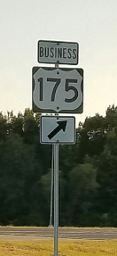
After rising out of the valley area, the highway goes through Crandall by intersecting Farm to Market Road 741 (which connects Crandall to Forney), then passing the center of town, and another exit, with Farm to Market Road 148 (connecting Crandall to Terrell). A few miles later, a rural interchange for County Road 4104-Bud Stoy Road marks the city limit border of Crandall and Kaufman. The freeway continues into Kaufman past a wide right curve at the State Highway 243 interchange, then passes by a brief urban section at the Business State Highway 34 (Washington Street) exit. After another mile, an exit for State Highway 34 comes along.
After that exit, US 175 loses its freeway characteristics but continues as a four-lane divided highway. The highway proceeds for several miles before approaching Kemp. Here a bypass takes US 175 around the north and east of town, while the first of three business routes of US 175 goes through Kemp along US 175's previous routing in the area. After the bypass makes its way past a freeway-style exit at State Highway 274 (which also forms the east end of Business US 175), US 175 leaves the main part of Kemp.
The highway continues as a divided four-lane road past two multi-bridge spans of Cedar Creek Reservoir. Between the two spans is the city limit border between Kemp and Mabank. After the second span of the lake, US 175 begins bypassing the main part of Mabank while another US 175 business route serves a through-town portion along a previous routing of the highway. One part of US 175 along its bypass is freeway-style, at an interchange with State Highway 198. The highway leaves Kaufman County just before completing its bypass of Mabank.
Henderson County
US 175 enters the county as it approaches an at-grade intersection with the east end of Business US 175. The highway continues being divided with four lanes. A rural at-grade intersection with a county road marks the city limit border between Mabank and Gun Barrel City, then US 175 approaches a freeway-style interchange with State Highway 334. This state highway connects to the main portion of Gun Barrel City to the west, and is the last major road connecting US 175 to Cedar Creek Reservoir.

After the interchange, US 175 leaves the city limits of Gun Barrel City, and within a mile, it enters the city limits of Eustace. Soon afterward, the highway narrows to an undivided four-lane road with a left-turn lane. US 175 approaches its first signal light at the intersection of Farm to Market Road 316, which comes into Eustace from the south; the intersection is the beginning of a brief overlap of the two roads near the center of town. FM 316's overlap concludes after four short blocks by turning left at another signal-lighted intersection to go north out of Eustace. US 175 continues out of Eustace and goes on another mile or so before becoming divided once again with four lanes. Once out of Eustace, US 175's speed limit goes up to 75 mph (120 km/h), the highest maximum speed of any segment of the highway.
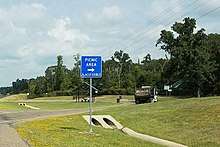
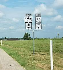
US 175 continues southeast for several more miles, then it passes one of two state-maintained roadside picnic areas. An intersection with Ranch to Market Road 2329 comes up right afterward, then within a mile, US 175 enters the city limits of Athens. A few more miles later, the divided roadway narrows again, to an undivided four-lane road with a left-turn lane. After another mile, US 175 intersects Loop 7; it begins bypassing Athens by turning left and overlapping the loop (as well as State Highway 31, which also bypasses Athens by way of the loop). At this same intersection, the last of US 175's three business routes goes into Athens, along a previous routing of US 175. The portion of the route carrying US 175, SH 31, and Loop 7 is a four-lane highway with a left turn lane. On the north side of Athens, the highway intersects State Highway 19 with a grade-separated exit; the south-bound SH 19 bypasses Athens by merging with US 175, SH 31, and Loop 7 here while north-bound SH 19 turns left to go away from Athens, and a business route of SH 19 begins here to go south into the main part of town.
The four routes continue around Athens eastward past an at-grade intersection with Farm to Market Road 1616. SH 31 turns away from the four-route overlap at the next exit; it leaves by turning left (northeast) toward Tyler, while a business route of SH 31 turns right at the exit to go into Athens. US 175, SH 19, and Loop 7 continue their overlap around to the east edge of Athens, past a grade-separated exit of Farm to Market Road 2495. This road connects to Lake Athens and the Texas Freshwater Fisheries Center. A short distance later, US 175 turns away from SH 19 and Loop 7 at the next exit; US 175 goes left to return to its southeastward path, and the east end of Business US 175 is also found at this exit by turning right from the exit intersection.
The roadway US 175 takes after leaving the Loop and the southeast side of Athens is once again a divided four-lane. After a few miles, US 175 intersects Farm to Market Road 804 in the community of Baxter. Less than a mile after FM 804, and after passing a county road intersection, US 175 goes from four lanes in width to a quite narrow two-lane road with limited sight distances. At the top of a hill, the second and last roadside picnic area maintained by the state alongside US 175 can be found. A couple more miles onward is an intersection with Loop 60 in the community of Larue. The signage at the at-grade turn to the left also points to an eventual intersection with Farm to Market Road 607. A short distance later is an intersection with Ranch to Market Road 2588, on the south side of Larue. Just after the intersection, an overpass bridge briefly takes US 175 up and over an abandoned railroad right-of-way. Another intersection with Loop 60 follows the overpass.
Leaving the vicinity of Larue, and after a few miles, the LaPoynor consolidated school campus can be found on the left side of the highway; it includes a school zone with a speed limit of 35 mph (55 km/h). About a mile past the school campus, at a county road crossing, is the city limits for the town of Poynor. Posted speeds slow to 45 mph (70 km/h) just before reaching the center of town, which includes a brief downtown-style area, and an intersection with Farm to Market Road 315. A signal with blinking yellow lights is posted at the intersection.
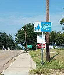
At this point, US 175 becomes part of the Texas Forest Trail, one of several posted regional byways across the state. The Trail wanders around to several protected forest areas and scenic spots around eastern Texas. About a mile further, US 175 reaches the city limit border on the east side of Poynor, then it leaves Henderson County around a mile after that.
Anderson County
US 175 enters the county by going from the narrow two-lane condition to a much better two-lane width that includes shoulders on each side of the road. After a few miles, US 175's first climbing lane is encountered in the westbound lane of the highway at the crest of a hill; it spans less than a half a mile.
Going down the same hill, US 175 crosses the city limit line of Frankston. After another half a mile, the roadway widens to four lanes at the beginning of the urban portion of town. US 175 also goes by the name of Pine Street in Frankston. A few blocks after entering the town, the business district can be seen, with Frankston's downtown area just south of US 175. It is here where the highway intersects State Highway 155, the other major highway that serves the vicinity of Frankston. There is a full signal light at the intersection as well as a left-turn lane on each approach. This intersection marks the end of US 175's segment of the Texas Forest Trail; from here, it turns north to follow SH 155. After SH 155, and over a hill, US 175 leaves the urban portion of Frankston and the four-lane section narrows back to two lanes.
The east city limits of Frankston is crossed in less than two more miles. An assortment of hills, climbing lanes, and gentle curves are encountered on the highway. At the top of a hill east of Frankston is an intersection with Farm to Market Road 1892; this road connects to the south end of Lake Palestine near its dam.
After a gradual downward slope and at the bottom of a hill, the bridge crossing of the Neches River is reached; this is the point where US 175 leaves Anderson County.
Cherokee County
After the bridge span over the Neches River, and a short distance later, US 175 reaches the west city limit border of Cuney. There is not much of a town center besides a city hall and post office, mainly scattered stores, modest homes, and a church along the way. Just after crossing the east city limit border of Cuney, US 175 comes to an intersection with Farm to Market Road 855.
A left curve is ahead, then US 175 enters the community of Reese. There are two cemeteries, one on each side of the highway, then mostly homes and acreages in the community. Upon leaving Reese, there is a curve in the road to the right, then a slight ascent up a long hillside, with a climbing lane eastbound. At the top of the hill and around a wide right curve, US 175 approaches Cove Springs. The community is similar to Reese with mostly homes and acreages alongside the highway.
As US 175 departs Cove Springs, it descends a long hillside with a climbing lane on the westbound side. A county road intersection at the top of the next hill leads south into the community of Church Hill. Then US 175 descends down a slightly longer hill, and a slight right curve to an intersection with County Road 3405, which leads north. The site of the Killough Monument can be accessed by way of this same road.
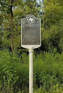
Across from this intersection is a Texas Historical Marker commemorating the past existence of the Neches Saline Road[8] (a part of which is traversed by County Road 3405), a path once used by Native Americans and early area settlers.
After another mile, a county road turns off to the right toward the community of Lakeview. A short hill ahead features climbing lanes in both directions. After another mile or so, US 175 approaches the city limit border on the northwest side of Jacksonville. This part of US 175 in Jacksonville is also known as Frankston Street. Between the city limits and the next street intersection, Pineda Street, an elementary school is on the right, with a special lower school zone speed.
A signal light after three blocks marks an intersection with Farm to Market Road 347 (North Bolton Street). For its final three blocks, US 175 changes street names to Alexander Boulevard and widens to four lanes with a left turn lane, with wide berms beyond the sides of the street, separating it from neighborhoods to the north and south. Another signal light ahead marks an intersection with U.S. Highway 69 (North Jackson Street); this point marks US 175's eastern terminus.[9]
Business routes
There are currently three business routes of U.S. Highway 175.
Business U.S. Highway 175-D (formerly Loop 346) is a business loop that goes east into Kemp from its intersection of US 175 west. The route runs along Elm Street to an intersection with State Highway 274, then turns left to go north, overlapped with SH 274, until intersecting again with US 175. Most of the route is part of a previous route of US 175. The Business route was created in 1991 and is 2.432 miles (3.914 km) long.[10][11]
Business U.S. Highway 175-E is a business loop that runs through Mabank. This route runs on Mason Street, along a previous route of US 175, past an intersection with State Highway 198 until intersecting again with US 175. The business route was created in 1991 when US 175 was rerouted further north and east around town. The route is 2.935 miles (4.723 km) long.[12]
Business U.S. Highway 175-G is a business loop that runs through Athens. This route runs southeast on a previous routing of US 175 from an intersection of US 175 west / State Highway 31 / Loop 7, to an intersection with Business SH 31, then turns left where the two routes overlap on Corsicana Street. At the center of town by the courthouse square, Business SH 31 turns left away from Business US 175-G. The road passes an intersection with Business SH 19 on the east side of the square, then proceeds east, then later curves to the southeast, eventually intersecting again with US 175 / Loop 7 (as well as State Highway 19). The route was created in 2004 when US 175 was rerouted to go to the north and east of Athens on Loop 7. Business US 175-G is 4.871 miles (7.839 km) long.[13]
Former Business routes
There is one former Business Route along US 175. Business U.S. Highway 175-B was located in Crandall between 1992 and 2002 and was 0.6 miles (0.97 km) long. The route went southeast along Main Street from an intersection with the eastbound service road of US 175, to an intersection with Trunk Street, then turned left (northeast) until another intersection with the eastbound service road of US 175. This route had been previously designated Loop 219 before 1992; since 2002, though, the portions along Main and Trunk have been maintained by the city of Crandall.[14][15]
History
An early figure in the formation of what would become US 175 was William Richardson, who settled with his family on land just northwest of Athens in late 1855. Richardson was called upon to help map out an early road path between Athens and Kaufman. The routing US 175 takes now in that area is based in part on what Richardson helped to plan.[16]

Before 1920, and subsequently into the 1930s, a state highway, SH 40, existed from Beaumont to the Texas-Oklahoma border. The routing of SH 40 included a portion between Dallas and Jacksonville. It was this portion that became U.S. Highway 175 by July 1932. The other parts of SH 40 became parts of other US highways (US 77 north of Dallas by 1926;[17] US 271 south of Jacksonville from 1930 to 1934,[18] when the designation transitioned to US 69[19]) as well (Map sources into at least the mid-1930s show a co-signing of US 175 and SH 40 along US 175's entire route; it is unclear whether these were mapping mistakes of some kind or if the two designations were allowed as an orientative transition, if so, it is unclear as to for how long.[20][21][22]). Traces of SH 40's pre-US 175 route exist on 2 street signs, one near Cedar Creek Country Club (between Kemp and Mabank), the other just off SH 274 on the edge of Kemp. These changes phased out the SH 40 designation until almost 60 years later, when a short portion of highway in College Station was given the SH 40 designation in 1994.
As the U.S. system of highways was beginning to spread across the country, there were some routes--and routings--still to be decided. US Highway 77 was one of those. It had made it as far south as Dallas by 1930, but there would be more of it to the south to come. So far in Texas, the path to Dallas for US 77 was along SH 40's route. A petition with over 1000 signatures favoring the extension of US 77 along SH 40 between Dallas and Jacksonville was brought to a September 1930 meeting of the Texas Highway Commission. The delegation heading up the presentation of the petition included W.W. Gibbard, president of the Highway No. 77 Association, R.A. Thompson with the Dallas Chamber of Commerce, and W.R. Cousins of Beaumont, a state Senator. At the meeting, the Commission went on to pass an order requesting the executive committee of AASHO (the American Association of State Highway Officials; now called AASHTO) to consider the US 77 extension. It is not exactly clear what eventually took place with the extension request, but US 77 would go on to be extended southward, toward Waco instead of toward Jacksonville, and of course, US 175 ended up being the numeric designation of the Dallas to Jacksonville SH 40 segment almost 2 years later.[23]
In 1988, the portion of US 75 between Galveston and Dallas was truncated; this included much of South Central Expressway south of downtown. In US 75's place, US 175 was extended north from the South Central-C.F. Hawn interchange to I-45; a separate numbering, SH 310, was used for the portion of South Central south of US 175.[24][25] The state decreed in the mid-1990s that all of South Central Expressway south of I-45 be renamed for Sylvester (S.M.) Wright, who grew up just south of the future Hawn Freeway, in the Bon Ton neighborhood of South Dallas. A pastor at Peoples Missionary Baptist Church, Rev. Wright was influential in his community towards solutions dealing with race in the late 1950s and into the 1960s. George W. Bush, Texas' governor at the time, was in attendance for the rededication ceremony of the freeway.[26][27][28] On April 25, 2013, a minute order was issued by the state Transportation Commission authorizing the change of designation for US 175 to a new direct routing west to I-45. This extension is currently under construction.[29]
At a meeting of the Texas Transportation Commission in January 2015, a minute order was issued authorizing the increase of US 175 speed limits in Kaufman County. In a reversal of what had been a reduction in 2001 of speed limits because of emissions concerns, the commissioners approved the change to a 70 mile per hour speed limit for the whole county. Previously, the part of US 175 between the Dallas County-Kaufman County line and the east side of Crandall had a 60 mile per hour speed limit; while the part from Crandall to the Kaufman County-Henderson County line in Mabank had a 65 mile per hour limit beforehand.[30] By mid-April 2015, updated speed limit signs were in place in the affected area.[31]
Construction projects
- In the 1950s, one of the first improvements along US 175 in Dallas occurred at a signal-lighted intersection in Pleasant Grove; it was the site of several previous accidents. The intersection was made into a freeway-style exit with grade separation and ramps. At the time of construction, US 175 had a vehicles-per-day count of more than 10,000 at the intersection. Right of way there, went from a width of 120 feet (37 m) to 300 feet (91 m). The project commenced in February 1956, and was completed in March 1957. It is at the present-day site of the Loop 12-Buckner Blvd. exit off US 175.[32]
- Not long after work commenced on the new freeway exit in Pleasant Grove, a new machine was being used for installing curbs of concrete down the center of streets surrounding the courthouse square in Athens. One of the streets was Corsicana Street, which was the through-town path of US 175 at the time (now Business US 175).[33]
- In January 1964, a new west terminus was completed, connecting South Central Expressway with Second Avenue. This formed one of the first freeway segments in Dallas on US 175. It also, for the first time, bypassed sections of Dallas which had been served since 175 became a US highway some 32 years earlier. No longer would it connect Deep Ellum, Fair Park, or the Second Avenue corridor of South Dallas. The new freeway's namesake, Charles (C.F.) Hawn, was a businessman from Athens who served on the Texas Highway Commission for six years. He was involved in the family's lumber store, as well as banking, ranching, and development. After aiding in funding dilemmas between Dallas County and the city of Dallas, it was decided that the new freeway east of South Central Expressway in Dallas be named for Hawn. He was present at the dedication, which was attended by dignitaries and family from all along Highway 175, including Athens. The same day, a luncheon was held in Hawn's honor at Market Hall in Dallas.[26][34][35][36]
- Eight years later, in January 1972, an interchange with I-635 was completed. The interchange was constructed in a multi-layer "stack" style. I-635 was originally built along the northern, eastern, and southern sides of Dallas east of I-35E, but a transition between the late 1970s and 1990 eventually truncated I-635's southern part back to just north of its interchange with US 175. The freeway that directly crosses at the US 175 interchange is now part of the path of I-20. Charles Hawn was present at the dedication for the interchange.[36]
Along US 175's path, several cities have been bypassed that previously had been served with through-town routings, including Seagoville, Crandall, Kaufman, Kemp, Mabank, and Athens. Other updates to US 175 have included widenings that have transformed much of the highway; it has become freeway over the years between Dallas and Kaufman, while further southeastward, US 175 has been widened to a divided four-lane highway as far as Baxter, in Henderson County.
The bypassed sections in Seagoville and Crandall came in conjunction with a new alignment between the two cities and a higher bridge over the East Fork of the Trinity River. In Kaufman, the bypass was built as a freeway style to the west and south of downtown, where US 175 was previously routed there. The center of Kemp was bypassed to the north and east in an incomplete freeway style. Mabank's bypass came later, with a mostly freeway-style route to the north and east of town. The construction of Loop 7 around Athens was the catalyst for US 175's bypass there; the city decreed that the loop would be made a truck route, so, as such, the city was able to get the state to reroute the designations of each highway serving the town (US 175, State Highway 19 and State Highway 31) to the loop, making each route bypass the city. US 175's portion was signed afterward along the north and east sides of Loop 7. It appears that LaRue may have been first to be bypassed, but it is unclear as to whether it was formulated in the early years of US 175's time, or if it was done while the path was signed as SH 40. The section in question is currently designated as Loop 60.
There have been many sections that have been widened, mostly to a divided four-lane arrangement, while some have four lanes with a left-turn lane in the middle of the highway. From Kaufman to Kemp, a previously two lane section was made into a four lane divided section, with crossovers to access each side of the highway. From Kemp to Mabank, a two lane section was made into a four lane divided section, with crossovers to access each side of the highway, along with new bridge spans over two sections of Cedar Creek Reservoir, which were built for the new westbound lanes. These were built higher than the bridge spans along the original two lane portion. A multi-phase project from Mabank to Athens began in 2006 to make a two lane section into a four lane divided section between Mabank and Eustace, which included a grade-separation for the intersection of US 175 and SH 334, then, a four-lane section with a left-turn lane within Eustace, then the other phase was widening the two-lane Eustace to Athens portion into a divided four lane highway. The work was completed by 2011. During the 1980s, a two-lane section of US 175 between Athens and Baxter was made into a four-lane divided highway.
- Between May 2001 and April 2002, US 175's east terminus was relocated and straightened in Jacksonville. After many years of zigzagging its way to the center of town, the highway was finally rerouted to a new, wider path for its last three blocks prior to the new intersection with US Highway 69. Harold Alexander, a past city council member in Jacksonville, donated land for the straightening and improvements for the new east terminus and was a proponent of the project. The city named the new three-block section for Alexander at its dedication. There had previously been three east termini in Jacksonville: Frankston Street at North Bolton Street until sometime in the 1960s, when US 69 was rerouted off North Bolton; South Jackson at East Rusk Street, at the south end of a new railroad overpass; and North Jackson at Cherokee Street around 1999.
- In October 2016, a new bypass around the south and east parts of Kaufman was completed for State Highway 34; this project included a new exit on US 175. The exit on US 175 at South Washington Street, SH 34's previous routing, became an exit for Business SH 34 after the opening of the new bypass.[37][38][39] In August 2018, the SH 34 bypass bridge was named for longtime local Congressman Ralph Hall at a dedication ceremony.[40]
Native artifacts unearthed during construction project
After construction commenced on a US 175 widening project between Baxter and Frankston, and prior to July 2015, at least three sites were found by construction workers that contained various items which included stone tools and ceramic vessels. Research showed that Natives settled or farmed in these areas between the 1400s and the mid-1600s. As the archeological process was still taking place by July 2015, TxDOT felt it necessary not to disclose the exact locations of the finds to ensure a secure process, as it is against the law to trespass on sites such as those. Construction workers were able to continue their work elsewhere on the widening project as the protected areas were being probed by investigators.[41]
Future
- There are plans to continue and finish widening the remainder of US 175. The last portion not yet done is a 17-mile (27 km) section between Frankston and Jacksonville. Funding and right-of-way acquisition have not been finalized for that part of the highway.[42]
- Another project involves adding a missing service road along the south side of US 175 between FM 148 in Crandall and the County Road 4106 exit; it wasn't originally built when US 175 was made a freeway there due to close proximity to a parallel section of the Southern Pacific railroad (which has since been abandoned).[42] Construction is scheduled to begin in 2020 and be completed by 2022.[43]
- In conjunction with the service road project, a plan proposed by TxDOT would build a bypass for FM 148 to the east of the current alignment in Crandall; this would include a new exit and overpass at US 175.[44][45] A public hearing was held in Crandall in August 2018 to inform residents there about project plans. According to those plans, letting for construction is due to take place by 2021.[46]
- The intersection of FM 2860 between Kaufman and Kemp has been a candidate for years to be upgraded to a grade-separated, freeway-style exit, but funding hasn't been set aside for this project.
- The US 175 bypass of Kemp is the site of another potential project, to make the intersections at Business US 175 west and at FM 1895 into full freeway-style, grade-separated exits, but no funding has been made available.
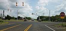 Workers install signals in August 2017 at the US 175/FM 1895 intersection in Kemp. The ones facing FM 1895 will blink red, while US 175 traffic will see yellow flashing signals. This work is likely an interim solution until funding is made available to better improve the intersection.
- A proposal by TxDOT to widen US 175 in Dallas from 6 lanes to 8 lanes between the SH 310 exit and the I-20 interchange is being studied; reportedly no funding is yet available for the project.[42]
- Loop 9, a planned outer loop continuation of the Bush Turnpike, will run between US 67 south of Dallas and I-20 east of Dallas; it is due to intersect with US 175 east of the Malloy Bridge Road exit in Seagoville.[47]
- TxDOT is looking at three different proposals to change the look of and/or change the path of I-30 in the downtown Dallas-to-Fair Park section of that freeway. One proposal would dramatically change I-30's path between the downtown "mixmaster" and the Ferguson Road exit by moving that part of I-30 farther south, traversing the watersheds of the Trinity River and White Rock Creek; in between the two waterways, the interstate would take on US 175's path between I-45 and the Second Avenue-Bruton Road exit. As it is very early in the proposal process, nothing has yet been specified as to whether US 175's route would stay the same in this scenario, or whether the I-30 move would truncate US 175 to a point near the Second Avenue-Bruton Road exit.[48]
Current construction
-
Work is progressing in Dallas on a project to extend the C.F. Hawn Freeway from the 90-degree curve at S.M. Wright Freeway westward across South Lamar Street to a new west terminus at I-45. According to current schematics, the new terminus will only have ramp movements from US 175 west to I-45 north, and from I-45 south to US 175 east. No word has come as to the possibility of having the other two possible ramp movements (west to south, north to east) in present plans. The 90-degree S.M. Wright interchange will be transformed as part of a freeway-to-parkway reconstruction along S.M. Wright. Other associated changes will be made to I-45 just north of the new US 175 interchange.[49][50][51][52] Some think that this project will not only fix a highway problem, but also help toward putting a separated community back together.[53]
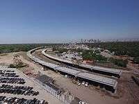
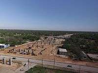 March 2017 construction on US 175 in Dallas:
Left, looking north and west from Lamar Street.
Right, looking east from Lamar Street.
- A three-phase project is underway to widen the portion of US 175 between Baxter and Frankston. One phase will widen the highway from Baxter to just east of LaRue from a very narrow two-lane section to a four-lane divided highway; this phase began construction in April 2015. The second phase is from LaRue to just east of Poynor; it also will make a very narrow two-lane section into a four-lane divided road, with a short service road-style section in front of the LaPoynor School complex, as well as a short bypass of Poynor's downtown area that will include a bridge over FM 315; work started on this phase in October 2015. The third of the three phases goes from just east of Poynor to Frankston with a widening of a two-lane section to a four-lane divided arrangement.[54][3][55][56]
Major intersections
| County | Location | mi | km | Destinations | Notes |
|---|---|---|---|---|---|
| Dallas | Dallas | Westbound exit and eastbound entrance; future I-45 exit 282; future Western terminus | |||
| 0.0 | 0.0 | Westbound exit and eastbound entrance; I-45 exit 283B; current Western terminus | |||
| 0.5 | 0.80 | Cesar Chavez Boulevard / Good-Latimer Expressway | Westbound exit and eastbound entrance | ||
| 0.3 | 0.48 | Martin Luther King, Jr. Boulevard – Fair Park | |||
| 0.8 | 1.3 | Pennsylvania Avenue | Westbound exit and eastbound entrance | ||
| 0.9 | 1.4 | Metropolitan Avenue | |||
| 1.3 | 2.1 | Pine Street | |||
| 1.6 | 2.6 | Elsie Faye Heggins Street | |||
| 1.9 | 3.1 | No direct westbound exit (signed at Elsie Faye Heggins Street) | |||
| 2.3 | 3.7 | Bexar Street | No eastbound entrance | ||
| 2.8 | 4.5 | Railroad Avenue | Westbound exit and eastbound entrance | ||
| 2.6 | 4.2 | Municipal Street | Eastbound access only | ||
| 4.0 | 6.4 | Second Avenue / Bruton Road | |||
| 4.8 | 7.7 | Lake June Road | |||
| 5.4 | 8.7 | Frontage Road | eastbound exit only | ||
| 5.8 | 9.3 | Jim Miller Road | no direct westbound exit (signed at Elam Road) | ||
| 6.3 | 10.1 | Elam Road | |||
| 7.2 | 11.6 | ||||
| 8.2 | 13.2 | Frontage Road | westbound exit only | ||
| 7.7 | 12.4 | Prairie Creek Road | No direct westbound exit (signed westbound at St. Augustine Road) | ||
| 8.8 | 14.2 | St. Augustine Road | |||
| 9.4 | 15.1 | Masters Drive | |||
| Balch Springs | 10.1 | 16.3 | Haymarket Road / Kleberg Road | no eastbound entrance (traffic must continue on service road until after Silverado Drive exit) | |
| 10.4 | 16.7 | I-20 exit 479 | |||
| Dallas | 11.3 | 18.2 | Silverado Drive | ||
| 12.0 | 19.3 | Edd Road | |||
| 12.4 | 20.0 | Belt Line Road | |||
| 12.9 | 20.8 | Woody Road | no direct westbound exit (signed at Stark Road); no direct eastbound entrance (traffic must continue on service road until after Stark Road exit) | ||
| Seagoville | 13.6 | 21.9 | Stark Road | ||
| 11.7 | 18.8 | Simonds Road / Kimberly Drive | |||
| 15.4 | 24.8 | Seagoville Road / Kaufman Street | |||
| 16.3 | 26.2 | Hall Street | |||
| 17.0 | 27.4 | Malloy Bridge Road | |||
| Kaufman | 18.4 | 29.6 | |||
| Crandall | 21.0 | 33.8 | |||
| 21.8 | 35.1 | ||||
| 24.9 | 40.1 | County Road 4106 / Bud Stoy Road | |||
| Kaufman | 27.3 | 43.9 | |||
| 28.5 | 45.9 | ||||
| 29.7 | 47.8 | Frontage Road | |||
| 30.5 | 49.1 | No eastbound entrance | |||
| 31.4 | 50.5 | no eastbound entrance; default entrance for traffic going to westbound US 175 from Business SH 34 | |||
| 31.8 | 51.2 | no direct westbound exit or entrance | |||
| 32.3 | 52.0 | last freeway exit; westbound traffic accessing Business SH 34 must exit here | |||
| | 37.3 | 60.0 | |||
| Kemp | 40.2 | 64.7 | |||
| 41.2 | 66.3 | signaled with flashing yellow/red lights | |||
| 42.0 | 67.6 | Interchange | |||
| Mabank | 48.9 | 78.7 | |||
| 50.5 | 81.3 | Interchange | |||
| Henderson | 52.1 | 83.8 | |||
| Gun Barrel City | 55.0 | 88.5 | Interchange | ||
| Eustace | 57.5 | 92.5 | West end of FM 316 overlap | ||
| 57.8 | 93.0 | East end of FM 316 overlap | |||
| | 63.8 | 102.7 | |||
| Athens | 67.9 | 109.3 | Interchange; west end of SH 31 / Loop 7 overlap | ||
| 69.6 | 112.0 | Interchange; west end of SH 19 overlap | |||
| 71.3 | 114.7 | ||||
| 72.0 | 115.9 | Interchange; east end of SH 31 overlap | |||
| 73.5 | 118.3 | Interchange | |||
| 75.1 | 120.9 | Interchange; east end of SH 19 / Loop 7 overlap | |||
| | 79.4 | 127.8 | |||
| Larue | 84.3 | 135.7 | |||
| 84.7 | 136.3 | ||||
| 85.1 | 137.0 | ||||
| Poynor | 90.0 | 144.8 | |||
| Anderson | Frankston | 95.7 | 154.0 | ||
| | 99.3 | 159.8 | |||
| Cherokee | Cuney | 102.3 | 164.6 | ||
| Jacksonville | 110.8 | 178.3 | |||
| 111.0 | 178.6 | Eastern terminus | |||
1.000 mi = 1.609 km; 1.000 km = 0.621 mi
| |||||
In popular culture
- In the reality series Police Women of Dallas, during transitions between scenes and in return-from-commercial-break bumpers, occasional evening shots of US 175 entrance ramps (signage included) could be seen, with the Dallas skyline lit up in the background.[57][58]
- The Route 66 episode "1800 Days to Justice" was filmed in Crandall, and used a previous routing of US 175 (Trunk Street) in one scene.[59]
See also
References
- 1 2 Transportation Planning and Programming Division (n.d.). "U.S. Highway No. 175". Highway Designation Files. Texas Department of Transportation. Retrieved 2008-03-02.
- ↑ Hurricane Evacuation Routes map, Texas Department of Transportation, May 25, 2016. Retrieved 3-22-2017.
- 1 2 "US 175 from FM 804 to Frankston", Texas Department of Transportation. Retrieved 3-22-2017.
- ↑ "TxDOT National Highway System", Texas Department of Transportation. Retrieved 2018-09-03.
- ↑ "TxDOT Texas Trunk System", Texas Department of Transportation. Retrieved 2018-09-03.
- ↑ "Texas Trunk System Corridor", Texas Department of Transportation. Retrieved 2018-09-03.
- ↑ "TxDOT Texas Highway Freight Network", Texas Department of Transportation. Retrieved 2018-09-03.
- ↑ "Old Neches Saline Road Historical Marker".
- ↑ Google (2008-03-02). "overview map of US 175" (Map). Google Maps. Google. Retrieved 2008-03-02.
- ↑ Transportation Planning and Programming Division. "State Highway Loop No. 346". Highway Designation Files. Texas Department of Transportation. Retrieved 9-28-2015.
- ↑ Transportation Planning and Programming Division. "Business U. S. Highway No. 175-D". Highway Designation Files. Texas Department of Transportation. Retrieved 9-28-2015.
- ↑ Transportation Planning and Programming Division. "Business U. S. Highway No. 175-E". Highway Designation Files. Texas Department of Transportation. Retrieved 9-28-2015.
- ↑ Transportation Planning and Programming Division. "Business U. S. Highway No. 175-G". Highway Designation Files. Texas Department of Transportation. Retrieved 9-28-2015.
- ↑ Transportation Planning and Programming Division. "State Highway Loop No. 219". Highway Designation Files. Texas Department of Transportation. Retrieved 9-28-2015.
- ↑ Transportation Planning and Programming Division. "Business U. S. Highway No. 175-B". Highway Designation Files. Texas Department of Transportation. Retrieved 9-28-2015.
- ↑ "http://atlas.thc.state.tx.us/Details/5213010376 (Details for William Richardson Historical Marker)", Texas Historical Commission. Retrieved 3-18-2017.
- ↑ Transportation Planning and Programming Division. "U. S. HIGHWAY NO. 77", Highway Designation Files, Texas Department of Transportation. Retrieved 3-23-2017.
- ↑ Transportation Planning and Programming Division. "U. S. HIGHWAY NO. 271", Highway Designation Files, Texas Department of Transportation. Retrieved 3-23-2017.
- ↑ Transportation Planning and Programming Division. "U. S. HIGHWAY NO. 69", Highway Designation Files, Texas Department of Transportation. Retrieved 3-23-2017.
- ↑ "Dallas inset, Texas state map", Conoco (H.M. Gousha Co., publisher), 1936. Retrieved 3-24-2017.
- ↑ "East-Southeast section, Texas state map", Conoco (H.M. Gousha Co., publisher), 1936. Retrieved 3-24-2017.
- ↑ "Northeast Texas section, Official Map of the Highway System of Texas, Centennial Edition", March 1, 1936. Retrieved 3-24-2017.
- ↑ "The September Meeting of State Highway Commission", Texas Highways, October 1930, pg. 11. Retrieved 2018-08-19.
- ↑ Transportation Planning and Programming Division. "U. S. HIGHWAY NO. 75", Highway Designation Files, Texas Department of Transportation. Retrieved 3-18-2017.
- ↑ Transportation Planning and Programming Division. "STATE HIGHWAY NO. 310", Highway Designation Files, Texas Department of Transportation. Retrieved 3-18-2017.
- 1 2 Oscar Slotboom, "Dallas-Fort Worth Freeways: Texas-Sized Ambition", Lightning Press, April 2014, Chapter 6, page 296. Retrieved 3-24-2017.
- ↑ Jeff Bounds, "The Wright Stuff," D Magazine/D CEO, June 2016. Retrieved 3-24-2017.
- ↑ "Memorial Tribute," S.M. Wright Foundation. Retrieved 3-24-2017.
- ↑ "TEXAS TRANSPORTATION COMMISSION, MINUTE ORDER 113571", Texas Department of Transportation. Retrieved 2018-09-03.
- ↑ Mathew Richards, "Proposed higher speed limits in Kaufman County approved by Texas Transportation Commission", InForney.com, February 4, 2015. Retrieved 2018-08-08.
- ↑ Mathew Richards, "New, higher speed-limit signs installed along Kaufman County highways", InForney.com, April 14, 2015. Retrieved 2018-08-08.
- ↑ "Another Improvement", Texas Highways, October 1957, pg. 10-11. Retrieved 2018-08-19.
- ↑ Loran S. Thompson, "Channelization with Curbing Machine", Texas Highways, October 1957, pg. 22-23. Retrieved 2018-08-19.
- ↑ "Charles Fred Hawn," Find A Grave, April 13, 2002. Retrieved 3-24-2017.
- ↑ Fred Pass, "Charles F. Hawn Dedicates Freeway Link to East Texas," (by way of and "Today in Dallas photo history - 1964: Hawn Freeway dedicated" Jerome Sims, The Dallas Morning News, January 2013.) The Dallas Morning News, January 28, 1964. Retrieved 3-23-2017.
- 1 2 Oscar Slotboom, "Dallas-Fort Worth Freeways: Texas-Sized Ambition", Lightning Press, April 2014, Chapter 6, page 300. Retrieved 3-25-2017.
- ↑ Mathew Richards, "Lane closures expected next week on U.S. Highway 175 to begin SH 34 bypass construction", InForney.com, January 23, 2015. Retrieved 2018-08-08.
- ↑ "Portions of U.S. Highway 175 frontage roads to be closed for SH 34 construction", InForney.com, January 30, 2015. Retrieved 2018-08-08.
- ↑ "34 Kaufman Bypass open", Kaufman Herald, October 19, 2016. Retrieved 3-18-2017.
- ↑ "Kaufman dedicates bridge to longtime Congressman", Kaufman Herald, September 6, 2018. Retrieved 2018-09-07.
- ↑ "Archeologists uncover ancient artifacts on Hwy 175", Athens Review, July 14, 2015. Retrieved 3-20-2017.
- 1 2 3 "TxDOT Project Tracker," Texas Department of Transportation. Retrieved 3-25-2017.
- ↑ "TxDOT to hold public meeting for U.S. Highway 175 improvements from FM 148 to CR 4104", InForney.com (TxDOT press release), June 29, 2017. Retrieved 2018-08-08.
- ↑ "Public hearing set for Crandall bypass", Kaufman Herald, August 1, 2018. Retrieved 2018-08-08.
- ↑ "FM 148 Bypass from S of FM 3039 to US 175 - Draft EA Available for Public Review and Public Hearing", Keep It Moving Dallas, August 23, 2018. Retrieved 2018-08-08.
- ↑ "Crandall public hearing for FM 148 bypass plans", Kaufman Herald, August 21, 2018. Retrieved 2018-08-24.
- ↑ "Loop 9 Transportation Study", Texas Department of Transportation. Retrieved 3-18-2017.
- ↑ Brandon Formby, "New TxDOT downtown Dallas plan includes a scenario with a freeway's demise", The Dallas Morning News, June 10, 2016. Retrieved 3-22-2017.
- ↑ Ken Kalthoff, "Dallas Dead Man’s Curve Replacement Moving to Construction", KXAS-TV, February 19, 2016. Retrieved 3-18-2017.
- ↑ Demond Fernandez, "TxDOT project aims to fix 'Dead Man's Curve'", WFAA, May 10, 2016. Retrieved 3-18-2017.
- ↑ "S.M. Wright Project - Home". S.M. Wright Project. Keep it Moving Dallas. Retrieved April 27, 2014.
- ↑ "U.S. 175 (S.M. Wright Project)", Texas Department of Transportation, Winter 2017. Retrieved 3-18-2017.
- ↑ Robbie Owens, "'Dead Man's Curve' Getting Long-Awaited Redo," CBSDFW / KTVT (via YouTube), March 6, 2017. Retrieved 3-25-2017.
- ↑ "Open House – US 175 Corridor Improvement Projects", Texas Department of Transportation, February 17, 2016. Retrieved 3-22-2017.
- ↑ "Phase III under way for US 175", Athens Review, May 10, 2016. Retrieved 3-18-2017.
- ↑ "Contracts granted for construction on US 79, US 175 and Loop 323", KLTV, May 5, 2015. Retrieved 3-18-2017.
- ↑ Police Women of Dallas, IMDb.com. Retrieved 2-11-2017.
- ↑ Police Women of Dallas, TV.com. Retrieved 2-11-2017.
- ↑ Route 66 "1800 Days to Justice", IMDb.com. Retrieved 2-11-2017.
Bibliography
- Oscar Slotboom, "Dallas-Fort Worth Freeways: Texas-Sized Ambition," ISBN 9780974160511, Lightning Press, April 2014.
External links
Route map:
- US 175 page at USEnds.com
- US 175 page at dfwfreeways.com
- US 175 video westbound between Belt Line Road exit and I-45 terminus
- US 175 video westbound between Silverado Drive exit and I-45 terminus
- Amateur video of 'Dead Man's Curve' wreckage and fire